Wettelrode
|
Wettelrode
City of Sangerhausen
Coordinates: 51 ° 31 ′ 0 ″ N , 11 ° 17 ′ 0 ″ E
|
|
|---|---|
| Height : | 280 m above sea level NHN |
| Area : | 12.7 km² |
| Residents : | 552 (Jan. 1, 2013) |
| Population density : | 43 inhabitants / km² |
| Incorporation : | October 1, 2005 |
| Postal code : | 06526 |
| Area code : | 03464 |
|
Location of Wettelrode in Sangerhausen
|
|
|
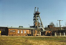
View of Wettelrode
|
|
Wettelrode is a district of the Saxony-Anhalt city of Sangerhausen .
location
The place is on the southern edge of the Harz Mountains and north of the city of Sangerhausen.
history
Wettelroda was first mentioned in a document between 830 and 850. Tim Schultze has been the mayor since April 28, 2016. Until 2005 Wettelrode was a politically independent municipality. On October 1, 2005, it was incorporated into Sangerhausen.
Development of the population (from 1995 December 31st) :
|
|
On the western edge of the former mining village is the Röhrigschacht , in which copper shale was once mined. In GDR times it served as a weather shaft for the Thomas Müntzer shaft . It is the only mining museum with its own rope ride in Saxony-Anhalt.
Individual evidence
- ↑ http://www.sangerhausen.de/ortsteile/wettelrode
- ^ Wolfgang Kahl : First mention of Thuringian cities and villages. A manual. Rockstuhl Verlag, Bad Langensalza, 2010, ISBN 978-3-86777-202-0 , p. 390
- ↑ StBA Area: changes from 01.01. until December 31, 2005
Web links
Commons : Wettelrode - collection of images, videos and audio files


