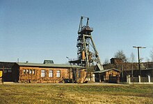
Röhrigschacht
The Röhrigschacht is a former Kupferschiefer - mine and today's mining museum and tourist mine in Wettelrode in the mining region resin in Mansfeld-Südharz in Saxony-Anhalt .
Geographical location
The Röhrigschacht is located in the transition area from the Lower Harz to the southeastern Harz foreland in the Harz Nature Park and in the Karst Landscape South Harz Biosphere Reserve . It is located on the northwest edge of Wettelrode , a northern district of Sangerhausen , south of the Steinberg ( 348.8 m above sea level ). The former factory site is about 305 m above sea level.
history
In Mansfeld , Southeast resin and southeastern Harzvorland copper mining was operated from 1200 to 1990, for example, in Sangerhäuser ground and thus in Röhrigschacht . The shaft is part of the historic mining landscape of the southeastern Harz foreland. Its headframe, dating from 1888, is one of the oldest in Europe.
museum
In the mining museum (above ground ), which opened in 1987, you can find out about the formation of deposits, geology and mineralogy as well as the 800-year history of mining. There are historical and more recent challenges , such as drilling, compressed air and charging devices, means of transport, mining mechanization, as well as devices and machines for weather management and dewatering are exhibited and explained.
In the show mine (underground), which opened in 1991, visitors can take guided tours with the shaft hoisting system down to a depth of 283 m and then take the mine train to a copper shale seam 1,000 m away in a mining field from the 19th century. There, the former dismantling from the beginnings to the modern era is demonstrated and explained using exhibits. During these tours, the main pit fan will also be viewed and explained.
hike
The Röhrigschacht was included earlier as No. 222 in the system of stamp points of the Harz hiking pin. Today's stamping point No. 222 is located about 420 m northwest on the Wettelrode mining educational trail , which begins at the parking lot in front of the Röhrigschacht and in sections divides the route with the Karst hiking trail . The latter leads past the former mine about 300 m north.
Individual evidence
- ↑ Saxony-Anhalt viewer of the State Office for Surveying and Geoinformation ( notes )
- ↑ a b History of the Röhrigschacht, on roehrigschacht.de
- ↑ a b The mining museum (above days), on roehrigschacht.de
- ↑ a b c d The show mine (underground), on roehrigschacht.de
- ↑ Harzer Wanderadel: Former stamp point 222 / Röhrigschacht show mine ( memento from February 6, 2013 in the web archive archive.today ), from harzer-wandernadel.de
- ↑ Harzer Wanderadel: Today's stamp point 222 / Bergbaulehrpfad Wettelrode , on harzer-wandernadel.de
Web links
- Show mine Röhrigschacht (homepage)
Coordinates: 51 ° 31 ′ 2.7 ″ N , 11 ° 16 ′ 57 ″ E

