
Westpark (Bochum)
The Westpark Bochum is the starting point for the urban development of the " Inner City West" in Bochum's inner city . The total area available for urban development is around 75 hectares. The implementation of the measure began with the approximately 38 hectare park, the first phase of which was completed and opened in 1999. The center Westpark now forms the converted event venue Centennial Hall . The areas immediately around the Jahrhunderthalle and some of the surrounding areas will gradually be brought into their final form until 2006 when the RuhrTriennale is not event-free . The redesign was awarded the National Prize for Integrated Urban Development and Building Culture by the Federal Ministry of Transport in 2009 .
On the site of the former pump house next to the Jahrhunderthalle, the construction of a concert hall for the Bochum Symphony Orchestra was also planned, which, however, will be built in 2007 in the Marienviertel in the city center.

history


The basic structure of the park design is the legacy of the industrial use of the site, which goes back to the settlement of Mayer's cast steel factory on Alleestrasse in 1842. Steel products ranging from church bells to cannon production to ICE wheel tires have been manufactured here for 160 years. The blast furnaces were shut down in 1968 and the steel mill in 1985. Steel is only used in the eastern part of the entire area (see Bochumer Verein ).
The past of the site is divided into layers. Building and plant structures each formed the basis of a new layer that builds on the previous one. The slag, the waste product of the metallurgical industry and the bulk goods transport required for heavy industry contributed to the division of the area into flat levels at different heights. The exciting topography of the area forms the main design approach of the Westpark. After production was shut down, almost all the buildings were demolished, leaving an industrial wasteland densely covered with spontaneous vegetation.
The special features of the site that are valuable in terms of industrial architecture are the Centennial Hall in the center, the water tower that can be seen from afar as a landmark, and the Colosseum , a striking retaining wall structure in the south-western access area of the park.
Terrain structure and flora of the park
The park is divided into three height levels:
- lower city level at about 72 m above sea level. NN in the southwest, area around the Colosseum.
- The level of the Centennial Hall at 80 m above sea level. NN, basin in the center of the Westpark.
- The plateau of the West Park at 90 m above sea level. NN, artificially created level on which the blast furnaces and the steel mill used to stand.
The park appropriates the old structures and reinterprets them into a new, usable, sustainable order. The technical, artificial-looking topography is given and further developed by retaining walls, paved steep slopes and jumps in the terrain.
The park, in essential parts on the highest level, offers the unique opportunity to view the outside into the city quarters and inside onto the area of the Centennial Hall. The approximately one kilometer long circular route leads around the center 10 m below, with the Centennial Hall, which has been converted into the main location of the Triennale. The path leads over bridge structures, along steeply sloping embankments or retaining walls, through the light birch forests of the "industrial nature".
Pioneering plants such as birch, willow, poplar and the intensely fragrant butterfly lilac have populated the areas and have grown into an industrial forest that is being cared for and developed over the last twenty years .
In the north there is the gently sloping high plateau with the open play areas, the high path with a view of the region and the observation bastion in the transition to the bridge of the ore railway in the green corridor towards Gelsenkirchen and Herne . From the “inner edge of the kettle”, the southern path of the high plateau, glimpses of the park areas around the Centennial Hall open up. In view of the cultural events in the hall, it will take a few more years to complete the space.
In the west, the path leads over a narrow embankment of the “North Pole” through a light birch forest past the “water landscape of the old cooling plant” to the “North Pole Bridge”. The new bridge overcomes a deep gorge of access roads and the track of the "mountain railway". The bridge, which is interactively illuminated at night, offers the best view of the converted Centennial Hall; it also enables the connection to the plateau of the former steelworks. The area of the former steel works is reserved for residential development.
As a preparatory measure, a wide aisle was exposed: an archaeological field with the remains of the 160-year steel industry history with tunnel vaults, foundations, furnace foxes and concrete slabs is revealed to the park visitor.
On the lower ground level, on the forecourt level of the Jahrhunderthalle, are the retention basins that store the rainwater from the paved areas of the Westpark and release it towards Marbach after a delay .
The circular route leads along the northern edge of the slope to the children's play area "Steelworks dragon", a play area in the shape of a dragon. His steel head peeps out from behind the high hedge walls into the park's access area. At the same time, it marks a central pivot point in the route relationships. Visitors arriving in the park from the underground tram stop Bochumer Verein / Jahrhunderthalle via a wide step ramp are directed onto the axle line in the direction of the water tower. This large diagonal is the future extension of the Rottstraße coming from the main station, which leads to the water tower and the foyer of the Jahrhunderthalle.
The path from the play area to the north leads to the 180 m long footbridge, which, at treetop height, connects to the northern plateau and closes the circular path system. As if from a spectator stand, views of the central area with the Centennial Hall and the planned concert area are possible.
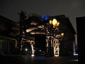
The park gets its “night face” from the lighting developed by Uwe Belzner and tailored to the location. The illumination intensity is kept low overall, the special structures of the place are carefully worked out. The place, which has been busy at all times of the day and night for over 160 years, retains its night activity as a public park.
The night lighting of interesting objects in the park was added in winter 2007. In addition to the deep blue illuminated water tower in the immediate vicinity of the Centennial Hall, the two concrete cooling towers were illuminated in blue and the cooling water basin shines in warm yellow and orange colors. The interior lighting of separated pipelines and the illumination of bridges and pipeline routes provide additional accents.
use
The Jahrhunderthaus Bochum was opened in 2006 on Alleestraße as the new trade union building of IG Metall.
photos

The union building of IG-Metall at the southern entrance to the park

Illuminated cooling towers in Westpark
Illuminated pipelines at the Centennial Hall

Avenue of rails
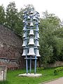
Cast steel chimes


literature
- Westpark Bochum, history and stories by Karl Ganser, Tom Sieverts and Jens Trautmann; Klartext-Verlag, 2007, ISBN 9783898618113
Web links
Individual evidence
- ↑ StadtbauenStadtleben.de: Results> Designing cities better. Accessed December 9, 2011.
Visitor center and anchor points (from west to east): Museum of German Inland Shipping | Inner harbor Duisburg | LVR Industrial Museum Oberhausen | Landscape Park Duisburg-Nord | Gasometer Oberhausen | Aquarius Water Museum | St. Antony Hut | Villa Huegel | Nordsternpark | Zeche Zollverein World Heritage Site and Zollverein Coking Plant | Ewald colliery | Marl Chemical Park | Railway Museum Bochum-Dahlhausen | Henrichshütte | Centennial Hall Bochum | Recklinghausen substation | German Mining Museum | Nightingale colliery | Henrichenburg ship lift | DASA | Hansa coking plant | Zeche Zollern II / IV | Hohenhof | Hagen Open Air Museum | Lindenbrauerei Unna | Maximilian Park Hamm
Themed routes (in ascending order by number): 1. Duisburg: City and Harbor | 2. Industrial cultural landscape Zollverein | 3. Duisburg: industrial culture on the Rhine | 4. Oberhausen: Industry makes the city | 5. Krupp and the city of Essen | 6. Dortmund: triad coal, steel and beer | 7. Industrial culture on the Lippe | 8. Erzbahn-Emscherbruch | 9. Industrial culture at Volme and Ennepe | 10. Brine, steam and coal | 11. Early industrialization | 12. The past and present of the Ruhr | 13. On the way to the blue Emscher | 14. Canals and shipping | 15. Lanes in the area | 16. Westphalian mining route | 17. Rhenish mining route | 18. Chemistry, Glass and Energy | 19. Workers' settlements | 20. Entrepreneur villas | 21. Bread, grain and beer | 22. Myth of the Ruhr Area | 23. Parks and Gardens | 24. Industrial nature | 25. Panoramas and Landmarks | 26. Sacred buildings | 27. Iron & Steel | 28. Water: works, towers and turbines | 29. Bochum - industrial culture in the heart of the district | 30. Gelsenkirchen | 31. Industrial Culture and Bauhaus Route | by bike
Centennial Hall Bochum ![]() |
Westpark |
Colosseum |
Mechanical workshops of the Bochumer Verein |
Stahlhausen settlement |
Bochum Transport Technology Association |
Ore rail link |
Ore railway |
Glückauf settlement |
United Carolinenglück colliery 2/3 |
Epiphany Church - Autobahn Church RUHR |
Dahlhauser Heide settlement
|
Westpark |
Colosseum |
Mechanical workshops of the Bochumer Verein |
Stahlhausen settlement |
Bochum Transport Technology Association |
Ore rail link |
Ore railway |
Glückauf settlement |
United Carolinenglück colliery 2/3 |
Epiphany Church - Autobahn Church RUHR |
Dahlhauser Heide settlement ![]() |
Ore Railway Bridge 4 |
Hannover Colliery 1/2/5 |
Workers' houses Am Rübenkamp |
Königsgrube settlement |
Ore Railway Bridge 6 |
Hanover Colony |
Erzbahnbrücke 9 - pillar bridge |
Kray Wanner Railway |
Alma coking plant |
Torhäuser, Schalke Club |
Chatten- / Preußenstraße settlement |
Ore Railway Bridge 10 |
Erzbahnbrücke 11 |
Ore Railway Bridge 13 |
Ore Railway Bridge 14 |
Pluto-Wilhelm colliery |
Consolidation 3/4/9 |
Graf Bismarck Colliery 1/4 |
Railway depot Gelsenkirchen-Bismarck |
Port of Grimberg |
Grimberger sickle |
Zeche Unser Fritz 1/4 |
Local museum Our Fritz |
Künstlerzeche Our Fritz 2/3 |
Rhine-Herne Canal |
Fleuthe Bridge |
Port Wanne-West |
Wanne-Eickel lock |
Recklinghausen training mine |
Recklinghausen Colliery I |
Recklinghausen II colliery |
Dreieck-Siedlung Hochlarmark |
Landscape Park Hoheward
|
Ore Railway Bridge 4 |
Hannover Colliery 1/2/5 |
Workers' houses Am Rübenkamp |
Königsgrube settlement |
Ore Railway Bridge 6 |
Hanover Colony |
Erzbahnbrücke 9 - pillar bridge |
Kray Wanner Railway |
Alma coking plant |
Torhäuser, Schalke Club |
Chatten- / Preußenstraße settlement |
Ore Railway Bridge 10 |
Erzbahnbrücke 11 |
Ore Railway Bridge 13 |
Ore Railway Bridge 14 |
Pluto-Wilhelm colliery |
Consolidation 3/4/9 |
Graf Bismarck Colliery 1/4 |
Railway depot Gelsenkirchen-Bismarck |
Port of Grimberg |
Grimberger sickle |
Zeche Unser Fritz 1/4 |
Local museum Our Fritz |
Künstlerzeche Our Fritz 2/3 |
Rhine-Herne Canal |
Fleuthe Bridge |
Port Wanne-West |
Wanne-Eickel lock |
Recklinghausen training mine |
Recklinghausen Colliery I |
Recklinghausen II colliery |
Dreieck-Siedlung Hochlarmark |
Landscape Park Hoheward ![]() with the dumps Hoheward / Hoppenbruch |
Emscherbruch |
Ewald colliery |
with the dumps Hoheward / Hoppenbruch |
Emscherbruch |
Ewald colliery |![]()
![]()
House Ripshorst |
Landscape Park Duisburg-Nord ![]() |
Fallow Vondern |
Track park Frintrop | Zollverein World Heritage Site with colliery , coking plant and heaps |
Mechtenberg Landscape Park |
Halde Rheinelbe and Sculpture Forest |
Hoheward Landscape Park |
Colliery Hannover I / II / V - Königsgrube Park |
Westpark |
Henrichshütte |
Lothringen I / II |
Nightingale colliery |
Zollern heap |
Hallerey Nature Reserve |
Hansa coking plant |
Heap of large wood |
Beversee nature reserve |
Stockpile Saxony
|
Fallow Vondern |
Track park Frintrop | Zollverein World Heritage Site with colliery , coking plant and heaps |
Mechtenberg Landscape Park |
Halde Rheinelbe and Sculpture Forest |
Hoheward Landscape Park |
Colliery Hannover I / II / V - Königsgrube Park |
Westpark |
Henrichshütte |
Lothringen I / II |
Nightingale colliery |
Zollern heap |
Hallerey Nature Reserve |
Hansa coking plant |
Heap of large wood |
Beversee nature reserve |
Stockpile Saxony![]()
![]()
![]()
![]()
![]()
![]()
![]()
![]()
![]()

Centennial Hall Bochum ![]() |
Westpark |
Colosseum |
Mechanical workshops of the Bochumer Verein |
Bochum Transport Technology Association |
Stahlhausen settlement |
Bochum Association, Steel Industry Plant |
Heintzmann Company |
Rombacher Hut |
Bochum Association, Höntrop plant |
Werksbahn Bochumer Verein and Erzbahn |
Glückauf settlement |
United Carolinenglück colliery 2/3 |
Epiphany Church - Autobahn Church RUHR |
Dahlhaus Heide settlement
|
Westpark |
Colosseum |
Mechanical workshops of the Bochumer Verein |
Bochum Transport Technology Association |
Stahlhausen settlement |
Bochum Association, Steel Industry Plant |
Heintzmann Company |
Rombacher Hut |
Bochum Association, Höntrop plant |
Werksbahn Bochumer Verein and Erzbahn |
Glückauf settlement |
United Carolinenglück colliery 2/3 |
Epiphany Church - Autobahn Church RUHR |
Dahlhaus Heide settlement ![]() |
Hannover Colliery I / II / V |
Workers' houses Am Rübenkamp |
Hanover Colony |
Colliery Holland 3/4/6 |
Mining hiking trail Wattenscheid |
Villa Baare |
Railway Museum Bochum |
Dr. C. Otto |
Dahlhausen railway station |
Mining Trail Dahlhausen |
Dahlhausen floating bridge | Grave of Heinrich Kämchen |
Peaceful neighbor colliery |
Peaceful Neighbor Colony |
Weitmar water tower |
Homecoming Thank You Church |
Mining hiking trail Bochum-Süd |
Gahlenscher Kohlenweg |
Brockhauser civil engineering colliery |
Blankenstein lock and Stiepel waterworks |
Klosterbusch colliery and Ruhr University mining trail |
United Gibraltar Mine |
Kemnader See |
Malakow Tower Julius Phillip |
Consumer association welfare |
Fa. Eickhoff |
Melanchthon Church |
Federal Miners' Association |
Bergmannsheil |
House of the History of the Ruhr Area |
Playhouse |
Tippelsberg
|
Hannover Colliery I / II / V |
Workers' houses Am Rübenkamp |
Hanover Colony |
Colliery Holland 3/4/6 |
Mining hiking trail Wattenscheid |
Villa Baare |
Railway Museum Bochum |
Dr. C. Otto |
Dahlhausen railway station |
Mining Trail Dahlhausen |
Dahlhausen floating bridge | Grave of Heinrich Kämchen |
Peaceful neighbor colliery |
Peaceful Neighbor Colony |
Weitmar water tower |
Homecoming Thank You Church |
Mining hiking trail Bochum-Süd |
Gahlenscher Kohlenweg |
Brockhauser civil engineering colliery |
Blankenstein lock and Stiepel waterworks |
Klosterbusch colliery and Ruhr University mining trail |
United Gibraltar Mine |
Kemnader See |
Malakow Tower Julius Phillip |
Consumer association welfare |
Fa. Eickhoff |
Melanchthon Church |
Federal Miners' Association |
Bergmannsheil |
House of the History of the Ruhr Area |
Playhouse |
Tippelsberg ![]() |
Steelworks Bochum |
Industrial nature trail Gerthe / Grumme / Hiltrop |
Christ Church Gerthe |
Lothringen colliery |
Lorraine dump |
Vinzentiuskirche |
Ev. Church of Werne |
Robert Müser Colliery |
Neu-Iserlohn coking plant |
Langendreer train station with the cultural center |
Distillery Eickelberg |
Müser Brewery |
Opel |
Bochum main cemetery |
Scharoun Church |
BP Aral Headquarters |
Bochum City Archives |
Kortum Park |
Bogestra Headquarters |
Bochum Central Station |
Bochum Nord train station and Bochum steel bridges |
Fiege Brewery | Bell Bochumer Verein ( town hall ) |
Schlegel Brewery |
Christ Church Bochum Center |
Sparkasse Bochum |
Villa Nora and Villa Rosenstein-Markhoff |
City Park Bochum |
Mountain School TFH Georg Agricola |
German Mining Museum
|
Steelworks Bochum |
Industrial nature trail Gerthe / Grumme / Hiltrop |
Christ Church Gerthe |
Lothringen colliery |
Lorraine dump |
Vinzentiuskirche |
Ev. Church of Werne |
Robert Müser Colliery |
Neu-Iserlohn coking plant |
Langendreer train station with the cultural center |
Distillery Eickelberg |
Müser Brewery |
Opel |
Bochum main cemetery |
Scharoun Church |
BP Aral Headquarters |
Bochum City Archives |
Kortum Park |
Bogestra Headquarters |
Bochum Central Station |
Bochum Nord train station and Bochum steel bridges |
Fiege Brewery | Bell Bochumer Verein ( town hall ) |
Schlegel Brewery |
Christ Church Bochum Center |
Sparkasse Bochum |
Villa Nora and Villa Rosenstein-Markhoff |
City Park Bochum |
Mountain School TFH Georg Agricola |
German Mining Museum ![]()
Coordinates: 51 ° 28 ′ 45 ″ N , 7 ° 12 ′ 12 ″ E