
Tippelsberg


The Tippelsberg is an elevation and a local recreation area in the north of Bochum .
The mountain itself is a relatively high elevation in the landscape for the Middle Ruhr Area, which forms a landmark in the Bochum districts of Grumme , Riemke and Bergen .
In the 20th century, the Tippelsberg was used as a landfill for construction and ground rubble for a period of 14 years . Among other things, the excavation of the Bochum underground line U35 was deposited here. This more than compensated for the height of the natural crest , which had been lost due to subsidence .
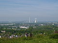
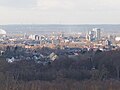
The artificially raised summit today reaches a height of 150 meters above sea level (40 meters above the surrounding area), the extension of the cone is 18.5 hectares. From the summit you can see far into the Ruhr area on a clear day.

The newly designed and renatured area was made available to visitors again in the summer of 2007 as a local recreation area with hiking trails and a viewing platform. A lying cross made of stone gabion with a wooden cover is installed on the summit . All around there are eight steel steles that offer a "district view of cultural sites in Bochum and the surrounding area". The paths to the exits in the north and south are designed with different floor coverings (pebbles, grit, mulch, gravel), including a “path of the giants” and a “path of the children”.
The Tippelsberg is the subject of various folk tales. One of them reads: The giant Tippulus once completed a long journey. On the way he stopped to remove clumps of clay from his shoes, which resulted in the Tippelsberg. Allusions to these legends were installed as landscape elements on the mountain, for example a huge footprint.
In the Ruhr.2010 Capital of Culture year , the Tippelsberg was one of the most visited viewpoints during the SchachtZeichen campaign . Since the beginning of 2011, the Tippelsberg has been listed as a panorama in the Route of Industrial Culture.
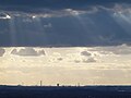
Views from the Tippelsberg
Several images have notes on Commons
Shaft mark

Houses in downtown Essen
Looking west

Hoheward dump
Herne


Individual evidence
- ^ Heinrich Kämchen : The Hünenstein. 1909 ( online )
Web links
- Description of the sight and panorama point on the route of industrial culture
- Halden Ruhr - The Tippelsberg in Bochum
- City of Bochum - June 15, 2018 - Opening of the nature trail "Tippelsberg and Berger Mühle"
Coordinates: 51 ° 30 '25.93 " N , 7 ° 13' 37.95" O
Visitor center and anchor points (from west to east): Museum of German Inland Shipping | Inner harbor Duisburg | LVR Industrial Museum Oberhausen | Landscape Park Duisburg-Nord | Gasometer Oberhausen | Aquarius Water Museum | St. Antony Hut | Villa Huegel | Nordsternpark | Zeche Zollverein World Heritage Site and Zollverein Coking Plant | Ewald colliery | Marl Chemical Park | Railway Museum Bochum-Dahlhausen | Henrichshütte | Centennial Hall Bochum | Recklinghausen substation | German Mining Museum | Nightingale colliery | Henrichenburg ship lift | DASA | Hansa coking plant | Zeche Zollern II / IV | Hohenhof | Hagen Open Air Museum | Lindenbrauerei Unna | Maximilian Park Hamm
Themed routes (in ascending order by number): 1. Duisburg: City and Harbor | 2. Industrial cultural landscape Zollverein | 3. Duisburg: industrial culture on the Rhine | 4. Oberhausen: Industry makes the city | 5. Krupp and the city of Essen | 6. Dortmund: triad coal, steel and beer | 7. Industrial culture on the Lippe | 8. Erzbahn-Emscherbruch | 9. Industrial culture at Volme and Ennepe | 10. Brine, steam and coal | 11. Early industrialization | 12. The past and present of the Ruhr | 13. On the way to the blue Emscher | 14. Canals and shipping | 15. Lanes in the area | 16. Westphalian mining route | 17. Rhenish mining route | 18. Chemistry, Glass and Energy | 19. Workers' settlements | 20. Entrepreneur villas | 21. Bread, grain and beer | 22. Myth of the Ruhr Area | 23. Parks and Gardens | 24. Industrial nature | 25. Panoramas and Landmarks | 26. Sacred buildings | 27. Iron & Steel | 28. Water: works, towers and turbines | 29. Bochum - industrial culture in the heart of the district | 30. Gelsenkirchen | 31. Industrial Culture and Bauhaus Route | by bike
Stockpile Rheinelbe | Tippelsberg | Hoheward landscape park with the Hoppenbruch / Hoheward dumps | Schwerin dump | Heap of large wood | Kissinger Höhe | TV tower Florian | Hohensyburg | Berger memorial | Tiger & Turtle | Stockpile Rhine Prussia | Halde Pattberg | Alsumer Berg | Halde Haniel with Stations of the Cross , amphitheater, installation "Totems" | Tetrahedron | Dump Rungenberg | Schurenbachhalde

German Mining Museum |
Mountain School TFH Georg Agricola |
Federal Miners' Association |
Bergmannsheil |
Tippelsberg |
Julius Philipp colliery - Medical history collection in the Malakow Tower |
Brockhauser civil engineering colliery |
Peaceful neighbor colliery |
Alte Haase colliery |
Nightingale colliery |
Neu-Iserlohn coking plant |
Robert Müser Colliery , Arnold Shaft |
Lothringen colliery |
Zeche Zollern |
Landwehr Colony |
Hansa coking plant |
Westhausen colliery |
Adolf von Hansemann colliery |
Colliery Minister Stein / Neue Evinger Mitte |
Old colony of Eving with welfare building |
Landesoberbergamt Dortmund | Mining memorials on the Ostfriedhof |
Gneisenau colliery |
Müsersiedlung of the Gneisenau colliery |
Monopoly colliery , Grillo shaft |
Koenigsborn 3/4 colliery |
Maximilianpark |
Westphalia Colliery |
Zeche Sachsen - Eco-Center NRW |
Radbod colliery |
Radbod Colliery Memorial |
Kissinger Höhe |
East mine , Heinrich Robert shafts |
Lark shaft |
Werne colliery |
Monopol mine, Grimberg shaft 1/2 |
Heap of large wood |
Colliery House Aden |
Ziethenstrasse settlement |
Zeche Minister Achenbach , shaft 4 - LÜNTEC Tower |
Miners Residential Museum |
Waltrop colliery | Hammerhead tower Zeche Erin 3 |
Schwerin dump |
Erin colliery 7 |
Ewald Colliery Continuation |
Vestisches Museum |
Recklinghausen II colliery |
Dreieck-Siedlung Hochlarmark |
Landscape Park Hoheward with the dumps Hoheward / Hoppenbruch |
Ewald Colliery 1/2/7 |
Colliery mallets & iron 3/4/7 |
Colliery mallets & iron 5/6 |
Auguste Victoria mine , shaft 1/2 |
Auguste Victoria mine , shaft 3/7 |
Prince Leopold Mine |
Fürst Leopold settlement | Machine hall Zeche Zweckel |
RBH Logistics |
Halde Haniel |
Arenberg colliery continuation |
Tetrahedron |
Prosper II colliery |
Prosper coking plant |
Garden City Welheim |
Mottbruchhalde - "Halde im Wandel" |
Colliery Hugo |
Schüngelberg settlement |
Dump Rungenberg |
Bergmannsglück colliery |
Westerholt mine |
Nordsternpark |
Oberschuir shaft |
Consolidation 3/4/9 |
Graf Bismarck Colliery 1/4 |
Alma coking plant |
Settlement Flöz Dickebank |
Rheinelbe Science Park |
Stockpile Rheinelbe |
Colliery Holland 1/2 |
Colliery Holland 3/4/6 |
Zeche Unser Fritz 1/4 |
Local history and natural history museum Wanne-Eickel |
Pluto-Wilhelm colliery |
Hannover Colliery I / II / V |
Dahlhauser Heide settlement |
United Carolinenglück colliery 2/3 |
Flottmann halls | Kunstwald Zeche Teutoburgia |
Teutoburgia settlement![]()
![]()
![]()
![]()
![]()
![]()
![]()
![]()
![]()
![]()
![]()
![]()
![]()
![]()
![]()
![]()
![]()
![]()
![]()
![]()
![]()
![]()

West Pole |
Headframe Bönen - East Pole |
Stockpile North Germany |
Halde Pattberg ![]() |
Stockpile Rhine Prussia
|
Stockpile Rhine Prussia ![]() |
Rhine orange |
Tiger & Turtle
|
Rhine orange |
Tiger & Turtle ![]() on the Heinrich-Hildebrand-Höhe in Angerpark |
Alsumer Berg
on the Heinrich-Hildebrand-Höhe in Angerpark |
Alsumer Berg ![]() |
Landscape Park Duisburg-Nord
|
Landscape Park Duisburg-Nord ![]() |
Knappenhalde |
Gasometer Oberhausen
|
Knappenhalde |
Gasometer Oberhausen ![]() |
Halde Haniel
|
Halde Haniel ![]() |
Tetrahedron
|
Tetrahedron ![]() on the Beckstrasse heap |
Schurenbachhalde
on the Beckstrasse heap |
Schurenbachhalde ![]() | World cultural heritage Zeche Zollverein XII | World cultural heritage Zollverein coking plant |
Mechtenberg Landscape Park |
Dump Rungenberg |
Halde Rheinelbe and Sculpture Park |
North Star Tower "NT2" |
Hoheward landscape park with the Hoppenbruch / Hoheward dumps |
Tippelsberg |
Lorraine dump |
Schwerin dump |
Dortmund U |
TV tower Florian |
Hohensyburg |
Berger memorial on the Hohenstein |
Harkort Tower |
Eugen Richter Tower |
Halde Brockenscheidt with the gauge tower |
Kissinger Höhe |
Heap of large wood |
Linden Brewery |
Stockpile Saxony
| World cultural heritage Zeche Zollverein XII | World cultural heritage Zollverein coking plant |
Mechtenberg Landscape Park |
Dump Rungenberg |
Halde Rheinelbe and Sculpture Park |
North Star Tower "NT2" |
Hoheward landscape park with the Hoppenbruch / Hoheward dumps |
Tippelsberg |
Lorraine dump |
Schwerin dump |
Dortmund U |
TV tower Florian |
Hohensyburg |
Berger memorial on the Hohenstein |
Harkort Tower |
Eugen Richter Tower |
Halde Brockenscheidt with the gauge tower |
Kissinger Höhe |
Heap of large wood |
Linden Brewery |
Stockpile Saxony![]()
![]()
![]()
![]()
![]()
![]()
![]()
![]()
![]()
![]()
![]()

Centennial Hall Bochum ![]() |
Westpark |
Colosseum |
Mechanical workshops of the Bochumer Verein |
Bochum Transport Technology Association |
Stahlhausen settlement |
Bochum Association, Steel Industry Plant |
Heintzmann Company |
Rombacher Hut |
Bochum Association, Höntrop plant |
Werksbahn Bochumer Verein and Erzbahn |
Glückauf settlement |
United Carolinenglück colliery 2/3 |
Epiphany Church - Autobahn Church RUHR |
Dahlhaus Heide settlement
|
Westpark |
Colosseum |
Mechanical workshops of the Bochumer Verein |
Bochum Transport Technology Association |
Stahlhausen settlement |
Bochum Association, Steel Industry Plant |
Heintzmann Company |
Rombacher Hut |
Bochum Association, Höntrop plant |
Werksbahn Bochumer Verein and Erzbahn |
Glückauf settlement |
United Carolinenglück colliery 2/3 |
Epiphany Church - Autobahn Church RUHR |
Dahlhaus Heide settlement ![]() |
Hannover Colliery I / II / V |
Workers' houses Am Rübenkamp |
Hanover Colony |
Colliery Holland 3/4/6 |
Mining hiking trail Wattenscheid |
Villa Baare |
Railway Museum Bochum |
Dr. C. Otto |
Dahlhausen railway station |
Mining Trail Dahlhausen |
Dahlhausen floating bridge | Grave of Heinrich Kämchen |
Peaceful neighbor colliery |
Peaceful Neighbor Colony |
Weitmar water tower |
Homecoming Thank You Church |
Mining hiking trail Bochum-Süd |
Gahlenscher Kohlenweg |
Brockhauser civil engineering colliery |
Blankenstein lock and Stiepel waterworks |
Klosterbusch colliery and Ruhr University mining trail |
United Gibraltar Mine |
Kemnader See |
Malakow Tower Julius Phillip |
Consumer association welfare |
Fa. Eickhoff |
Melanchthon Church |
Federal Miners' Association |
Bergmannsheil |
House of the History of the Ruhr Area |
Playhouse |
Tippelsberg
|
Hannover Colliery I / II / V |
Workers' houses Am Rübenkamp |
Hanover Colony |
Colliery Holland 3/4/6 |
Mining hiking trail Wattenscheid |
Villa Baare |
Railway Museum Bochum |
Dr. C. Otto |
Dahlhausen railway station |
Mining Trail Dahlhausen |
Dahlhausen floating bridge | Grave of Heinrich Kämchen |
Peaceful neighbor colliery |
Peaceful Neighbor Colony |
Weitmar water tower |
Homecoming Thank You Church |
Mining hiking trail Bochum-Süd |
Gahlenscher Kohlenweg |
Brockhauser civil engineering colliery |
Blankenstein lock and Stiepel waterworks |
Klosterbusch colliery and Ruhr University mining trail |
United Gibraltar Mine |
Kemnader See |
Malakow Tower Julius Phillip |
Consumer association welfare |
Fa. Eickhoff |
Melanchthon Church |
Federal Miners' Association |
Bergmannsheil |
House of the History of the Ruhr Area |
Playhouse |
Tippelsberg ![]() |
Steelworks Bochum |
Industrial nature trail Gerthe / Grumme / Hiltrop |
Christ Church Gerthe |
Lothringen colliery |
Lorraine dump |
Vinzentiuskirche |
Ev. Church of Werne |
Robert Müser Colliery |
Neu-Iserlohn coking plant |
Langendreer train station with the cultural center |
Distillery Eickelberg |
Müser Brewery |
Opel |
Bochum main cemetery |
Scharoun Church |
BP Aral Headquarters |
Bochum City Archives |
Kortum Park |
Bogestra Headquarters |
Bochum Central Station |
Bochum Nord train station and Bochum steel bridges |
Fiege Brewery | Bell Bochumer Verein ( town hall ) |
Schlegel Brewery |
Christ Church Bochum Center |
Sparkasse Bochum |
Villa Nora and Villa Rosenstein-Markhoff |
City Park Bochum |
Mountain School TFH Georg Agricola |
German Mining Museum
|
Steelworks Bochum |
Industrial nature trail Gerthe / Grumme / Hiltrop |
Christ Church Gerthe |
Lothringen colliery |
Lorraine dump |
Vinzentiuskirche |
Ev. Church of Werne |
Robert Müser Colliery |
Neu-Iserlohn coking plant |
Langendreer train station with the cultural center |
Distillery Eickelberg |
Müser Brewery |
Opel |
Bochum main cemetery |
Scharoun Church |
BP Aral Headquarters |
Bochum City Archives |
Kortum Park |
Bogestra Headquarters |
Bochum Central Station |
Bochum Nord train station and Bochum steel bridges |
Fiege Brewery | Bell Bochumer Verein ( town hall ) |
Schlegel Brewery |
Christ Church Bochum Center |
Sparkasse Bochum |
Villa Nora and Villa Rosenstein-Markhoff |
City Park Bochum |
Mountain School TFH Georg Agricola |
German Mining Museum ![]()