
Hennetalsperre
| Hennetalsperre | |||||||
|---|---|---|---|---|---|---|---|
 |
|||||||
|
|||||||
|
|||||||
| Coordinates | 51 ° 19 '57 " N , 8 ° 15' 48" E | ||||||
| Data on the structure | |||||||
| Construction time: | 1952-1955 | ||||||
| Height above valley floor: | 54 or 57 m | ||||||
| Height above foundation level : | 59 or 60 m | ||||||
| Height of the structure crown: | 327.00 m | ||||||
| Building volume: | 1,300,000 m³ | ||||||
| Crown length: | 376 m | ||||||
| Crown width: | 10 m | ||||||
| Slope slope on the air side : | 1: 2.5; 1: 2.0 and 1: 1.645 | ||||||
| Slope slope on the water side : | 1: 2.145 to 1: 2.07 | ||||||
| Data on the reservoir | |||||||
| Altitude (at congestion destination ) | 323.30 m | ||||||
| Water surface | 213 ha | ||||||
| Storage space | 38.4 million m³ | ||||||
| Total storage space : | 39.3 million m³ | ||||||
| Catchment area | 97.9 km² | ||||||

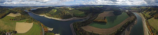
The Hennetalsperre is located in North Rhine-Westphalia in a left side valley of the Ruhr on the northern edge of the Sauerland-Rothaargebirge nature reserve . One kilometer south of the district town of Meschede in the Hochsauerland district, a 60 meter high dam dams the water from the Henne to Hennesee. The operator and owner of the dam is the Ruhr Association based in Essen . With a total storage volume of 39.3 million cubic meters, the Hennetalsperre essentially increases the low water flow of the Ruhr.
history

Between 1901 and 1905, the Upper Ruhr Dam Cooperative built the first dam on the Henne. With a 38 meter high gravity dam made of quarry stone, a storage volume of eleven million cubic meters of water could be created.
In 1927 the former Ruhrtalsperrenverein (RTV) took over the dam in its portfolio. In accordance with its objective, the cooperative had financially supported the construction at the time in order to remedy the water shortage in the lower Ruhr and in the Ruhr area . In 1990 the RTV was merged with the Ruhr Association, which operates wastewater treatment for 2.2 million people in the same association area. With the Hennetalsperre, the Ruhrverband now operates eight of its own dams in the catchment area (see navigation bar under See also ).
However, the carbonated water created pipes and ponors in the limestone-containing, weathered rock bedrock , so that the wall became undermined , i.e. leaky, over the years . The holes in the dam basin, up to 20 meters in size and over 100 meters deep, could not be sealed with clay and in the end more water was lost than the average flowed into the dam. Purposeful operation was no longer possible, and the water flowing under the barrier endangered the stability of the wall. On December 20, 1948, the bottom drains were therefore opened to allow the dam to run dry.
The remains of several villages lie at the bottom of the Hennetalsperre. In very hot summers, such as B. 1976 and 2018, when the water level is extremely low you can see the old bridge of the village of Hellern and parts of the old B 55 . These were flooded after the new dam was built. In addition to Hellern, the towns of Mielinghausen , Enkhausen and Immenhausen were also affected by the expansion of the Hennetalsperre. However, those affected were compensated, e.g. B. with compensation areas on the slopes of the hen.
Characteristic values of the old dam
- above foundation level: 37.9 m
- Crown width: 5.0 m
- Base width: 28.0 m
- Crown height: 303.43 m above sea level NN
- Storage target: 302.43 m above sea level NN
- Storage space: 11 million m³
The new lock
For water management reasons, the RTV could not do without a dam in the Hennetal and therefore looked for a more suitable blocking point. As a result of extensive building geological investigations, a new blocking point, about 200 meters above the old dam, was found, at which the holey subsoil could be sealed within an economically viable framework. After five years of construction, the new Hennetalsperre was put into operation in 1955. A stone embankment with a two-layer surface seal made of asphalt concrete was now chosen as the barrier structure . This seal is supplemented by a bituminous braking zone in the core area of the dam, which is intended to prevent erosion of the dam even if the surface seal is leaky.
As an innovation, the dam was given a control tunnel on the water side at the transition from the surface seal to the valley floor . The 10-meter-wide drainage layers, which are inserted between the two layers of asphalt concrete , flow into this in order to quickly identify and roughly localize any damage to the upper sealing layer. Another special feature is the crown protection structure; a concrete block with a weight of 5,000 t below the structure crown. About 30 meters below the control tunnel runs a second control tunnel, from which the rock area below was sealed with cement injections . The area between the two tunnels was vertically connected by a concrete apron to seal off the particularly permeable area. With a crown length of 376 meters, tunnels and shafts of almost two and a half kilometers run in the underground of the dam .
Compared to the old wall, a 21 meter higher storage target was planned for the dam, which meant that the new dam could receive a significantly larger storage space of 38.4 million cubic meters. This means that the storage volume is greater than the annual average that flows into the dam from the catchment area. Such reservoirs are known as multi-year reservoirs because they take more than a year to completely fill.
To improve the annual performance, the RTV built a bypass system between 1955 and 1957, through which additional water from the eastern neighboring valleys of Brabecke and Kleiner Henne is fed into the new dam. The extraction is controlled automatically and leaves sufficient water in the stream sections below. This water is fed through the second inlet of the barrier, the Horbach.
Operating facilities
.jpg)
At the inlet of the Henne in the dam, the RTV built a preliminary basin near Mielinghausen to hold back the impurities carried in the inflow. The permanent damming in the forecourt also improves the visual impression in the area of the damming root , which is otherwise heavily influenced by falling dry due to the fluctuating water levels . In addition, a pre-basin is easier to empty and remove the deposited substances.
The flood relief structure is located on the right bank in front of the dam crest . This prevents water that cannot be stored from flowing over the dam crest and being discharged through it without damage. The structure has a solid weir made of reinforced concrete with a crown length of 33 meters parallel to the bank . A lowerable fish- bellied flap is arranged at the front of the overflow structure in order to be able to regulate the amount of water somewhat. On the air side of the dam, the structure opens into a chute , at the lower end of which an energy conversion structure dampens the roaring gush of water. The channel is designed for a flow rate of a maximum of 42 cubic meters per second.
Two bottom outlets are available for drawing off water and, if necessary, emptying it. The power plant is connected to the left outlet, and the volume is regulated via its actuating devices. In the second line, a needle valve takes over the targeted setting of a flow rate . Both bottom outlets have a maximum capacity of 25 cubic meters per second each.
During the renovation of the operating facilities in 2001, the locking devices in the bottom outlets were replaced. A plunger valve and a butterfly valve, which had been in operation since 1955, were erected as a technical monument near the top of the dam on the left bank. An information board clearly describes how it works.
Water use
The main purpose of the water reservoir is to provide supplementary water for water consumption in the middle and lower Ruhr. The extraction of Ruhr water and treatment to drinking water, which is diverted to other catchment areas after consumption, creates a deficit in the Ruhr water supply that must be compensated for. The central control of the water delivery is carried out by the dam control center of the Ruhr Association in Essen.
Another task of the barrier is flood protection . In times of high precipitation or in thaws with melting snow , the flood peaks can be alleviated. A flood protection room must therefore be kept free in winter .
The water level difference at the dam and the ongoing release of water is used by a hydroelectric power station. With a usable gradient of 56 meters, two Francis turbines can produce an annual average of 5.3 GWh of electricity. The larger turbine has a capacity of 3.6 cubic meters per second and an output of 1400 kW. The smaller one can use 1.6 cubic meters per second with an output of 600 kW. The power plant is operated by Lister- und Lennekraftwerke GmbH in Olpe, a 100 percent subsidiary of the Ruhr Association.
The Hochsauerland Water GmbH built directly below the dam, a new waterworks and removes water from the bottom outlet pipes. Since June 2016, reservoir water has been processed into drinking water and fed into the supply network. As a special feature, the waterworks and the associated pumping stations can be supplied directly from the nearby power station. The completely independent power supply is cleanly separated from the actual power grid and ensures the water supply of the connected households with drinking water even in the event of a complete blackout .
Regional 2013

As part of the Regionale 2013 , a structural funding program for the newly founded region of South Westphalia , various measures to improve the quality of life and to cope with the consequences of climate change were implemented with the project “Sauerland Lakes: Hennesee” in the vicinity of the Hennetalsperre. The renaturation of the Henne below the Hennedamm and a connection of the dam to the city center of Meschede through the so-called Henne-Boulevard were carried out. During the three-year term of the funding program, the so-called Himmelstreppe was built in May 2015 , which leads from the foot of the dam straight up in 333 steel steps to the top of the dam. After a height difference of 60 meters, it opens into a viewing platform that protrudes around eight meters towards the air.
Industrial Heritage Route
The Hennetalsperre is part of the route of industrial culture . It is actually a network of different themed routes to individual areas of industrial development over the past centuries. Theme route 12 deals with the route of industrial culture - past and present of the Ruhr , in which the Hennetalsperre is listed.
Leisure time
.jpg)
- Bathing and diving : There are two large, free bathing areas at the dam. The bathing bay or Berghauser Bucht in the northwest of the lake opposite the dam is used primarily by locals and day visitors . The DLRG also has its guard station here. After registering with the DLRG, you can dive to a depth of more than 30 meters between the landing stages and the bathing area. Fixed changing rooms and showers are located on the expansive lawn of the bathing bay. In addition to beach volleyball , stand-up paddling can also be practiced for a fee. A second bathing area is the beach near the holiday home area in Mielinghausen on the eastern side of the lake at the level of the Vordamm. Outside the marked bathing areas, access to the water is not permitted for safety reasons.
- Rowing and sailing : The Berghauser Bucht is home to the Meschede rowing club , which was particularly successful in the early 1990s , and the Hennesee eV Meschede sailing club , which has existed since 1967 . There are two other sailing clubs in the south of the lake with the Enkhausen sailing club and the Südstrand yacht club . There are also other water sports options, such as B. Stand up paddling .
- Boat tours and bus : The motor ship “MS Hennesee” runs on the Hennesee from Easter to the end of October between the Welcome Hotel in the north and the holiday home area Mielinghausen in the south. The hourly route has a demand point on the eastern edge of the path. The ship is 32.5 meters long and 6.10 meters wide. With a depth of one meter, it offers space for 400 people. The S70 bus runs between Meschede and Eslohe and can be used for the outward and / or return journey. The line has several stops in the Hennesees area. A combination of hike / boat / bus is also possible.
- Fishing : the anglers sit much quieter and more inconspicuously in their small boats or on land in the many bays of the Hennesees. The Sauerlandia fishing club, the oldest local club, was founded in 1938. Non-members, e.g. B. tourists, have the opportunity to purchase a day ticket.
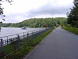
- Hiking : Hikers have the opportunity to completely walk around the Hennesee. While the eastern bank offers an asphalt, car-free hiking and cycling path, on the western bank there is sometimes only the roadside or cycling path right next to the sometimes heavily traveled B55. Only shortly before reaching Berghauser Bucht is an asphalt hiking / cycling path available again. On the east side, the hike can be interrupted with a visit to the sensory path . There is also the option of leaving the hiking route approximately after completing the first third in the direction of an inn in the fields near Remblinghausen. Another good hiking option is the approach from Meschede through the Hennepark and Henneauen. The ascent to the dam can then either take place via the heavenly stairs or via a serpentine hiking and cycling path. People who only want to use the Hennesee for a walk can start at one of the parking lots on the B55 in the Berghauser Bucht area and walk along the lake on what is certainly the most varied and touristic section of the hiking trail up to the dam with its viewing platform.
- Dining and parking : In the Hennesees area there are several hotels and restaurants on the B55, three of which have direct lake access. Another restaurant is located at the foothills in Mielinghausen in the area of the holiday home area. In addition, drinks and sweets are available for purchase on summer days at the kiosk and in the restaurant on Hennesee, at the tennis courts, right near the dam. There are limited parking spaces available at the catering establishments. Otherwise there are several parking bays along the B55. A large car park has been created near Berghauser Bay. At the southern end you can park in the area of the Mielinghauser holiday home area and at the campsite. All parking spaces at Hennesee can currently be used without fees or time restrictions.
photos
The Hennesee is only half full (2016)

Southern part of the Hennesees

Dried out Hennesee in September 1976
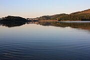
The Hennesee seen from the bathing bay, in the background parts of the city of Meschede
On today's dam

Autumn at the Hennesee

View from the ridge on the width of the Hennesee

.jpg)


See also
Web links
- Dam control center at the Ruhrverband Essen
- Lister- und Lennekraftwerke GmbH
- Hennesee passenger shipping
- Hennesee Tourist Sauerland
- Hennesee waterworks
- Description of all locations on this themed route as part of the Route of Industrial Culture
Individual evidence
- ↑ a b c d The development of the Hennetalsperre. Retrieved May 21, 2020 .
- ↑ a b c d e Information about the Hennetalsperre. Retrieved May 21, 2020 .
- ↑ Even with a "blackout" drinking water can flow to: LLK.de
- ^ Swimming in Hennesee. Retrieved May 21, 2020 .
- ↑ Sailing on the Hennesee. Retrieved May 21, 2020 .
- ↑ Hennesee boat tours. Retrieved May 21, 2020 .
- ↑ Fishing on the Hennesee. Retrieved May 21, 2020 .
- ↑ Hiking around the Hennesee. Retrieved May 21, 2020 .
Visitor center and anchor points (from west to east): Museum of German Inland Shipping | Inner harbor Duisburg | LVR Industrial Museum Oberhausen | Landscape Park Duisburg-Nord | Gasometer Oberhausen | Aquarius Water Museum | St. Antony Hut | Villa Huegel | Nordsternpark | Zeche Zollverein World Heritage Site and Zollverein Coking Plant | Ewald colliery | Marl Chemical Park | Railway Museum Bochum-Dahlhausen | Henrichshütte | Centennial Hall Bochum | Recklinghausen substation | German Mining Museum | Nightingale colliery | Henrichenburg ship lift | DASA | Hansa coking plant | Zeche Zollern II / IV | Hohenhof | Hagen Open Air Museum | Lindenbrauerei Unna | Maximilian Park Hamm
Themed routes (in ascending order by number): 1. Duisburg: City and Harbor | 2. Industrial cultural landscape Zollverein | 3. Duisburg: industrial culture on the Rhine | 4. Oberhausen: Industry makes the city | 5. Krupp and the city of Essen | 6. Dortmund: triad coal, steel and beer | 7. Industrial culture on the Lippe | 8. Erzbahn-Emscherbruch | 9. Industrial culture at Volme and Ennepe | 10. Brine, steam and coal | 11. Early industrialization | 12. The past and present of the Ruhr | 13. On the way to the blue Emscher | 14. Canals and shipping | 15. Lanes in the area | 16. Westphalian mining route | 17. Rhenish mining route | 18. Chemistry, Glass and Energy | 19. Workers' settlements | 20. Entrepreneur villas | 21. Bread, grain and beer | 22. Myth of the Ruhr Area | 23. Parks and Gardens | 24. Industrial nature | 25. Panoramas and Landmarks | 26. Sacred buildings | 27. Iron & Steel | 28. Water: works, towers and turbines | 29. Bochum - industrial culture in the heart of the district | 30. Gelsenkirchen | 31. Industrial Culture and Bauhaus Route | by bike

Ruhrquelle |
Ramsbeck visitor mine |
Hennetalsperre |
Biggetalsperre |
Möhnetalsperre |
Sorpe dam |
Wickede run-of-river power plant |
Run-of-river power station Warm |
Schwitten run-of-river power plant |
Warm waterworks |
Upper Ruhr Valley Railway |
Chainsmith Museum |
Information center aqua publik |
Rohrmeisterei Schwerte |
Ruhr flood bridge Schwerte-Ergste |
Westhofen pumping station |
Bushmill |
Hohensyburg ![]() |
Pumped storage power plant Koepchenwerk |
Hengsteysee |
Herdecke energy industry hiking trail |
Herdecke Ruhr Viaduct |
Castle weather |
Harkort power plant |
Volmarstein community waterworks |
Villa Bönnhoff |
House Schede |
Schlebuscher Erbstollen |
Bommerholz water tower |
Mountain monument on the Hohenstein
|
Pumped storage power plant Koepchenwerk |
Hengsteysee |
Herdecke energy industry hiking trail |
Herdecke Ruhr Viaduct |
Castle weather |
Harkort power plant |
Volmarstein community waterworks |
Villa Bönnhoff |
House Schede |
Schlebuscher Erbstollen |
Bommerholz water tower |
Mountain monument on the Hohenstein ![]() |
Hohenstein hydropower plant |
Ruhr Viaduct Witten |
Steel hammer Bommern |
Mine and field railway museum Zeche Theresia |
Nightingale colliery |
Nightingale and Nightingale Bridge coal defeat |
Villa Friedrich Lohmann Sr. |
Villa Gustav Lohmann |
Villa Friedrich Lohmann jun. |
Villa Albert Lohmann |
House Berger |
Verbund waterworks Witten |
Stainless steel works Witten |
Herbede Ruhr lock |
Sunshine private distillery |
Stainless steel factory Lohmann |
Kemnader See |
Bridge Keeper's House and Lake Bridge |
Blankenstein lock and Stiepel waterworks |
Punching machine |
City Museum Hattingen |
Henrichshütte |
Ruhr Valley Railway |
Birschel mill |
House Weile and Gahlener Kohlenweg |
Towpath below the Isenberg |
Dahlhausen floating bridge |
Dahlhausen lock |
Mining Trail Dahlhausen |
Railway Museum Bochum
|
Hohenstein hydropower plant |
Ruhr Viaduct Witten |
Steel hammer Bommern |
Mine and field railway museum Zeche Theresia |
Nightingale colliery |
Nightingale and Nightingale Bridge coal defeat |
Villa Friedrich Lohmann Sr. |
Villa Gustav Lohmann |
Villa Friedrich Lohmann jun. |
Villa Albert Lohmann |
House Berger |
Verbund waterworks Witten |
Stainless steel works Witten |
Herbede Ruhr lock |
Sunshine private distillery |
Stainless steel factory Lohmann |
Kemnader See |
Bridge Keeper's House and Lake Bridge |
Blankenstein lock and Stiepel waterworks |
Punching machine |
City Museum Hattingen |
Henrichshütte |
Ruhr Valley Railway |
Birschel mill |
House Weile and Gahlener Kohlenweg |
Towpath below the Isenberg |
Dahlhausen floating bridge |
Dahlhausen lock |
Mining Trail Dahlhausen |
Railway Museum Bochum ![]() |
Dahlhausen railway station |
Villa Vogelsang |
Horster mill |
Horst lock |
Well-Safe Colliery |
Holteyer Harbor |
Dinnendahl factory | Historic sewage treatment plant Rellinghausen |
Heinrich Colliery |
Kupferdreh station and Hespertalbahn museum railway |
Deilbachtal cultural landscape with a copper hammer , geological outcrop on the Leberhofer Strasse , Eisenhammer , Deilmann farm , Deiler mill , dog bridge , Prinz-Wilhelm-Bahn , ring kiln brickworks , Victoria colliery |
Baldeneysee |
Carl Funke colliery |
Villa Huegel |
Villa Werden |
Neukircher lock |
Become an abbey |
Paper mill lock |
Kettwig reservoir |
Run-of-river power station and Kettwig lock |
Scheidt's halls |
Kettwig railway bridge |
Landsberg Castle |
Saarn Monastery |
Leather and tanning museum in the Abel leather factory |
Villa Joseph Thyssen |
J. Caspar Troost textile factory |
Mülheim Ruhr lock and Mülheim water station |
Run-of-river power plant Kahlenberg |
RWW Headquarters |
City viaduct and Ruhr bridge Mülheim |
Roundhouse Mülheim and Camera Obscura |
Mannesmannröhren-Werke |
Friedrich Wilhelms-Hütte |
Aquarius Water Museum |
Rhine-Ruhr port of Mülheim |
Raffelberg hydropower plant |
Raffelberg saltwater pool |
Ruhrschleuse Duisburg and Ruhrwehr |
Inner harbor Duisburg |
Museum of German Inland Shipping
|
Dahlhausen railway station |
Villa Vogelsang |
Horster mill |
Horst lock |
Well-Safe Colliery |
Holteyer Harbor |
Dinnendahl factory | Historic sewage treatment plant Rellinghausen |
Heinrich Colliery |
Kupferdreh station and Hespertalbahn museum railway |
Deilbachtal cultural landscape with a copper hammer , geological outcrop on the Leberhofer Strasse , Eisenhammer , Deilmann farm , Deiler mill , dog bridge , Prinz-Wilhelm-Bahn , ring kiln brickworks , Victoria colliery |
Baldeneysee |
Carl Funke colliery |
Villa Huegel |
Villa Werden |
Neukircher lock |
Become an abbey |
Paper mill lock |
Kettwig reservoir |
Run-of-river power station and Kettwig lock |
Scheidt's halls |
Kettwig railway bridge |
Landsberg Castle |
Saarn Monastery |
Leather and tanning museum in the Abel leather factory |
Villa Joseph Thyssen |
J. Caspar Troost textile factory |
Mülheim Ruhr lock and Mülheim water station |
Run-of-river power plant Kahlenberg |
RWW Headquarters |
City viaduct and Ruhr bridge Mülheim |
Roundhouse Mülheim and Camera Obscura |
Mannesmannröhren-Werke |
Friedrich Wilhelms-Hütte |
Aquarius Water Museum |
Rhine-Ruhr port of Mülheim |
Raffelberg hydropower plant |
Raffelberg saltwater pool |
Ruhrschleuse Duisburg and Ruhrwehr |
Inner harbor Duisburg |
Museum of German Inland Shipping ![]() |
Haniel Museum |
Rhine orange
|
Haniel Museum |
Rhine orange