Ruhrkopf
| Ruhrkopf | ||
|---|---|---|
| height | 696.3 m above sea level NHN | |
| location | near Elkeringhausen ; Hochsauerlandkreis , North Rhine-Westphalia ( Germany ) | |
| Mountains | Rothaar Mountains | |
| Dominance | 0.63 km → Westgipfel Böhl | |
| Notch height | 22.6 m ↓ to the Dumel | |
| Coordinates | 51 ° 12 '43 " N , 8 ° 33' 16" E | |
|
|
||
| particularities | Ruhr spring | |


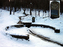
The Ruhrkopf near Elkeringhausen in the North Rhine-Westphalian Hochsauerlandkreis is 696.3 m above sea level. NHN high mountain of the Rothaargebirge . The Ruhr spring lies on the mountain .
geography
location
The Ruhrkopf is located in the north of the Rothaar Mountains in the Sauerland-Rothaar Mountains Nature Park . Its summit rises about 3 km northeast of Winterberg and about 1.5 km (depending on the beeline ) northwest of its district Elkeringhausen . The mountain is part of the Winterberger plateau , which is generally over 600 m high , so that its summit, hidden in the forest, can only be recognized as a gently rising crest. At its northeast slope is at 666.5 m height Ruhrquelle as the origin of the Rhine -Nebenflusses Ruhr , and its southeast flank falls into the valley of the Eder -Zuflusses Orke from. The protected landscape component of the source region Kohlseifen is also located on the mountain .
Natural allocation
The Ruhrkopf belongs to the natural spatial main unit group Süderbergland (No. 33) in the main unit Rothaargebirge (with Hochsauerland ) (333) and in the subunit Winterberger Hochland (333.5) to the natural area Harfeld (Winterberger Hochmulde) (333.56).
Rhine-Weser watershed
The long Rhine-Weser watershed runs over the Ruhrkopf : while the Ruhr flows westwards and finally flows into the Rhine , the water from the short streams that arise on the south-eastern slope of the mountain flows into the Orke . This in turn rises a little further east on the Reetsberg and initially runs in a westerly direction, but then in an easterly direction into the Eder , whose water flows through the Fulda into the Weser .
Recreational area
The approximately 240 km long Ruhrhöhenweg , a hiking trail of the Sauerland Mountain Association , starts northeast below the Ruhrkopf and leads from the Ruhrquelle along the Ruhr to its confluence with the Lower Rhine near Duisburg .
The Küstelberg - Winterberg section of the approximately 154 km long Rothaarsteig , a hiking trail that mainly runs along the main ridge of the Rothaargebirge, leads past the Ruhrkopf and its source . There are two ski lifts and ski slopes on the mountain .
Individual evidence
- ↑ a b Topographical Information Management, Cologne District Government, Department GEObasis NRW ( Notes )
- ↑ Martin Bürgener: Geographical Land Survey: The natural spatial units on sheet 111 Arolsen. Federal Institute for Regional Studies, Bad Godesberg 1963. → Online map (PDF; 4.1 MB)
