Ruhrhöhenweg
| Ruhr height hiking trail | |
|---|---|

|
|
| Data | |
| length | 240 km |
| Supervised by | Sauerland Mountain Association |
| Markers |
(White XR on black mirror) |
| Starting point | Source of the Ruhr near Winterberg 51 ° 12 ′ 49 ″ N , 8 ° 33 ′ 30 ″ E |
| Target point | Estuary in the Lower Rhine near Duisburg 51 ° 27 ′ 3 ″ N , 6 ° 43 ′ 23 ″ E |
| Type | trail |
| Height difference | 652 m |
| The highest point | 672 m |
| Lowest point | 20 m |
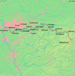
The Ruhrhöhenweg is a 240 km long hiking trail established by the Sauerland Mountain Association (SGV) in 1975 from the source of the Ruhr near Winterberg to its confluence with the Lower Rhine near Duisburg . The path rarely runs directly on the bank, but rather follows the river in the neighboring hills and mountains of the Ruhr Valley.
status
From the source the path leads via Olsberg , Meschede , Arnsberg , Menden , Iserlohn - Sümmern , Schwerte - Ergste , Hohensyburg , Hattingen - Blankenstein , Essen-Steele past the Baldeneysee via Essen-Werden , Mülheim-Mintard and the Duisburg Zoo to Ruhr estuary near Duisburg-Neuenkamp.
The hiking trail falls into the category of the main hiking trails of the SGV and, like its other main hiking trails, has the white St. Andrew's cross X as a signpost , extended by the letter R at intersections.
In 2012, the SGV decided to abandon the Ruhrhöhenweg along with other main hiking trails and no longer mark them. In 2013 the SGV announced that due to the historical importance of the Ruhrhöhenweg this path will continue to be used as the main hiking trail.
history
Historically, the Ruhrhöhenweg is based on two paths of the same name of the Ruhr coal district settlement association , the forerunner of the Ruhr regional association , which ran north and south of the Ruhr between Mülheim (Ruhr) and Hagen and Schwerte from the 1930s onwards . These paths had a circle with a vertical line inside as a signpost.

For this reason, there is a paved dirt road called "Ruhrhöhenweg" near Hagen-Vorhalle and also in Wengern south of the Ruhr , although the actual hiking trail is on the opposite bank of the Ruhr. A street name in the Hattingen district of Holthausen is also based on the course of the historic hiking trail. East of the Ratinger district Breitscheid shortly before Mülheim (Ruhr), another dirt road south of the Ruhr has the name "Ruhrhöhenweg" for the same reason .
A small sheet metal sign for the historic northern Ruhrhöhenweg can still be found at Gut Schede today.
In literature and on contemporary hiking maps, the historic Ruhr Höhenwege are documented from the early 1930s to the mid-1970s, and have been in the care of the SGV since the 1950s and are marked with the XR. It was not until 1975 that SGV created today's Ruhrhöhenweg from the source to the mouth, which alternately uses the old routes north and south of the Ruhr in the area of the Ruhr area .
See also
literature
- Bernhard Pollmann: hiking guide Ruhrhöhenweg. Innsbruck 2012, ISBN 978-3-85026-633-8 .
- Heinrich Streich: Ruhrhöhenweg: from the source to the mouth. Strobel-Verlag, Arnsberg 1990, ISBN 3-87793-027-1 .
Web links
- Description of the Ruhrhöhenweg part 2 (Witten - mouth)
- Ruhrhöhenweg in the GPS hiking atlas with OSM map and current GPS data from the SGV's path cadastre
- Stage run over the Ruhrhöhenweg Westdeutsche Allgemeine Zeitung (WAZ) / The West
- SGV statement on the current situation of the main hiking trails on sgv.de.
Individual evidence
- ↑ Final report: Inventory of the main SGV hiking trails
- ^ Karl Kneebusch : Guide through the Sauerland. 23rd edition. Sauerland-Verlag, Iserlohn 1950, DNB 452466156
- ↑ Sauerland. Gebirgs-Verein (Hrsg.): Guide through the main route network in the Sauerland. Sauerland-Verlag, Iserlohn 1952, DNB 451402723 .
- ^ Heinrich Streich: Ruhrhöhenweg. Strobel-Verlag, 1990, ISBN 3-87793-027-1 .