
Wengern
|
Wengern
City of Wetter (Ruhr)
Coordinates: 51 ° 24 ′ 1 ″ N , 7 ° 20 ′ 39 ″ E
|
|
|---|---|
| Height : | 92 (80-214.3) m |
| Area : | 6.89 km² |
| Residents : | 6534 (Jan 2, 2009) |
| Population density : | 949 inhabitants / km² |
| Incorporation : | January 1, 1970 |
| Postal code : | 58300 |
| Area code : | 02335 |
_Stadtteile_-_Wengern.png) Location of Wengern in Wetter (Ruhr)
|
|
 Aerial view of the center of Wengern: the village church can be seen at the bottom right .
|
|
Wengern is a district of Wetter (Ruhr) in the Ennepe-Ruhr district , North Rhine-Westphalia (Germany). Until 1969, the place south of the Ruhr was an independent municipality in the Volmarstein district .
geography
The district corresponds to the district 1350 Wengern , which covers an area of around 6.89 km². Wengern is located in the northwest of the city of Wetter and is surrounded - starting from the north in a clockwise direction - by the Witten districts of Bommern and Annen , the Herdecker districts of Ende and Herdecke, the Wetteraner districts of Volmarstein , Grundschöttel and Esborn and the Witten district of Vormholz .
The highest point in Wengern is a good 214 m above sea level. NN high harrow on the border with Esborn. The lowest point of the district is about 80 m above sea level. NN ( mean water level ) the Ruhr on the border with Witten in the nature reserve Ruhraue Witten-Gedern .
On the city limits of Witten, part of the cross-community nature reserve Elbschebach Witten Bommerholz belongs to the Wengern district along the Elbe . Furthermore, the three landscape protection areas " Bommerholz, Elbschebach, Böllberg, Brunsberg " , " Brasberg, Höstreichberg, Nockenbach, Elbsche, Teimbecke, Lindenbecke, Stollenbach, Schlebuscher Berg " and " Elberg " are partly in Wengern.
history
Wengern was mentioned as Wyngern as early as 800, at the time of Charlemagne . Wengern was first mentioned in a document in 1003.
On January 1, 1970, the incorporation into the city of Wetter (Ruhr) took place through the law for the reorganization of the Ennepe-Ruhr district of December 16, 1969. Up until then, Wengern was a municipality belonging to the Volmarstein department at that time .
Mining history
There were several mines in the Wengeraner area , including a .:
- Zeche Lilie , between Sandberg and Blumental on the border with Esborn
- Markana colliery
Attractions
Wengern has a historic town center with some listed buildings. These include a. the Protestant village church of Wengern , the glue box and Schlucks Hof. In the half-timbered house "Mühlchen" the Henriette Davidis Museum commemorates the cookbook author Henriette Davidis , who was born in Wengern and lived for a while. In the place of the former aristocratic residence, Haus Dönhoff, there is now a listed half-timbered house.
Other structures entered in Wetter's list of monuments are the Elbschetalviadukt , a railway viaduct of the Elbschetalbahn spanning the Elbschetal , and the mouth hole area of the Schlebuscher Erbstollen in the southeast of Wengern.

Gulp's yard
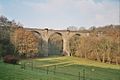
Elbschetal Viaduct


Sports
In Wengern there is a large association called TuS Wengern . The club has around 2000 members and offers various sports. From gymnastics to soccer . In the 2007/2008 season, the team around coach Dean Caschili played in the regional league Season 3 West. The football department was excluded from TuS Wengern 1879 in 2018 and re-established as SC Wengern 5813. This occurs in the district league A Hagen / Ennepe-Ruhr 1.
traffic
The Wengern West station was operated on the route to Schwelm until November 30, 1979 . The “RuhrtalBahn” museum train runs between the Bochum-Dahlhausen Railway Museum and Hagen Hbf via Wengern Ost . A tram line operated in Wengern from June 17, 1920 to 1942. Line 4, operated by Hagener Straßenbahn AG , connected the then independent municipality of Wengern with the cities of Wetter, Herdecke and Hagen . In 1942 only the Wengern − Wetter section was discontinued, and later the section to Herdecke as well.
Planning
The 2015 S-Bahn target network originally planned to build a threading in the direction of Witten behind the Wetter (Ruhr) stop in order to allow the S-Bahn to run from here to the other side of the Ruhr, where they will take the reactivated stops at Wetter-Wengern Ost and Witten-Bommern Höhe were to serve. Wetter (Ruhr) would thus become a hub station. After Oliver Wittke took office in 2005, however, all target agreements were reassessed. The necessary new Ruhr bridge was rejected, so that the S-Bahn continues to run on the traditional right side of the river.
Personalities
People born in Wengern:
- Henriette Davidis (1801–1876), cookbook author
- Ernst Diepschlag (1885–1953), metallurgist and university professor
- Regina van Dinther (* 1958), politician, former President of the State Parliament of North Rhine-Westphalia
- Gustav Kiepenheuer (1880–1949), publisher
- Rudolf Klostermann (1828–1886), lawyer
- Adelbert Natorp (1826–1891), theologian and writer
- Gustav Natorp (1824–1891), teacher, mining official and politician
- Eduard Schulte (1817–1890), art dealer and gallery owner in Düsseldorf, Cologne and Berlin
People who worked in Wengern:
- Heinrich Kositzki (1904–1972), politician, former mayor of Wengern
- Alfred Ernst von Niessen (1901–1978), engineer and shovel manufacturer who died in Wengern, lived in the village for a few years
- Karsten Rudolph (* 1962), politician, former chairman of the local SPD association in Wengern
Web links
Individual evidence
- ^ City of Wetter (Ruhr): Demography Report 2009 . P. 6 (database: population registration data as of January 2, 2009)
- ^ Ennepe-Ruhr-Kreis: Automated real estate book : List of parcels. (PDF; 14 kB) (as of January 1, 2007)
- ↑ a b Topographical Information Management, Cologne District Government, Department GEObasis NRW ( Notes )
- ↑ No individual proof
- ↑ Martin Bünermann: The communities of the first reorganization program in North Rhine-Westphalia . Deutscher Gemeindeverlag, Cologne 1970, p. 113 .
- ↑ Law on the reorganization of the Ennepe-Ruhr district, § 3 paragraph 1
- ↑ Archived copy ( memento of the original from March 21, 2009 in the Internet Archive ) Info: The archive link was inserted automatically and has not yet been checked. Please check the original and archive link according to the instructions and then remove this notice.