Compass (Rothaargebirge)
| compass | ||
|---|---|---|
|
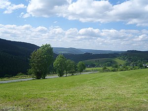
To the left of the central Lahnhelle in the picture you can see the summit area of the Kompass, to the right the Jagdberg |
||
| height | 694.1 m above sea level NHN | |
| location | near Heiligenborn ; District of Siegen-Wittgenstein and Lahn-Dill district ; North Rhine-Westphalia and Hesse ( Germany ) | |
| Mountains | Rothaar Mountains | |
| Dominance | 21.7 km → Hohe Hessel | |
| Notch height | 127.7 m ↓ north of the Lützel settlement , near the junction of the An den weiß Steinen road from Eisenstraße | |
| Coordinates | 50 ° 53 '10 " N , 8 ° 17' 26" E | |
|
|
||
| particularities | highest mountain in the urban area of Bad Laasphe | |
The compass at Heiligenborn in the Siegen-Wittgenstein district , North Rhine-Westphalia , is 694.1 m above sea level. NHN high mountain of the Rothaargebirge ; while the mountain peak is in Westphalia , the south to south-west flank is in the Lahn-Dill district in central Hesse . It is the highest of the southern elevations of the mountains and the highest mountain in the urban area of Bad Laasphe .
geography
location
The compass is located in the south of the Rothaargebirge 1.1 km southeast of Heiligenborn , a small southwestern part of Bad Laasphe. It rises in the southern part of the Natural Park Sauerland Rothaar , said the district of 4.6 km east-southeast town of Bad Laaspher district Fischelbach belonging mountaintop 400 meters north of the border with the Central Hesse Lahn-Dill just with the local village Rittershausen is. Other villages and hamlets around the mountain are Bernshausen and Lindenfeld in the northeast and Sohl in the south-southeast. The western neighbor of the wooded compass is the Jagdberg ( 676.3 m ) belonging to Netphen and 1.2 km away as the crow flies .
Natural allocation
The compass belongs to the natural spatial main unit group Süderbergland (No. 33) in the main unit Rothaargebirge (with Hochsauerland ) (333) and in the subunit Dill-Lahn-Eder source area (333.0) to the natural area Ederkopf-Lahnkopf-Ridge (333.01). Its southern slope is part of the Kalteiche natural area (with Haincher Höhe) (333.00).
Flowing waters
These rivers arise on the flanks of the compass - with the source height in meters (m) above sea level, the distance to the top of the mountain in meters and the length of the water in kilometers (km):
- Bernshaeuser Bach ( Bernshaeuser Water ; approx. 595 m ; 725 m northeast; 3.8 km), Banfe tributary
- Gonderbach (approx. 655 m ; 340 m east-northeast; 3.7 km), Banfe tributary
- Ilse ( Ilsequelle ; 608.2 m ; 325 m west-northwest; 8.7 km), Lahn tributary
- Sohler Bach ( Fischelbach ; approx. 575 m ; 1.3 km south-southeast; 5.6 km), Banfe tributary
Mountain height
About 105 m southwest of the compass summit, a marker stone protruding about 20 cm above the ground is located at the point that is recorded in the city map of Bad Laasphe as a compass - highest elevation in the city area and, for example, there at 693.9 m , a trigonometric one Point with the height indication 694.1 m .
Self-reliance
At 694.1 m high, the compass is 18.5 m higher than its better-known western neighbor, Jagdberg. The gap between the two peaks is 646.3 m. Its dominance is around 21.7 km and extends in a north-northwest direction to the flanks of the 743.6 m high Hohen Hessel .
Protected areas
The compass is located in the Bad Laasphe landscape protection area ( CDDA no. 319747; designated 1987; 123.11 km² in size); to the west, in the direction of the Jagdberg , is the LSG community of Netphen (CDDA no. 321048; 1987; 117.6 km²). To the south of the summit region is the Hauberge bird sanctuary near Haiger (VSG no. 5115-401; 76.86 km²), in which parts of the fauna-flora-habitat area Dietzhölztal near Rittershausen (FFH no. 5115-303; 1, 56 km²).
Traffic and walking
The roads that lead close to the compass include the district road 17 , which runs a little west of the mountain and near Lahnhof from the Eisenstrasse of the Rothaargebirge , a former trade and long-distance road, to Heiligenborn and then further past Lindenfeld to Banfe , as well as spur roads the K 38, which ends in Bernshausen , and the K 36, which leads to Sohl . Almost 60 m north-west past the mountain summit runs in a north-east-south-west direction, an old coal road that branches off to the west of the iron road and now serves as a forest and hiking trail that opens up the mountain. Just northwest past the compass of the local leading Ilse source passing Rothaarsteig .
Individual evidence
- ↑ a b c d Topographical Information Management, Cologne District Government, Department GEObasis NRW ( information )
- ↑ Heinz Fischer: Geographical Land Survey: The natural spatial units on sheet 124 Siegen. Federal Institute for Regional Studies, Bad Godesberg 1972. → Online map (PDF; 4.1 MB)
- ^ Compass - Highest point in the urban area in the city map of Bad Laasphe (see near Heiligenborn), on www.unser-stadtplan.de
- ↑ German basic map
- ↑ Map services of the Federal Agency for Nature Conservation ( information )

