Request
|
Request
City of Bad Laasphe
Coordinates: 50 ° 54 ′ 51 ″ N , 8 ° 21 ′ 6 ″ E
|
|
|---|---|
| Height : | 370 m |
| Area : | 15.32 km² |
| Residents : | 1500 |
| Population density : | 98 inhabitants / km² |
| Incorporation : | 1st January 1975 |
| Postal code : | 57334 |
| Area code : | 02752 |
|
City structure of Bad Laasphe with districts
|
|
|
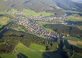
Aerial view of Banfe
|
|
Banfe is a district of Bad Laasphe in the North Rhine-Westphalian district of Siegen-Wittgenstein ( Germany ). The village on the Lahn tributary of Banfe has around 1500 inhabitants.
Geographical location
Banfe is located in the southern Wittgensteiner Land , about 4.5 km west-southwest of the core town of Bad Laasphe. Neighboring towns are, starting from the north clockwise: Herbertshausen , Laaspherhütte , Bad Laasphe, Hesselbach , Bernshausen and Lindenfeld . The village is surrounded in the east by the Wartholz-, Katzen- and Hasenkopf, in the southeast by the small and large Ahlertsberg and in the west by the Inthalberg. In the center of the village, the Auerbach and then the Godelsbach flow into the Banfe .
history
Banfe was first mentioned in a document in 1268. Local researchers agree that Banfe is older - and is even one of the oldest settlements in the former Wittgenstein district. The name Banfe can be derived from Celtic and has the meaning of "murder water". Numerous archaeological finds, such as the stone ax from the "Wachtel" (forest in Banfe) as well as pot and bowl fragments from the "Auerbach" flowing through the village, point to an early settlement. The pieces found are proof that Banfe was settled 4000 and 2000 years ago.
Until 1806, Banfe belongs to the County of Sayn-Wittgenstein-Hohenstein . From 1806 to 1816 it belonged to Hessen-Darmstadt, since 1816 to the Prussian province of Westphalia .
Until 1844, Banfe formed the Schulzen district of the same name for the administration of the places Banfe, Herbertshausen and Heiligenborn . Since 1845, the newly established Banfe Office has included the villages of the former Schulzen district and also Fischelbach , Hesselbach, Bernshausen, Saßmannshausen , Bermershausen , Holzhausen , Puderbach , Niederlaasphe and Kunst Wittgenstein .
The former municipality of Banfe has belonged to the town of Bad Laasphe in the Siegen-Wittgenstein district since the Sauerland / Paderborn Act was implemented on January 1, 1975.
Culture and sights
There is a kindergarten and a primary school in Banfe. The building was erected in 1904. The Banfetal Local History Museum was founded in 1965.
Village life is strongly influenced by the associations, including the “Wander- und Heimatfreunde Banfetal e. V. ", which in addition to organizing popular hikes also take responsibility for environmental and landscape conservation, the VfB Banfe, the MGV Banfe, the women's choir Banfe, the counter team" Zur Post ", the Spielmannszug Banfetal, Schützenkameradschaft Banfe 1872 e. V. and others.
church
The church was first mentioned in a document in 1492. The church was built on a small hill between the streams Banfe and Godelsbach. Part of this church collapsed at Easter 1872, which led to the church being closed. In 1876 the construction of the current church began. It was completed in 1877 and consecrated on December 18, 1877. It is the only church in the Wittgenstein parish with two towers ("Banfer Dom"). These two towers on the western side of the building are 20.05 m high.
Sports
A modern artificial turf sports field is located in Banfe.
Economy and Infrastructure
In Banfe, some families still run farming as a sideline . The Walter Klein Wuppertal company has a branch in the town.
care
In 1898 a water pipe is built for Banfe. Electrification began in the village in 1921 .
traffic
The place is on the state road 718 , which joins the federal road 62 a few kilometers east in Bad Laasphe . District road 17 also begins in Banfe and leads to Feudingen or Heiligenborn .
Hesselbach wind farm

Part of the Hesselbach wind farm with eight Vestas V112 wind turbines and a total output of 18 MW has been located in the Banfe district since 2013 .
Web links
- Location description on the Bad Laasphes homepage
- Banfe in the Westphalia Culture Atlas
Individual evidence
- ^ Günther Wrede: Territorial history of the County of Wittgenstein. NG Elwertsche Verlagsbuchhandlung, Marburg 1927, p. 129.
- ^ Federal Statistical Office (ed.): Historical municipality directory for the Federal Republic of Germany. Name, border and key number changes in municipalities, counties and administrative districts from May 27, 1970 to December 31, 1982 . W. Kohlhammer, Stuttgart / Mainz 1983, ISBN 3-17-003263-1 , p. 337 f .
- ↑ Artificial turf pitch. (No longer available online.) Vfb-banfe.de, archived from the original on November 21, 2015 ; accessed on November 11, 2015 . Info: The archive link was inserted automatically and has not yet been checked. Please check the original and archive link according to the instructions and then remove this notice.

