Lenneplatz
|
Lenneplatz
City of Winterberg
Coordinates: 51 ° 10 ′ 14 " N , 8 ° 28 ′ 46" E
|
||
|---|---|---|
| Height : | 735-778 m above sea level NHN | |
| Residents : | 49 (Jun 30, 2019) | |
| Postal code : | 59955 | |
| Area code : | 02981 | |
|
Location of Lenneplätze in Winterberg |
||
|
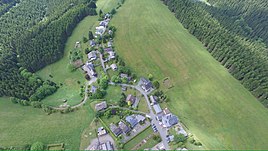
Aerial view of the place
|
||
Lenneplätze is a district of Winterberg in the North Rhine-Westphalian Hochsauerlandkreis in Germany . The village has fewer than 50 inhabitants and is one of the “hilltop villages” of the city.
Geographical location
Lenneplätze is on the main ridge of the Rothaargebirge , over which the Rhine-Weser watershed runs, on the southern slope of the Kahler Asten . It is located about four and a half kilometers (as the crow flies ) southwest of Winterberg city center between the sources and upper reaches of the Lenne (northwest), which rises near the Astengipfels, and the Odeborn (southeast), which flows off the southeast slope of the mountain, at about 735 to 778 m above sea level. NHN . The southern neighbor is the "Höhendorf" Neuastenberg . The Gerkenstein ( 792.7 m above sea level ) lies south of Lenneplätze .
Lenneplätze can be reached on side roads that branch off in Neuastenberg from a common section of federal roads 236 and 480 , which is part of the Hochsauerland-Höhenstraße holiday route and leads from Langewiese through Neuastenberg towards Kahler Asten and Winterberg.
history
On April 1, 1945, Lieutenant General Fritz Bayerlein came in command of the LIII. Army corps with his staff to Lenneplätze. Bayerlein's corps was responsible for the defense in this part of the Ruhr basin . Bayerlein and the other Wehrmacht soldiers fled west on the morning of April 2nd. At 11 a.m. the US Army took the hamlet without a fight . In the afternoon some grenades were fired into the area by German troops from Neuastenberg without hitting. US artillery arrived on April 4th. This shot at targets in the area of Kahler Asten-Altastenberg- Large picture . The bulk of the US troops left Lenneplätze on April 8th.
Until 1974 Lenneplätze belonged to an exclave of the municipality Altastenberg the Office Niedernfeld , Kreis Brilon . As a result of the regional reform, the municipality of Altastenberg was incorporated into the city of Winterberg in the newly formed Hochsauerlandkreis on January 1, 1975.
tourism
Lenneplätze is particularly known for the nearby winter sports facilities - the Postwiesen ski area , the biathlon stadium of the Sport Club Neuastenberg-Langewiese and the indoor go- kart track of the Dorint Hotel in Neuastenberg. From the place on the Rothaarsteig you can see, among other things, the Lennetal .
The house numbering in Lenneplätze is arranged chronologically according to the construction date of the houses.
Web links
Individual evidence
- ↑ City of Winterberg: Winterberg in facts and figures , accessed on December 30, 2019
- ↑ Topographical Information Management, Cologne District Government, Department GEObasis NRW ( Notes )
- ^ Hugo Cramer: The district of Brilon in the Second World War 1939-1945 . Josefs-Druckerei, Bigge 1955, section Altastenberg, district Lenneplätze, p. 106.
- ^ Federal Statistical Office (ed.): Historical municipality directory for the Federal Republic of Germany. Name, border and key number changes in municipalities, counties and administrative districts from May 27, 1970 to December 31, 1982 . W. Kohlhammer, Stuttgart / Mainz 1983, ISBN 3-17-003263-1 , p. 332 .

