Neuastenberg
|
Neuastenberg
City of Winterberg
Coordinates: 51 ° 9 ′ 38 ″ N , 8 ° 29 ′ 0 ″ E
|
||
|---|---|---|
| Height : | 728 (680-780) m | |
| Area : | 2.68 km² | |
| Residents : | 376 (Jun 30, 2019) | |
| Population density : | 140 inhabitants / km² | |
| Incorporation : | 1st January 1975 | |
| Postal code : | 59955 | |
| Area code : | 02981 | |
|
Location of Neuastenberg in Winterberg |
||
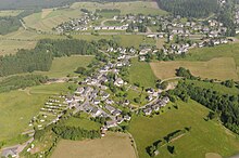
Neuastenberg is a district of Winterberg in the Hochsauerlandkreis , North Rhine-Westphalia , Germany . With a little less than 400 inhabitants, it is the second largest “hill village” in the city.
Geographical location
Neuastenberg lies on the main ridge of the Rothaargebirge , over which the Rhine-Weser watershed runs, on the southern slope of the Kahler Asten . It is located about 5 km (as the crow flies ) southwest of Winterberg city center between the sources and upper reaches of the Lenne (northwest), which rises near the Asten summit, and the Odeborn (southeast), which flows from the southeast slope of the mountain, at around 680 to 780 m above sea level. NN . The neighboring “Höhendörfer” are Lenneplätze and the Langewiese to the southwest . The Gerkenstein ( 792.7 m above sea level ) lies west of Neuastenberg .
Coming from Langewiese, through Neuastenberg, in the direction of Kahler Asten and Winterberg, there is a common section of federal highways 236 and 480 , which is part of the Hochsauerland-Höhenstraße holiday route .
history
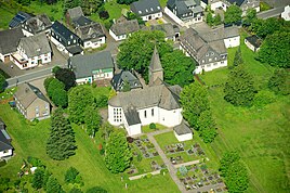
The history of Neuastenberg goes back to the 18th century and is closely linked to the history of Winterberg and Bad Berleburg . It was founded by Count Casimir von Sayn-Wittgenstein-Berleburg . In contrast to the rest of Sayn-Wittgenstein , the village was predominantly of Catholic faith. A first Catholic chapel is mentioned for 1810, but it burned down a few months later. An independent parish was founded in 1876. The Laurentiuskirche is in the village . In the course of the Sauerland / Paderborn law , the Berleburg office was dissolved on January 1, 1975 and the place was incorporated into the town of Winterberg. It is therefore one of the few evangelical places in the Hochsauerlandkreis. From a historical and cultural point of view, Neuastenberg is counted on the outskirts of the Wittgensteiner Land .
FFH area Bergwiesen near Winterberg
The village is largely surrounded by the FFH area Bergwiesen bei Winterberg (DE 4717-305). Most of the Postwiesen ski area is designated as the Postwiese landscape protection area and lean grassland near Neuastenberg and areas north, west and south as the Bergwiesen nature reserve near Neuastenberg , both of which are also part of the FFH area. The FFH area comprises for the most part legally protected biotopes according to § 30 BNatSchG .
tourism
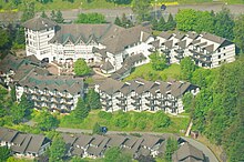
Neuastenberg is best known for its winter sports facilities, including the Postwiesen ski area , the biathlon stadium of the Sport Club Neuastenberg-Langewiese and the indoor go- kart track at the Dorint Hotel . In addition, the West German Winter Sports Museum with adjoining gastronomy was set up in the village on its own initiative . The Rothaarsteig leads through the village .
Individual evidence
- ↑ City of Winterberg: Winterberg in facts and figures , accessed on December 30, 2019
- ↑ Topographical Information Management, Cologne District Government, Department GEObasis NRW ( Notes )
- ↑ Ulf Lückel in Westfälischer Heimatkalender 68th year, published by Westfälischer Heimatbund 2014, p. 31.
- ^ Federal Statistical Office (ed.): Historical municipality directory for the Federal Republic of Germany. Name, border and key number changes in municipalities, counties and administrative districts from May 27, 1970 to December 31, 1982 . W. Kohlhammer, Stuttgart / Mainz 1983, ISBN 3-17-003263-1 , p. 332 .
- ↑ Hochsauerlandkreis - Lower Landscape Authority: Landscape Plan Winterberg (PDF; 1.4 MB). Meschede 2008, pp. 102 ff, 130 ff, 204 ff.


