
Hunau
| Hunau | ||
|---|---|---|
 Hunau near Bad Fredeburg with the Bödefeld telecommunications tower |
||
| height | 818.5 m above sea level NHN | |
| location | between Schmallenberg and Winterberg ; Hochsauerlandkreis , North Rhine-Westphalia ( Germany ) | |
| Mountains | Hunau massif , ( Rothaar Mountains ) | |
| Dominance | 6.9 km → Kahler Asten | |
| Notch height | 139 m ↓ near large picture | |
| Coordinates | 51 ° 12 '38 " N , 8 ° 23' 42" E | |
|
||
| particularities | - Bödefeld telecommunications tower - Bödefeld-Hunau ski area |
|


The Hunau in the Hochsauerland is 818.5 m above sea level. NHN high ridge of the Rothaargebirge , in the area of Schmallenberg with foothills in that of Winterberg in the North Rhine-Westphalian Hochsauerlandkreis . It is the namesake and center of the Hunau natural area , one of the most montane parts of the Rothaargebirge, which clearly extends beyond the ridge of the Hunau.
The Hunau is the location of the Bödefeld telecommunications tower and the Bödefeld-Hunau ski area .
geography
location
The Hunau rises between Siedlinghausen (to Winterberg ) in the northeast and Bad Fredeburg (to Schmallenberg ) in the southwest over a length of about 14 km. Most of it lies in the urban area of Schmallenberg, only its eastern foothills are part of the town of Winterberg. With the main part of the Rothaar it depends on a off-road in the forest on 679.5 m height located notch together, 2.4 km northwest of Altastenberg near the Great little picture is.
The Hunaugipfel is about 10 km northeast of Schmallenberg center, about 6 km east of Bad Fredeburg, 2 km southeast of Osterwald , 4 km south of Bödefeld , 2 km northwest of Rehsiepen and 1.3 km (depending on the beeline ) north of Obersorpe , the all belong to Schmallenberg; about 40 m northeast of the summit is a trigonometric point ( 817.6 m ).
Watershed and rivers
The watershed of Ruhr runs over the Hunau and the gorge leading to the Großer Bildchen in the north and its tributary Lenne in the south. To the north of the mountain arise the Ruhr tributary Valme , its tributaries Brabecke and the Brabecke tributaries Palme and Unvalme , in the east the Neger , in the southeast the Lenne tributary Sorpe , in the south their small tributaries Hunausiepen and Esenbeck and in the west the Lenne tributary Westernah ( Westernahbach ) and the Ruhr tributary Henne .
Natural allocation
The Hunau forms in the natural spatial main unit group Süderbergland (No. 33) in the main unit Rothaargebirge (with Hochsauerland ) (333) and in the subunit Winterberger Hochland (333.5) the natural area Hunau (333.55). The landscape merges to the northwest into the Henneborn valleys and ridge (333.84) and falls to the north into the natural area Bödefelder Mulde (333.80), which also belongs to the subunit Hochsauerländer Schluchtgebirge (333.8) , to the east it leads into the natural area Nordheller Höhen (333.57) over, and to the south it falls into the subunit Lennekessel (333.6). To the south-west it drops significantly to the Fredeburg Chamber (335.1, Sauerland Senken ).
Mountain height
The height of the 818.5 m high Hunau is usually given as around 818 m . About 35 m northeast of the mountain peak, two trigonometric points at 817.6 m and 817.5 m in height are shown on topographic maps directly north and south of the ridge path that runs there . At a gentle bend in this forest path there is an 814.3 m high point around 70 m west of the summit .
Protected areas and raised bogs
On and on the Hunau there are two large nature reserves , Hunau - Langer Back - Heidberg ( CDDA no. 163822; designated 1953; 6.06 km² in size) and Hömberg / Brusenbecke / Eberg / Kalte Spring (CDDA no. 389784; 2008; 3.79 km²), as well as three small nature reserves on and on the western foothills. On the mountain there are also parts of the landscape protection area Rothaargebirge (Hochsauerlandkreis-Teilfläche 1) (CDDA-Nr. 323981; 1994; 140.53 km²) and in the east the LSG part of the city of Winterberg (CDDA-Nr. 325127; 1994; 75, 32 km²). In the east there are also areas of the fauna-flora-habitat area Hunau, Upper Negertal, Renautal and Steinberg (FFH no. 4716-301; 14.98 km²).
The Rauhes Bruch ( 770 m ) and Nasse Wiese ( 750 m ) raised bogs , which are over 8,000 years old , are under nature protection and are the habitat of rare animals and plants on the Hunau .
Telecommunication tower Bödefeld
About 1.3 km west-southwest of the Hunaugipfels is the 1968 inaugurated and 173 m high telecommunications tower Bödefeld as a highly visible landmark and identifying feature of the ridge; the fork in the road immediately north of the tower is at a height of 793.6 m .
Bödefeld-Hunau ski area
The Bödefeld-Hunau ski area supported by the EU structural funding program is located on the northern slope of the Hunau . The mountain station of the longest ski lift is around 480 m west of the Hunaugipfel near Irreplatz ( 799.7 m ) and the valley stations of the three lifts (two parallel and one separate drag lift) in the area near the small palm inflow Rösternaht .
Big picture
The large picture ( called Am Großer Bildchen according to the inscription there ) is a picture of the saint of Jesus Christ set in natural stone , which is located near the transition from the Hunau to the main part of the Rothaargebirge with the natural area Astenberg there at the junction of the K 75 from the L 742 (see section Traffic and Hiking ) stands next to a 699.65 m high point. In front of the image of the saint there are marker stones from local groups of the Sauerland Mountain Association (SGV) and nearby a refuge and the hikers' parking lot Großer Bildchen . Almost 300 m northwest of the road branch there is, away from roads, in the forest at an altitude of 679.5 m , a notch leading northwest to Hunau, over which the Ruhr-Lenne watershed runs.
Traffic and walking
State road 776, which leads from Gellinghausen through Rimberg to Bad Fredeburg , runs northwest past the Hunau . District road 19 branches off from this road near Rimberg , which runs north of the mountain past Osterwald and at the valley station of the Bödefeld-Hunau ski area in a north-east direction to Bödefeld . The L 742 runs south and east past the mountain and runs from Niedersorpe upwards along the Sorpe through Mittelorpe , Obersorpe and Rehsiepen and then downwards along the Neger north-east to Siedlinghausen . From this road branches off at 700 m at the Großer Bildchen, which leads to Altastenberg and ends there. The section of the L 742 running from Siedlinghausen to this junction, which reaches a maximum height of 702.2 m around 65 m northeast of the junction , and the entire K 75 are part of the Hochsauerland-Höhenstraße . There are parking spaces for hikers with marked circular hiking trails in the Hunau area along these streets . In addition, three main hiking routes run by the Sauerland Mountain Association : the Wilhelm-Münker-Weg , the Astenweg and the Hunauweg .
gallery

The Rauhes Bruch raised bog ...
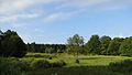
... is over 8000 years old and is 770 m above sea level
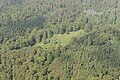
Aerial view:
wet meadow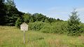
The
wet meadow high moor ...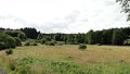
... is the same age and is 750 m above sea level


Individual evidence
- ↑ a b c d e f g h i j k l Topographical Information Management, Cologne District Government, Department GEObasis NRW ( information )
- ↑ Martin Bürgener: Geographical Land Survey: The natural spatial units on sheet 111 Arolsen. Federal Institute for Regional Studies, Bad Godesberg 1963. → Online map (PDF; 4.1 MB)
- ↑ Martin Bürgener: Geographical Land Survey: The natural spatial units on sheet 110 Arnsberg. Federal Institute for Regional Studies, Bad Godesberg 1969. → Online map (PDF; 6.1 MB)
- ↑ a b c Map services of the Federal Agency for Nature Conservation ( information )
- ↑ a b Sign on the wet meadow moor , photo on commons.wikimedia.org
Web links
- Bödefeld-Hunau ski area with webcam , at hunaulift.de