Sauerland sinks
| Sauerland sinks | |||
|---|---|---|---|
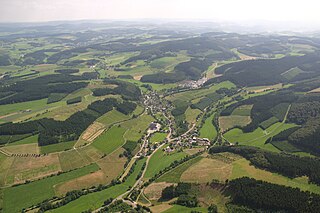
| View of the Sauerland valley near Eslohe - Kückelheim . | |||
| Systematics according to | Handbook of the natural spatial structure of Germany | ||
| Greater region 1st order | Low mountain range threshold | ||
| Greater region 2nd order | Rhenish Slate Mountains | ||
| Main unit group | 33 → Süderbergland |
||
| Natural space |
335 → Sauerland Depression |
||
| Geographical location | |||
| Coordinates | 51 ° 20 '52 " N , 8 ° 10' 29" E | ||
|
|||
| circle | Hochsauerlandkreis , Märkischer Kreis | ||
| state | North Rhine-Westphalia | ||
| Country | Germany | ||
The Sauerland valleys , even internal Auer countries lowering called, are a hilly landscape in the North Rhine-Westphalian Sauerland , stretching from the middle reaches of the Ruhr in Meschede to the southwest to the north of the Biggesee in Attendorn draws. Within the natural spatial main unit group 33 (= D38) Süderbergland the sinks represent the main unit 335.
Geographical location
Despite the majority in the name, the Sauerland depressions are a coherent hilly landscape within which the actual depressions are interrupted by more mountainous mountain ranges. Its area stretches from the upper middle course of the Ruhr near Meschede to the northeast to just before Brilon , while on both sides of the Lennegebirge a western tip stretches as far as Balve and Neuenrade , a southwestern one that crosses Henne , Wenne and Lenne , along the Bigge lower reaches to Attendorn immediately north of the Bigge lake is enough.
In particular, the depressions separate the Rothaargebirge (located to the south) and foothills such as the Saalhauser Mountains from the North Sauerland Oberland in the north and both in turn from the Ebbe-Homert threshold in the west.
Natural structure
The Sauerland depressions are structured as follows:
-
335 Sauerland sinks or Inner Sauerland sinks
- 335.0 Oberruhrgesenke
- 335.1 Fredeburg Chamber
- 335.10 Schmallenberg reasons
- 335.11 Fredeburg hill country
- 335.2–3 Attendorner Mulde
- 335.2 Attendorn-Elsper limestone sinks
- 335.3 Kobbenroder bars
- 335.4 Eslohe-Reister Valley
- 335.5 Mescheder Chamber
- 335.6 Hellefeld Depression (with Hardtberg range)
- Hellefelder Mulde (north)
- Hardberg Range (middle)
- Altenhellefelder Mulde (south)
- Stockumer Mulde (united Mulde in the west)
- 335.7 Oberhönnewinkel
The Oberruhrgesenke accompanies the Ruhr from Olsberg to just above Meschedes . Individual peaks between the river and the up to 744.8 m high Hochsauerländer Schluchtgebirge south of it, in the extreme north of the Rothaargebirge , reach around 600 m . The Mescheder Kammer joins the Ruhr valley as far as immediately below Freienohl .
From the Ruhr valleys, two valleys stretch to the southwest, which enclose the Lennegebirge on both sides:
From the Mescheder Kammer in the Wenne estuary area, the Hellefeld depressions stretch south-west to over the southern end of the Sorpesees near Amecke , to flow into the Oberhönnewinkel , which extends to the valley of the Hönne between Küntrop in the south-west and Beckum to the northeast.
The southern arm of the Sauerland valley, in turn, extends from the junction to the Oberruhrgesenke near Remblinghausen to the north of the Bigge lake near Attendorn , with which it crosses the Lenne valley in particular . Here between the Eslohe-Reister Senke around Eslohe and Reiste and the Attendorn-Elsper Kalksenken in the extreme southwest from north of Cobbenrode to around Elspe the Kobbenroder Riegel with mountains of z. Sometimes over 550 m , but not the heights of the Lennegebirge (up to 656.1 m ) in the northwest and the Saalhauser Berge (up to 688.5 m ) in the southeast.
To the east, the Kobbenroder bolt locks the Fredeburg Chamber around Fredeburg and Schmallenberg , which is bounded in the eastern half by the Rothaar Mountains, which reach 818.5 m on the nearby Hunau, and in the south-west by the Saalhauser Mountains.
Individual evidence
- ^ Emil Meynen , Josef Schmithüsen (Ed.): Handbook of the natural spatial structure of Germany . Federal Institute for Regional Studies, Remagen / Bad Godesberg 1953–1962 (9 deliveries in 8 books, updated map 1: 1,000,000 with main units 1960).
- ↑ Martin Bürgener: Geographical Land Survey: The natural spatial units on sheet 110 Arnsberg. Federal Institute for Regional Studies, Bad Godesberg 1969. → Online map (PDF; 6.1 MB)
- ↑ Martin Bürgener: Geographical Land Survey: The natural spatial units on sheet 111 Arolsen. Federal Institute for Regional Studies, Bad Godesberg 1963. → Online map (PDF; 4.1 MB)
Web links
- Natural area maps from single sheets 1: 200,000 of the Federal Institute for Regional Studies - all units beginning with "335" on sheet 110 - Arnsberg and sheet 111 - Arolsen are relevant here
- BfN

