North Sauerland Oberland
| North Sauerland Oberland | |||
|---|---|---|---|
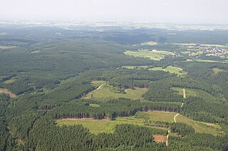
| The Arnsberg Forest in the North Sauerland Oberland near Warstein - Hirschberg | |||
| Systematics according to | Handbook of the natural spatial structure of Germany | ||
| Greater region 1st order | Low mountain range threshold | ||
| Greater region 2nd order | Rhenish Slate Mountains | ||
| Main unit group | 33 → Süderbergland |
||
| Natural space |
334 → North Sauerland Oberland |
||
| Geographical location | |||
| Coordinates | 51 ° 26 '50 " N , 8 ° 8' 18" E | ||
|
|||
| circle | District of Soest , Hochsauerlandkreis | ||
| state | North Rhine-Westphalia | ||
| Country | Germany | ||
The North Sauerland Oberland is a naturally delimited part of the Sauerland in North Rhine-Westphalia that is a maximum of 581.5 m high at the Plackweghöhe in the Plackwald . Within the main unit group 33 ( Süderbergland , Bergisch-Sauerland Mountains ) it forms the main unit 334.
location
The North Sauerland Oberland stretches in a slight curve from Balve to Marsberg . To the north, part of the Hellwegbörden (main unit 542) and thus the Westphalian Bay (main unit group 54) borders in the Haarstrang .
To the south, the Sauerland sinks (335) separate the area from the adjoining Rothaargebirge (with Hochsauerland , 333) and to the southwest from the Lennegebirge (part of the Südsauerländer Bergland , 336 2 ); in the west joins the Lower Sauerland (337 2 ).
The Arnsberger Wald nature park in the knee between the Möhne in the north and the Ruhr region to the south-west forms the (northern) center of the landscape.
Natural structure
The North Sauerland Oberland (order number 334) is structured as follows:
- 334 North Sauerland Oberland
- 334.0 Sundern Forests
- 334.1 Oeventrop Ruhr Valley
- 334.10 Rumbeck slopes
- 334.11 Oeventrop Ruhrtalgrund
- 334.12 Glösingen-Enster slopes (with Wennemer Mark )
- 334.2 Lower Arnsberg Forest
- 334.20 Himmelpforter Möhnetal
- 334.21 Möhnsee area
- 334.3 Upper Arnsberg Forest
- 334.30 Mittelmöhnetal ("Belecker Möhnetal")
- 334.31 Heve-Möhne-Forest
- 334.32 Breitenbruch Forest
- 334.33 Hirschberger nakedness
- 334.34 Kahlenberg heads
- 334.4 Warsteiner hill country
- 334.5 Plackwald (see Plackweghöhe )
- 334.6 Obermöhne and Almewald
- 334.7 Briloner Land (" Briloner plateau ", not congruent with Briloner heights !)
- 334.70 Brilon limestone plates ("Brilon limestone plateau ")
- 334.71 Almer Grund ("Almer Quellgrund")
- 334.72 Madfeld slate floor
- 334.8 Fürstenberg Forest
Landscapes
The Arnsberg Forest Nature Park , which mainly consists of the Arnsberg Forest in the narrower sense with the Möhnesee in the north (west) en, the Plackwald ( Warsteiner Wald ) adjoining it to the southeast and the Warsteiner Hügelland enclosed by both , becomes southwest, beyond the Oeventroper Ruhr valley , continued through the Sundern forests .
To the east, the Obermöhne- and Almewald join the nature park, to the southeast, the Briloner Land. which merges into the Fürstenberg forest with the Aabachsee in the far east .
Waters
- ( Lip )
-
Dysentery
- Wanne (Ruhr inflow at Niedereimer )
- Röhr (left tributary of the Ruhr)
-
Möhne with Möhnesee (right Ruhr tributary)
- Biber (Möhne tributary near Rüthen )
- Glenne (Möhne tributary northwest of Warstein -Kallenhardt, not to be confused with Glenne , a tributary of the Lippe)
-
Wester (Möhne tributary at Belecke )
- Langer Bach (western tributary near Warstein)
- Wideybach (western tributary near Warstein)
- Heve (Möhne tributary, confluence with the southern arm of the Möhnestausees)
See also
Individual evidence
- ↑ E. Meynen and J. Schmithüsen : Handbook of the natural spatial structure of Germany - Federal Institute for Regional Studies, Remagen 1953–1961
- ↑ Martin Bürgener: Geographical Land Survey: The natural spatial units on sheet 110 Arnsberg - Federal Institute for Regional Studies, Bad Godesberg 1969
- ↑ Martin Bürgener: Geographical land survey: The natural space units on sheet 111 Arolsen - Federal Institute for Regional Studies, Bad Godesberg 1963

