Tube (river)
| Tube | ||
| Data | ||
| Water code | DE : 27618 | |
| location | Germany | |
| River system | Rhine | |
| Drain over | Ruhr → Rhine → North Sea | |
| source | at tube spring 51 ° 14 ′ 29 ″ N , 8 ° 2 ′ 31 ″ E |
|
| Source height | 593 m above sea level NHN | |
| muzzle | at Hüsten in the Ruhr Coordinates: 51 ° 26 ′ 4 ″ N , 7 ° 59 ′ 27 ″ E 51 ° 26 ′ 4 ″ N , 7 ° 59 ′ 27 ″ E |
|
| Mouth height | 160 m above sea level NHN | |
| Height difference | 433 m | |
| Bottom slope | 15 ‰ | |
| length | 28.9 km | |
| Catchment area | 203.427 km² | |
| Discharge at the gauge Endorf1 A Eo : 26.1 km² Location: 19.3 km above the mouth |
NNQ (06.10.2001) MNQ 1961/2010 MQ 1961/2010 Mq 1961/2010 MHQ 1961/2010 HHQ (31.12.1986) |
0 l / s 25 l / s 220 l / s 8.4 l / (s km²) 4.38 m³ / s 9.73 m³ / s |
| Discharge at the Müschede A Eo gauge : 195 km² Location: 3.31 km above the mouth |
MNQ 1985/2015 MQ 1985/2015 Mq 1985/2015 MHQ 1985/2015 |
846 l / s 3.42 m³ / s 17.5 l / (s km²) 24.8 m³ / s |
|
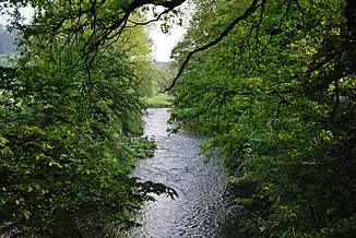
Röhr in coughs |
||
|
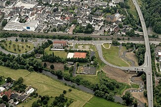
Confluence of the renatured tube into the Ruhr |
||
The Röhr is a 28.9 km long left tributary of the Ruhr in the North Rhine-Westphalian Sauerland ( Germany ).
geography
course
The Röhr rises on the southern outskirts of Röhrenspring , a district of Sundern , at an altitude of 597 m above sea level. NHN . From here it flows primarily in a northerly direction. On its way it flows through the already mentioned Röhrenspring, Sundern, Hachen , Müschede and ends at Hüsten at 161 m above sea level. NHN on the left into the Ruhr.
On the 28.9 km long path of the Röhr there is a difference in altitude of 436 m, which corresponds to a mean bed gradient of 15.1 ‰. The most important tributary is the Sorpe with the Sorpe dam . At the Endorfer Mühle , water from the pipe can be cut off into the Sorpe dam via a tunnel system (Settmecke tunnel 7.2 km).
Catchment area
The 203.43 km² catchment area of the Röhr is drained into the North Sea via the Ruhr and Rhine .
The catchment area has the following usage structure:
- 6.3% - settlement and traffic areas
- 0.3% - industrial and commercial land
- 1.6% - water areas
- 59.4% - forest areas
- 32.4% - agricultural land
Tributaries
The most important tributary of the Röhr is the 18.6 km long Sorpe . With a catchment area of 57.203 km², it has a 28% share of that of the Röhr. Another notable tributary is the 14.3 km long Linnepe with a 40.842 km² catchment area.
In the following, the tributaries of the Rohr are named in the order from the source to the mouth. The orographic location, the mouth position with indication of the stationing kilometer, the length, the size of the catchment area, the mouth height and the river code number are given (note: a space has been inserted for better sortability).
| Surname
|
location |
Stat. in km |
Length in km |
EZG in km² |
Mouth height in m above sea level NHN |
GKZ |
|---|---|---|---|---|---|---|
| Rackenbach | right | 22.2 | 2.9 | 2,393 | 342 | 27618 12 |
| Waldbach | Left | 20.0 | 8.1 | 15.238 | 301 | 27618 2 |
| Bönkhausen brook | Left | 18.2 | 5.8 | 7.132 | 274 | 27618 32 |
| Settmecke | Left | 15.5 | 9.9 | 18,994 | 247 | 27618 4 |
| Linnepe | right | 15.6 | 14.3 | 40.842 | 245 | 27618 6 |
| Schwemke | right | 13.8 | 1.4 | 242 | 27618 712 | |
| Locksiepen | Left | 13.4 | 1.5 | 234 | 27618 714 | |
| Flamecke | right | 12.4 | 4.1 | 4.149 | 232 | 27618 72 |
| Hessenberger Siepen | right | 11.3 | 2.9 | 3.756 | 222 | 27618 74 |
| Selmecke | Left | 10.9 | 3.3 | 2.054 | 219 | 27618 76 |
| Enkhauser Bach | Left | 8.9 | 4.2 | 5.134 | 216 | 27618 92 |
| Sorpe | Left | 9.4 | 18.6 | 57.203 | 209 | 27618 8 |
| Generopke | right | 8.4 | 1.9 | 203 | 27618 932 | |
| Molle | right | 8.2 | 1.7 | 202 | 27618 9332 | |
| Asbeck Bach | Left | 8.1 | 2.7 | 201 | 27618 934 | |
| Lamke | right | 7.4 | 1.8 | 199 | 27618 936 | |
| Tönnessiepen | right | 6.4 | 1.7 | 192 | 27618 938 | |
| Wennigloher Bach | right | 5.2 | 2.2 | 2.623 | 187 | 27618 94 |
| Habbel Bach | Left | 1.9 | 3.9 | 3,668 | 169 | 27618 96 |
nature and environment
Condition of the tube
For the management plan for the Water Framework Directive of the EU and the Rohr on behalf of the Ministry for the Environment, Agriculture and Consumer Protection of North Rhine-Westphalia (MUNLV) was investigated. The various aspects of the tube were evaluated. The investigation was divided into two areas. One sub-area went from the source to the Sundern location and the other sub-area from the Sundern location to the confluence with the Ruhr. The tube in its entirety was classified as natural despite building structures in the local areas. The general degradation was rated as moderate up to Sundern and as good from Sundern. The saprobia on the whole river is classified as good. In the case of macrozoobenthos (small organisms living on the water floor) up to Sundern as moderate and from locality Sundern as good. The fish fauna of the tube was not examined. The migratory fish and the patency for migratory fish were classified as poor, whereby only the area from Sundern was rated. For macrophytes (aquatic plants visible to the naked eye that live under and on the surface of the water, including chandelier algae , mosses and ferns and seed plants such as spawning herbs) up to Sundern as very good and from Sundern as bad. In Phytobenthos (living on the sea bed plants, mainly algae) as standard from Sundern above was made by the Sundern no classification. With regard to the pollution of the tube with nitrate , metals and other substances that may pollute the water, it was classified as probably good, good to very good. From Sundern onwards, only non-priority metals were classified as bad. Because of the construction in the localities, the ecological condition and the potential for improvement up to Sundern were only classified as moderate and from Sundern even poor. The chemical condition of the tube was rated as good along the entire course of the river. In the area where it flows into the Ruhr near Hüsten , a new river bed was created on March 13, 2014, and in particular the course was renatured with a loop .
Protected areas
Large parts of the lower reaches of the Röhr in the city of Arnsberg have been designated as a nature reserve and at the same time as an FFH area . In the current revision of the Sundern landscape plan, parts of the river course in the Sundern urban area are also being placed under protection.
Animals
Have been at the Rohr kingfisher , dipper , gray wagtail , mallard and tufted detected as breeding birds. Gray herons , black storks and rarely also the cormorants feed on them. The muskrat and, in the Sundern area, the brown rat occur at the Röhr .
Importance as a traffic route
Almost the entire length of the Röhr valley is accessed by roads. In the upper reaches, the Röhr is accompanied by Kreisstraße 24 until it joins Landesstraße 519. This leads along the river via Sundern to Hachen, where it in turn joins the federal road 229 . The latter accompanies the tube up to the mouth in Hüsten.
From Sundern downstream, the valley is also used by the Neheim-Hüsten – Sundern railway line ( Röhrtalbahn ).
literature
- Ministry for the Environment, Agriculture and Consumer Protection of the State of North Rhine-Westphalia (MUNLV): Profiles of the planning units in the North Rhine-Westphalian parts of the Rhine, Weser, Ems and Maas - surface waters and groundwater sub-catchment area Rhine / Ruhr MUNLV, Düsseldorf 2010, without ISBN.
Web links
- Concept planning for Röhr, Settmecke and Linnepe in the downtown area of Sundern , civil engineering department of the city of Sunder
Individual evidence
- ↑ a b c German basic map 1: 5000
- ↑ a b c d e f g Topographical Information Management, Cologne District Government, Department GEObasis NRW ( information )
- ↑ German hydrological yearbook Ruhr / Endorf1 2010 (PDF, 14.4 kB)
- ^ Müschede gauge: master data
- ↑ Müschede gauge: flow
- ^ Röhr , Ruhrverband
- ↑ Evaluation of the ecological status according to Perlodes , the Federal Environment Agency and the federal / state working group on water
- ↑ Concept planning for Röhr, Settmecke and Linnepe in the inner city area of Sundern , civil engineering department of the city of Sunder


