Linnepe (Röhr)
| Linnepe | ||
|
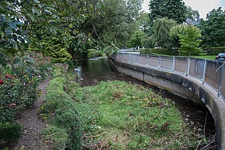
the Linnepe flows here through the place of the same name |
||
| Data | ||
| Water code | DE : 276186 | |
| location | Hochsauerlandkreis , North Rhine-Westphalia , Germany | |
| River system | Rhine | |
| Drain over | Röhr → Ruhr → Rhine → North Sea | |
| source | Northwest of Obersalwey 51 ° 15 ′ 35 " N , 8 ° 4 ′ 42" E |
|
| Source height | 523 m above sea level NHN | |
| muzzle | In Sundern in the Röhr coordinates: 51 ° 19 ′ 46 ″ N , 8 ° 0 ′ 20 ″ E 51 ° 19 ′ 46 ″ N , 8 ° 0 ′ 20 ″ E |
|
| Mouth height | 245 m above sea level NHN | |
| Height difference | 278 m | |
| Bottom slope | 19 ‰ | |
| length | 14.3 km | |
| Catchment area | 40.842 km² | |
The Linnepe is a 14.3 km long right tributary of the Röhr in the North Rhine-Westphalian Hochsauerlandkreis , Germany .
geography
The river has its source northwest of Obersalwey at an altitude of 523 m above sea level. NHN . From there it first flows in a northerly direction, passes Meinkenbracht in the west and flows through Linneper Hütte . There the river turns to the northwest. A little later the Linnepe flows through the village of the same name Linnepe . After flowing through Westenfeld , the Linnepe reaches Sundern , where it is 245 m above sea level. NHN flows into the tube. In the localities of Linnepe, Westenfeld and Sundern, the river has changed significantly and in some cases has been expanded like a canal.
On its 14.3 km long path, the Linnepe overcomes a difference in altitude of 278 m. This corresponds to an average bed slope of 19.4 ‰. It drains a 40.842 km² catchment area via Röhr , Ruhr and Rhine to the North Sea .
Tributaries
The most important tributary of the Linnepe is the 4.2 km long Rumke , which has the largest single catchment area with 8.549 km². The Mettmecke (4.8 km) and the Seilbach (4.7 km), which are almost the same length, are longer than the Rumke, but both have a much smaller catchment area.
In the following the tributaries of the Linnepe are listed in the order from the source to the mouth. The orographic location, the mouth position with indication of the stationing kilometer, the length, the size of the catchment area, the mouth height and the river code are given.
| Surname
|
location |
Stat. in km |
Length in km |
EZG in km² |
Mouth height in m above sea level NHN |
GKZ |
|---|---|---|---|---|---|---|
| Romecke | right | 11.9 | 2.2 | 439 | 276186 12 | |
| Seilbach | right | 8.5 | 4.7 | 5,539 | 355 | 276186 2 |
| Rumke | right | 5.7 | 4.2 | 8.549 | 300 | 276186 4 |
| NN | Left | 5.3 | 1.9 | 295 | 276186 52 | |
| Knew | right | 3.8 | 4.1 | 4,616 | 288 | 276186 6 |
| Mettmecke | right | 2.3 | 4.8 | 5.436 | 264 | 276186 8 |
| Schwartmecke | right | 1.7 | 0.7 | 259 | 276186 92 |
Notes on the table
- ↑ Water code number , in Germany the official river code number with a separator inserted after the prefix for better readability, which stands for the Linnepe receiving water shared by all .
nature and environment
Only in the localities of Linneper Hütte, Linnepe, Westenfeld and Sundern has Linnepe been greatly changed by man. There it flows partly like a channel, with the banks partly strongly fortified. There is no drinking water supply from the Linnepe.
For the management plan for the Water Framework Directive of the EU and the Linnepe commissioned by the Ministry for the Environment, Agriculture and Consumer Protection of North Rhine-Westphalia (MUNLV) was investigated. The Linnepe in its entirety was classified as natural despite building structures in the location. The general degradation and saprobism were rated as good. In animals and plants, these classifications were made, in macrozoobenthos , small organisms living on the bottom of the water, as good, in macrophytes , aquatic plants visible to the naked eye that live under and on the water surface, including chandelier algae , mosses and ferns and seed plants such as spawning herbs as good, and in phytobenthos , plants living on the bottom of the water, mainly algae, as moderate. The fish fauna was rated as good. With regard to the pollution of the Linnepe with nitrate , metals and other substances that may pollute the water, it was classified as good to very good. The chemical condition was rated as good. Because of the construction in the local areas, the ecological condition and the potential for improvement were only classified as moderate.
So far, kingfisher , dipper , gray wagtail and mallard have been identified as breeding birds on the Linnepe . Herons and black storks appear as food guests . The muskrat has been found on the river for years. The brown rat occurs in the local area of Sundern .
literature
- Ministry for the Environment, Agriculture and Consumer Protection of the State of North Rhine-Westphalia (MUNLV): Profiles of the planning units in the North Rhine-Westphalian parts of the Rhine, Weser, Ems and Maas (draft) - surface water and groundwater sub-catchment area Rhine / Ruhr MUNLV, Düsseldorf 2008, without ISBN.
