Wester
|
Wester (upper course: Wäster ) |
||
|
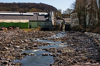
The wester below the Jungeblodt company during the renaturation process . View to the south, the passages under the plant can be clearly seen |
||
| Data | ||
| Water code | DE : 27624 | |
| location | Warstein , North Rhine-Westphalia , Germany | |
| River system | Rhine | |
| Drain over | Möhne → Ruhr → Rhine → North Sea | |
| origin | Confluence of Wideybach and Langer Bach south of Warstein 51 ° 25 ′ 35 ″ N , 8 ° 20 ′ 57 ″ E |
|
| Source height | 340 m above sea level NHN | |
| muzzle | At Belecke in the Möhne coordinates: 51 ° 29 ′ 20 ″ N , 8 ° 19 ′ 59 ″ E 51 ° 29 ′ 20 ″ N , 8 ° 19 ′ 59 ″ E |
|
| Mouth height | 252 m above sea level NHN | |
| Height difference | 88 m | |
| Bottom slope | 6.2 ‰ | |
| length | 14.3 km | |
| Catchment area | 54.496 km² | |
| Medium-sized cities | Warstein | |
The Wester ( called Wäster in the upper reaches ) is a left or southern, 8 km long tributary of the Möhne in North Rhine-Westphalia , Germany .
The name of the waterway appears in documents in 1471 as "Westerbroke" - Wester-Bruch (documents, Meschede Monastery, No. 363).
course

It arises in the Arnsberger Wald nature park around 2 km south of the center of Warstein at 343 m above sea level. NHN through the confluence of the Langen Bach coming from the southeast and the Wideybach coming from the southwest . From there it flows as a desert towards the north through Warstein and reaches as Wester Belecke , where it flows into the Möhne at an altitude of 252 m .
particularities
The Wester cuts through the two Warstein mass limestone ranges . Depending on the groundwater level in the karst aquifer , the upper reaches of the Wester can therefore completely disappear underground and the stream bed can fall dry. In the further course the Wester is fed by numerous karst springs, some of which are used as drinking water sources. In addition to the contained springs, there are numerous tributaries from the underground in the stream bed itself. The incoming karst groundwater is always well above 5 ° C, the water from the Bullerteich spring is even around 15 ° C warm. Due to this strong inflow of relatively warm karst groundwater from deeper layers, the Wester in the area of the city of Warstein has never frozen over.
This peculiarity is already mentioned by the early modern historian Hermann Hamelmann (1526–1595) in his book Simplex et brevis Delineatio Urbium et Oppidorum Westfaliae : “Wastena, Wasten: A town near the Ruhr, it has the peculiarity that water is found there which is cold in summer and warm in winter. "
The always flowing water meant a great locational advantage in the early industry, as the hydropower was available all year round and there was no failure due to frost in winter. Numerous mills and hammer mills have used every meter of the slope. In the area of the town of Warstein, the topographic map from 1837 shows two mills, a paper mill, a sawmill and a copper hammer on a course of 700 m of the river. The difference in altitude on this 700 m is only about 10 m. When the Warsteiner Eisenhütte was licensed in 1739, it could no longer rely on the water power of the Wester in this area, it was dependent on the small right-hand tributary of the Treise.
The course of the river and the floodplain south of Belecke have been designated as the Wästertal nature reserve.
Tributaries
The most important tributary of the Wester is the 5.0 km long Schorenbach , which, with its 20.804 km² catchment area, accounts for 38% of the Wester.
| Surname |
Stat. in km
|
location | Length in km |
EZG in km² |
Mouth height in m above sea level NHN |
GKZ |
|---|---|---|---|---|---|---|
| Sneeze | 11,251 | right | 1.0 | 27624 12 | ||
| Clay sieves | 10.378 | right | 1.5 | 27624 14 | ||
| NN | 9,656 | right | 2.3 | 27624 16 | ||
| NN | 9.048 | right | 1.4 | 27624 18 | ||
| Long stream | 8.172 | right | 4.2 | 5.042 | 27624 2 | |
| Range | 6.005 | right | 5.1 | 7.159 | 27624 4 | |
| Dorpke | 4.043 | right | 2.1 | 27624 52 | ||
| Schorenbach | 3.278 | Left | 5.0 | 20.804 | 271 | 27624 6 |
| Stockmecke | 2.702 | right | 1.5 | 265 | 27624 72 | |
| Hamecke | 1,783 | Left | 2.0 | 0.965 | 260 | 27624 8 |
| Syllable | 0.671 | Left | 2.5 | 254 | 27624 92 |
Individual evidence
- ↑ a b German basic map 1: 5000
- ↑ a b Topographical Information Management, Cologne District Government, Department GEObasis NRW ( Notes )
- ↑ Water directory of the State Office for Nature, Environment and Consumer Protection NRW 2010 (XLS; 4.67 MB) ( Notes )

