
Warstein
| coat of arms | Germany map | |
|---|---|---|

|
Coordinates: 51 ° 27 ' N , 8 ° 21' E |
|
| Basic data | ||
| State : | North Rhine-Westphalia | |
| Administrative region : | Arnsberg | |
| Circle : | Soest | |
| Height : | 310 m above sea level NHN | |
| Area : | 158.03 km 2 | |
| Residents: | 24,643 (Dec. 31, 2019) | |
| Population density : | 156 inhabitants per km 2 | |
| Postal code : | 59581 | |
| Primaries : | 02902, 02925 | |
| License plate : | SO, LP | |
| Community key : | 05 9 74 044 | |
| LOCODE : | DE WAN | |
| City structure: | 9 districts | |
City administration address : |
Dieplohstrasse 1 59581 Warstein |
|
| Website : | ||
| Mayor : | Thomas Schöne ( CDU ) | |
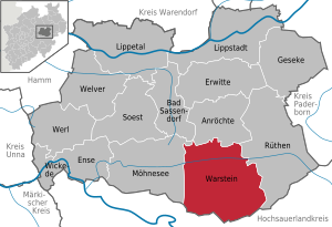
| Location of the city of Warstein in the Soest district | ||
  |
||

Warstein ( ) is a medium- town in the Soest district in North Rhine-Westphalia (Germany).
Around 25,000 people live in Warstein, which covers an area of 158.03 km² .
geography
Geographical location

Warstein is located in the southern part of the Soest district in the Arnsberger Wald nature park on the Wäster . It is located on the northern edge of the Sauerland to the hairline adjoining it to the north , behind which the Westphalian Bay lies.
The urban area of Warstein is divided into the forest-covered south (Warsteiner Wald) and the unwooded north ( Haarstrang ) . The Möhne river forms the boundary between the two landscape forms . The Haarstrang forms the border between the natural spatial unit 335 North Sauerland Oberland in the south and the unit 542 Hellwegbörden north of the Haarstrang .
The highest point of the urban area is about 4 km (as the crow flies ) south of the Warsteiner outskirts a few meters north of the highest point of the Plackweghöhe ( 581.5 m above sea level ) and the Arnsberger Wald nature park at 581.3 m above the Lörmecke in the forest Tower . The lowest point of the city is 216.5 m above sea level in the Beiwindetal in the north of the district of Waldhausen .
A special feature of the Beiwindetal is that during the Saale Ice Age, glacier meltwater, which was dammed up by the inland ice in the north, flowed over the Haarstrang into the Merpketal (tributary of the Möhne between Niederbergheim and Völlinghausen). In the area of the old brickworks of Niederbergheim, Nordic debris was found which crossed the hair with the meltwater. The approximate maximum ice level of the inland ice can be seen from the Schledden on the north side of the Haar. These all run, from a height of around 250 m and lower, towards the northeast, as the glacier was pushed against the Haar from the northeast and the valleys were deepened as a result.
Expansion of the urban area
The northernmost point of Warstein is between Uelde and Altenmellrich, the easternmost about 2 kilometers south of the Hohlen Stein . The southernmost point of the city is just 0.7 km southwest of the Stimmstamm pass , the westernmost of Warstein and at the same time southernmost of the municipality of Möhnesee 1.7 km northeast of the Lattenberg. The west-east extension of Warstein is about 14.5 km and the north-south extension about 14.9 km.
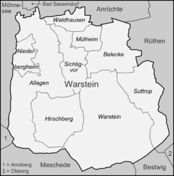
City structure
Warstein is divided into the nine districts Allagen , Belecke , Hirschberg , Mülheim , Niederbergheim , Sichtigvor , Suttrop , Waldhausen and Warstein (center).
Neighboring communities
Warstein's neighboring communities and cities are - listed clockwise starting in the north - Anröchte , Rüthen , Bestwig , Meschede , Arnsberg , Möhnesee and Bad Sassendorf .
climate
|
Average temperatures and precipitation values (1961–1990)
|
|||||||||||||||||||||||||||||||||||||||||||||||||||||||||||||||||||||||||||||||||||||||||||||||||||||||||||||||||||||||||||||||||||||||||||||||||||||||||||||||||||||
The annual mean temperature for the years 1961 to 1990 in the area of the city of Warstein was between +8.4 ° C on the lower ridges of the northern Haar and +6.4 ° C at the highest point of Warstein. The lowest absolute temperatures are measured due to the more frequent inversion weather conditions in the valley locations. The absolute maximum values are also reached in the valleys due to the low altitude. The coldest month is January with a mean temperature between −1.3 ° C on the highest mountain and +0.7 ° C immediately east of the nearwind valley (north of Waldhausen). The hottest month is July, where the mean is between +14.3 and +16.4 ° C.
The annual mean temperature for the years 1981–2010 changed by +0.7 K compared to the mean for the years 1961–1990. In a comparison of the individual months, July had the greatest warming at +1.1 K and October at +0.1 K experience the slightest warming.
Precipitation is highly dependent on location and season. On average between 1961 and 1990, the measuring stations of the German Weather Service (DWD) in Hirschberg fell 1087.5, in Warstein 1021.3 and in Belecke 903.4 millimeters of precipitation. The driest region of the city of Warstein is the Möhnetal immediately east of the center of Beleck with approx. 890 millimeters. The largest mean annual precipitation falls at the highest point of Warstein with around 1210 millimeters of precipitation.
These differences in precipitation arise from the topography sloping to the north and the associated leeward and Föhne effects. The seasonal differences are greatest in winter as the precipitation often comes from the southwest. In the winter months, about 30% more precipitation falls at the measuring station in Warstein than at the measuring station in Belecke. In summer, on the other hand, it is only around 6% more in Warstein, as most of the rain falls to the ground in the form of thunderstorms and showers and these are distributed quite evenly. Between the measuring stations in Warstein and Hirschberg there is only a minimal difference in the amount of precipitation between October and April. From May to September, around 12% more precipitation falls in Hirschberg than in Warstein. This is probably due to the forest areas surrounding the Hirschberg and the resulting greater water evaporation. This promotes the development of showers and thunderstorms or intensifies existing showers.
The annual mean precipitation for the years 1981–2010 changed compared to the mean for the years 1961–1990 by + 8%. In a comparison of the individual months, the range of changes ranged between −8% in January and + 28% in September.
history
prehistory


The oldest traces of human life in Warstein have been found in the Bilstein caves. The stone tools that were unearthed there during the excavation and development work in 1887 are, according to the latest research, dated to the Mesolithic . In addition, in the so-called culture cave 1 of the Bilstein caves finds from the bell beaker culture (a handle-tongue dagger made of copper ), a cylinder neck vessel from the Urnfield Age and numerous relics from the pre-Roman Iron Age (ceramic shards, jewelry, spindle whorls , human skull remains) were recovered.
middle Ages
The first documentary mention of Warstein has been wrongly moved to the year 1072 for years. This document - the founding document of the Grafschaft monastery in the Sauerland - has been recognized as a forgery for 80 years. A supplement was added to this forged document around the year 1200; and only in this late addendum does the place name Warstein appear (as "Warsten"). Thus Warstein was first mentioned in a document after 1200. The first documentary mention is related to disputes over the tithe zu Warstein, which can be classified in the larger dispute between the Counts of Arnsberg and the Archbishops of Cologne .
At that time, Warstein did not mean the area of today's old town of Warstein. Before the fortified city was founded on the Stadtberg, a settlement on the western slope of the Wester valley bore the name Warstein, today's Altenwarstein area. The first documented church in the Warsteiner area was also located there. Its foundations were uncovered in the 1950s in an excavation that was hardly ever professionally supervised. During field inspections in recent years, in addition to stone age litter finds, a few late medieval ceramic remains (12th to 14th centuries) and numerous slag remains have been found, which indicates iron processing already in the suburban settlement of Altenwarstein. This settlement was only a few hundred meters away from iron ore deposits that were still being exploited in the David mine until 1949.
The usual view that Warstein received city rights from Siegfried von Westerburg in 1276 has certainly been refuted. The exact date of the granting of city rights is not known. There is much to suggest that Warstein received city rights at the same time as the neighboring town of Belecke in 1296. Only after 1307 - under the Archbishop of Cologne Heinrich von Virneburg , Siegfried's second successor - was the Stadtberg built on.
Economic basics

Recently it has been discussed whether the mining industry background played a role in the founding of cities in the northern Sauerland in the late Middle Ages and, if so, how high this motivation should be assessed. The foundation of the city of Eversberg (1242) with its own coin is striking . Field archaeological results suggest that the Eversberger Münze processed its own raw materials, copper and silver , obtained on site. In this context, it is noticeable that all three cities founded by Siegfried von Westerburg in the Arnsberg Forest, Belecke, Kallenhardt and Warstein, are very close to ore deposits . In the Belecker area lead ore deposits occur (Külbe, Lanfer), in the Kallenhardt area lead and iron ore , in the Warsteiner area mainly iron ore (but also copper and lead ores). In 1364 Johann von Hückelheim was enfeoffed with a blacksmith's work . It is likely to have been the first documented ironworks in the Warstein area. Everything speaks for the fact that this first Warsteiner ironworks was at the foot of the Oberhagens . The Warsteiner Stadtberg is located on the opposite side of the valley and virtually guards the site of the former ironworks and mining for the very rich ores of the Oberhagen. This particular situation can still be clearly seen on a map from 1630.
In the Middle Ages, Warstein was a member of the Hanseatic League , which gave the city a certain level of prosperity. The former main industries were due to large forest areas Forestry , also the iron mining and processing, as well as agriculture . The coal and steel industry in particular experienced a considerable boom from the first third of the 18th century. In 1739 Matthias Gerhard von Hoesch founded an ironworks based on the local iron ore deposits on the border with the (then) neighboring municipality of Suttrop. The further processing was carried out by hammer mills and a home-made finished goods production. Following on from these traditions, Warstein and neighboring communities such as Belecke and Suttrop became a focus of early industrialists in Westphalia in the first half of the 19th century.
Modern times
At the end of the 18th century, the great political events began to broadcast on Warstein. Probably in connection with the French Revolution, there was considerable unrest among the citizens from 1789. In the so-called Warsteiner Patriot War, the so-called princes as a party of the leading citizens and the patriots faced each other. It was not until 1794 that the princes prevailed again. However, in view of the dire financial situation in the meantime, this group was also forced to undertake reforms.
Large parts of the city were destroyed by fire on December 31, 1802. As a result, the core of the city was relocated from the previously populated city hill to the river Wäster .
In 1802 the Landgrave of Hessen-Darmstadt occupied the Duchy of Westphalia and with it the city of Warstein. In 1816, after the Congress of Vienna, the area fell to Prussia.
As early as the 1830s, puddling plants and processing plants with considerable numbers of employees (for example Bergenthal or the Warsteiner mine and smelting works ) were established. With the rise of the Ruhr area, this structure fell into crisis again just a few decades later. The consequences were plant closings, unemployment and high emigration figures. The crisis was overcome essentially by the abandonment of iron and steel production and the transition to the manufacture of specialized products (especially axles for wagons and railways).
The Warstein office has existed since 1844 . During the revolution of 1848/1849 there were again conflicts in the population in Warstein. During the German Empire, the labor movement made itself felt in Warstein much earlier and more strongly than in most other communities in the Sauerland.
Period of National Socialism and World War II

The psychiatric clinic, which was founded as Provincial Insane Asylum in 1902, later referred to as Provincial Hospitals (now LWL-Klinik Warstein ), was part of the regime's policy towards the disabled during the Nazi era. According to the law for the prevention of hereditary offspring of 1933, compulsory sterilizations were carried out to a considerable extent. Between 1940 and 1943, as part of the euthanasia policy, a total of 1575 patients were “transferred” to facilities such as the Hadamar killing center . In his euthanasia sermon, Bishop Clemens August Graf von Galen explicitly referred to the transports from Warstein. The pastor Lorenz Pieper , who had previously been convinced of National Socialism, wrote a protest against the killing in 1941 and was therefore released. A chapel on the clinic grounds today commemorates the victims.
From September 1944 the division staff of the V2 program was in Suttrop near Warstein. Shortly before the end of the war , in March 1945, columns of several hundred forced laborers passed through Warstein. The workers were emaciated and some of them begged the population. They were guarded by the Volkssturm and in the evenings were locked up in makeshift camps, including the rifle hall on the Herrenberg in Warstein, together with groups of forced laborers deployed in local companies. Shortly before March 20, 1945, SS-Obergruppenführer Kammler and his vehicles got caught in a traffic jam caused by the number of forced laborers retreating. In addition, while walking in a forest near Warstein, he came across an unguarded camp of forced laborers. Since the local authorities did not seem to be able to control the situation, Kammler ordered his subordinates to shoot a large number of forced laborers in order to restore order. On this order from Kammler, between March 21 and 23, 1945, 208 forced laborers were shot in the massacre in the Arnsberg Forest during three shootings in the Arnsberg Forest (including in Warstein and Suttrop), including women and children.
The US Army occupied from 5 to 8 April 1945, the present-day city of Warstein. There was light fighting with some of the dead.
Since the municipal reorganization
Warstein has existed in its current form since January 1, 1975, when the structure of North Rhine-Westphalia was completely changed as part of a regional reform ; because the Warstein office was merged with the surrounding towns and communities Allagen, Belecke, Hirschberg, Mülheim / Möhne, Sichtigvor, Suttrop and Waldhausen to form the new town of Warstein. In addition, Warstein from the Arnsberg district, which was largely incorporated into today's Hochsauerlandkreis , was assigned to the Soest district .
The legionnaire's disease outbreak in Warstein in 2013 was the most widespread occurrence of this disease in Germany to date.
Population development

|
|
Religions


General
Warstein originally belonged to the Archdiocese of Cologne . In 1821, with the bull of Pope Pius VII. De salute animarum , Warstein was added to the diocese and later the archbishopric of Paderborn . The Reformation could not prevail in Warstein. Today more than 2/3 of the population are Roman Catholic and belong to the Warstein pastoral association with the parishes of St. Petrus Warstein, St. Pankratius Warstein, St. Christophorus Hirschberg and St. Johannes Enth. Suttrop as well as the pastoral association Möhnetal . After the Congress of Vienna , which Warstein agreed to Prussia , Protestants settled in the course of industrialization . With the influx of refugees after the Second World War , more Protestant Christians came to Warstein. The church of the Evangelical Congregation, opposite the house Kupferhammer , was built between 1852 and 1857. About 20% of the population in Warstein belong to the Evangelical Church, almost 15% have another religion or no religion at all.
Jewish community

The traditional Jewish community of Warstein (first mention of Jews in Warstein 1664) went under during the Third Reich . Already in the 19th century the community had shrunk to three families when they moved away. The small half-timbered synagogue on Rangestrasse was devastated during the Reichspogromnacht , but not destroyed. In the following years it served as an agricultural barn, probably also as a cattle shed (although there are contradicting statements on this point). The synagogue was demolished in 1971. The Jewish families Cohn and Arensberg, who were still living in Warstein, emigrated to Argentina in 1939 ; Irmgard and Julius Gonsenhäuser and Berta Kaufmann did not succeed in emigrating. Julius Gonsenhäuser died in Buchenwald concentration camp . His urn was buried in the Jewish cemetery in Warstein.
There was no new beginning for a Jewish community in Warstein after the war, even if some Jewish people have moved here again. The emigrated families did not return. References to Jewish life in the city can still be found in the newly created street names Moritz-Kaufmann-Gasse (Moritz Kaufmann was head of the Warsteiner synagogue community), Synagogengasse (a connecting street between Rangestraße and the Salzbörnchen, which leads past the former synagogue site ) .
The Jewish cemetery has largely been preserved, although it must have evidently been relocated grave monuments. Since 2002 the Jewish cemetery has been entered in the list of monuments of the city of Warstein.
A hallway designation “Judenkirchhof” was sometimes associated with a Jewish burial place in local literature. But that is certainly wrong. The forest area "Judenkirchhof" is just below the Plackweghöhe , about 5 km south of the city. The name probably comes from the numerous hills that were found here and in many other places in the Arnsberg Forest . In the past, these mounds were often interpreted as burial mounds (for example in connection with the Varus Battle ). Archaeological investigations of other hills in the Arnsberg Forest have shown that they are not burial mounds. The exact background has not yet been clarified.
politics
Municipal council
In the elections to the municipal council on May 25, 2014, the following distribution of seats resulted:
| Party / group | Seats |
|---|---|
| CDU | 16 (+2) |
| SPD | 10 (+1) |
| BG | 5 (−5) |
| WAL / GJ | 3 (± 0) |
| FDP | 1 (± 0) |
| left | 1 (± 0) |
Results of the local elections from 1975
| year | CDU | SPD | Warsteiner List 1 | BG | FDP | The left. | Others |
|---|---|---|---|---|---|---|---|
| 1975 | 56.3 | 39.2 | - | - | - | - | 4.5 |
| 1979 | 57.3 | 42.7 | - | - | - | - | - |
| 1984 | 52.3 | 35.1 | 12.6 | - | - | - | - |
| 1989 | 47.0 | 39.9 | 7.5 | 5.6 | - | - | - |
| 1994 | 49.9 | 37.7 | 6.9 | 4.3 | 1.2 | - | - |
| 1999 | 41.4 | 36.2 | 7.4 | 15.1 | - | - | - |
| 2004 | 42.6 | 30.2 | 6.5 | 18.4 | 2.3 | - | - |
| 2009 | 37.2 | 22.1 | 8.4 | 25.5 | 3.6 | 3.1 | 0.1 |
| 2014 | 43.6 | 27.7 | 8.7 | 14.3 | 2.2 | 3.9 | - |
1 since 2009 as Warsteiner List / Green Youth
mayor
- 1946–1946 Karl Pieper, CDU
- 1946–1948 Hermann Risse, CDU
- 1948–1952 Josef Menke, SPD
- 1952–1967 Hermann Risse, CDU
- 1967–1969 Engelbert Kropff, CDU
- 1969–1974 Heinrich Linnenbrügger, CDU
- 1975–1989 Hermann Kroll-Schlueter , CDU
- 1989–1994 Georg Juraschka, SPD
- 1994–1997 Manfred Gödde, CDU
- 1997–1999 Clemens Werner, CDU
- 1999–2004 Georg Juraschka, SPD
- 2004–2015 Manfred Gödde, BG
- 2015– Thomas Schöne , CDU
badges and flags
The city of Warstein was granted the right to use a coat of arms in a certificate from the District President Arnsberg dated April 10, 1991 (previously also on August 13, 1975).
- Description of coat of arms
- Split by silver (white) and red, in front a continuous black cross, in the back nine silver (white) balls, 5: 4 arranged by stake.
- Meaning of the coat of arms
- The black cross on a white background stands for the Archdiocese of Cologne. The nine white dots on the back of the coat of arms symbolize the nine districts.
- Previously, the Warstein office had a black coat of arms on which a white city gate is depicted, in which St. Peter (patron of the diocese of Cologne) stands with a cross and a key.
- Banner:
- The city of Warstein was also granted the right to use a banner with a certificate from the District President Arnsberg dated April 10, 1991.
- Description of the banner
- From white to black to white in a ratio of 1: 3: 1, the city's heraldic shield is in the upper half of the central strip.
Town twinning
Warstein maintains city partnerships with the following cities:
- Saint-Pol-sur-Ternoise , France , since 1964
- Wurzen , Saxony , since October 3, 1990
- Hebden Royd , United Kingdom , since November 1995
- Pietrapaola , Italy , since September 2010
Culture and sights
theatre
Theater performances take place in the theater auditorium in the Belecke district.
Museums

The house Kupferhammer on the B 55 is a castle-like building that was created in several phases and which last served as a residence for the industrial family Bergenthal . Today it is home to the City Museum, the largest and most famous museum in Warstein. In addition to the upper-class living in the 18th and 19th centuries, which can be authentically reproduced here, there are some exhibition areas on the topics of iron processing, geology, a collection of hunting copper engravings by Johann Elias Ridinger and a winter garden with sculptures, including the Gothic Warsteiner Madonna has special value (a dehio star).
Further museums can be found in the districts: The Treasury Propstei Belecke is home to the city museum for sacred art and local history , a home parlor has been set up in the Dassel House in Allagen , a hunting room is located in Hirschberg and a chain forge museum is in Sichtigvor .

In the former youth hostel, directly at the exit of the Bilstein cave , there is a small information exhibition on the Bilstein cave (prehistoric and paleontological finds, medieval iron production in the Bilstein valley, dimensions of the Bilstein cave).
The LWL-Klinik Warstein with its own museum offers an insight into over 100 years of psychiatry history.
music
There are several music associations in Warstein, for example wind orchestras in Allagen and Sichtigvor , several choirs and marching bands throughout the city, hunting horn players in Warstein, Hirschberg and Suttrop, and a rock club in Suttrop. The former city music school, which has been run by a private provider since summer 2008, offers singing lessons for preschool children; But playing instruments and orchestral work are also taught here.
The music group Warstein-Project is dedicated to the respective regional Heimatlied in the Sauerland and wants to transmit, distribute and thus preserve almost forgotten, but also well-known and own Warsteiner Heimatlieder newly edited and free on the Internet as text and sheet music. In particular, songs by Heimat composers Karl Stoer and Carl Beutin, but also some of their own, represent the Warsteiner Lied collection to be built up, above all the Warsteiner Heimatlied (Karl Stoer, 1928) and Die Alte Bank (Carl Beutin, 1957). Downloads of the songs and historical source material and films complete the fund.
Buildings


In addition to the Kupferhammer house, the many churches in the city area should be mentioned here. The neo-Gothic Catholic St. Pankratius parish church and the market square in front of it form the center of the city center. Other buildings in the vicinity of the Pankratiuskirche from the 're-establishment phase' of Warstein - Progymnasium, town hall, district court - fell victim to the modernization of the 1960s and 1970s. In the early 14th century the old church was built on the Stadtberg. Its construction from around 1307 is related to the establishment and layout of the fortified town of Warstein. The church, located at the highest point of the city hill, was part of the city fortifications, its strong tower served as a defensive tower, in a sense as the keep of the fortifications. Only the sparse remains of the former city wall are preserved today. Due to various city fires in the early modern period, hardly any old building fabric has been preserved. The oldest building (after the old church) is the Zehnthof on the Stadtberg, an 'outpost' of the Grafschaft Monastery, where the tithe duties from the area had to be delivered. The oldest surviving farmhouse (Auf'm Bruch) dates from the 18th century. Classicist substance from the 19th century is sparse (main street, market square).
The old town of Beleckes and the upcoming one in Mülheim are also historically significant , but the appearance of the town centers in the other districts is also determined by half-timbered houses .
In addition, the Lörmecke tower should be mentioned, which in the Warsteiner Forest next to the highest point of Warstein or near the highest point of the Arnsberger Wald nature park serves as a viewing point in the Hochsauerland .
Nature and landscape protection
The urban area is embedded in protected areas of importance to Europe. In the north is the bird sanctuary Hellwegbörde with z. Some of the internationally significant breeding populations of Montagu's Harrier, Hen Harrier and Corn Crake and of particular importance as a resting and migration area. The south is part of the Arnsberg Forest Nature Park , which u. a. lies in a density center of the black stork and has a particularly high habitat density of this species in the area around Warstein. Other parts of the urban area of Warstein are designated as landscape protection areas.
In Warstein, nine areas have been designated as nature reserves (NSG). Five of these have been designated both as a nature reserve and as a European protected area ( FFH area ). Four of the nature reserves have parts of the protected areas in other urban areas. These are the nature reserves Arnsberg Forest (3,920.4 ha, sub-area in the Möhnesee municipal area, FFH area), Lörmeckal (270 ha, sub-area in the Rüthen urban area, FFH area), Möhnetal (154.7 ha, sub-areas in the Möhnesee municipal area and in the urban area of Rüthen, FFH area), Hamorsbruch and spring brooks (307.12 ha, FFH area), Oberhagen (13.24 ha), Liethöhle and creek shrinkage of the laundry brook (24.97 ha), Drewer quarries (9.7 ha, sub-area in the city of Rüthen), Wästertal (36.65 ha) and Piusberg (8.44 ha).
In addition, there is an accumulation of near-natural stream valleys in Warsteiner Forests, which, together with their surroundings, are to be defined as nature reserves within the framework of landscape planning . The purpose of these specifications from the 2012 regional plan is to improve their function as a habitat for animals and plants.
Parks

The Bullerteich, which is fed by the spring of the same name, is located on the busy B 55 as a small recreational island next to the police station.
The Warstein wildlife park is located west of the city. In addition to the wildlife park with its native wild animals such as lynx, red deer, fallow deer and many more, you can visit the Bilstein cave, which is an important stalactite show cave in Germany.

Particularly noteworthy is the park-like area of the large psychiatric clinic on Stillenberg (Suttrop district). The clinics were laid out over a large area in 1907, and the areas between the individual departments were landscaped.
Sports

In Warstein there are many sports clubs in which different sports are offered, led by soccer (TuS 45 Warstein) and handball (VfS Warstein). The Warsteiner indoor pool was converted into an all-weather pool only a few years ago . Tennis courts can be found in almost every district.
A major attraction is through since 1986 annual Warsteiner International Montgolfiade of ballooning . Also, the riding sport has become popular through the brewery in Warstein. Every year the Warsteiner Champions Trophy takes place near the Montgolfiade site. Above all, it should offer young riders a chance to establish themselves in the professional business.
Regular events
On the weekend of the third Sunday in October, the traditional Warsteiner autumn fair takes place from Friday to Monday. The finale is the fireworks display on Monday.
The beleckers celebrate the anniversary of the last attack on the place in the course of the Soest feud with the storm day on the Wednesday before Pentecost . The Schnadezüge are tradition in almost every district and the rifle festivals that take place in almost every district.
Carnival is also very important. Carnival societies exist in many districts, for which Rose Monday with the colorful parades is always the highlight. Two Rose Monday parades take place in the city: one organized by the Warsteiner and Suttrop carnivalists together, the other in Belecke.
economy

The economic focus in Warstein is:
- Forestry: The southern part of the urban area of Warstein is almost completely covered by forest except for the populated areas of Warstein, Suttrop and Hirschberg.
- The Agriculture : By loess soil is the part north Möhne good for agriculture suitable. He belongs to the Soest Börde .
- the brewing : The Warsteiner Brewery is one of the largest breweries in Germany. There is also a small brewery in Suttrop
- the iron processing : including in the Siepmann plants
- the electrical -sized enterprises in this industry have in Belecke settled (for example, Infineon Technologies AG).
- the mining (lime open pit ): The high purity Warsteiner limestone takes place in cement works in a wide area to correct the raw material mixtures use.
Infrastructure
traffic
Street
Federal highways 55 and 516 run through the urban area of Warstein . By the B 55, the city is connected in the north via the junction Erwitte / Anröchte with the federal highway 44 and in the south via the junction Meschede with the federal highway 46 . A bypass of the inner city has been debated for decades, but without success. A bypass road (Emil-Siepmann-Straße) was completed in the Belecke district a few years ago.
Transportation
Warstein is connected to large parts of the Soest district by regional bus routes. Regular bus routes run (at least on weekdays) to Lippstadt, Soest and Meschede.
rail
The next train stations with passenger traffic are in Meschede , Soest and Lippstadt ; the Warsteiner train station is only used for freight traffic. The Warstein – Lippstadt rail link was opened in 1883 and is part of the WLE (Westfälische Landeseisenbahn) route network . Passenger traffic on this route was discontinued in 1975. From the Warstein train station, some of the Warsteiner limestone quarries and, since spring 2005, also the Warsteiner brewery are opened.
Airport
The airport Paderborn / Lippstadt is about 30 km away. There is a glider airfield in the Ruhr valley near Oeventrop .
media
The daily newspapers Soester Anzeiger as well as the Westfalenpost and the Westfälische Rundschau are available in Warstein . There are no longer any local editorial offices in Warstein for the latter two sheets. The WOLL magazine also appears quarterly with regional topics.
The district of Soest is the broadcasting area of the local radio station Hellweg Radio, which is part of the framework program of Radio NRW and is based in Soest.
Public facilities
jurisdiction
The city is the seat of the Warstein District Court responsible for Warstein and Rüthen .
education
Elementary schools
- Johannes Primary School Allagen
- Westerberg Belecke primary school
- Christophorusschule Hirschberg (closed at the end of the 2011/12 school year)
- St. Margaretha School Visually
- Suttrop primary school
- Lioba school in Gutenberg Warstein (closed at the end of the 2011/12 school year)
- Lioba School Warstein
secondary schools
- Municipal secondary school in Warstein, Belecke district (closed at the end of the 2018/19 school year)
secondary school
- Municipal secondary school in Warstein, Belecke district (closed at the end of the 2018/19 school year)
Secondary school
- Municipal secondary school in Warstein district Belecke
high school
- High school in the city of Warstein
special school
- Grimmeschule, special school with a special focus on learning
Adult education
The catchment area of the Möhne-Lippe adult education center extends to the Soest district.
Healthcare
Hospitals
There are two hospitals in Warstein : the Maria Hilf Warstein hospital as a primary care hospital and the Warstein psychiatric LWL clinic .
Ambulance service
There is also an ambulance station in Warstein, operated by the Soest district, with an NEF , an RTW and a KTW in 24-hour service and another RTW in 12-hour service. The guard includes a branch with an ambulance on 24h duty in the Warsteiner district of Belecke.
Volunteer firefighter
In the districts there are fire fighting teams and fire fighting groups (at least 9 emergency services), depending on their size, these also each have a leader or fire fighting team leader and a deputy.
In order to be able to act quickly and effectively in an emergency, the units of the City of Warstein are organized as follows:
- Fire fighting train 1: Warstein district
- Fire fighting train 2: Belecke district
- Fire fighting train 3: districts of Hirschberg and Suttrop
- Fire fighting train 4: Allagen, Mülheim, Sichtigvor and Waldhausen districts
- Fire fighting train 5: Individual vehicles from the city of Warstein also help other cities in the event of major damage incidents, they then form the "regional aid"
If fire brigade members from other cities and communities work in Warstein and are with another local fire brigade, they can, under certain circumstances, go on missions. Within the city of Warstein, this has been practiced for a long time, i. H. there are volunteer firefighters from other parts of the town who work in Warstein or Belecke and also go on missions there during the day.
Telephone prefixes
The following codes apply:
- 02902 for Belecke, Hirschberg, Suttrop and Warstein
- 02925 for Allagen, Mülheim, Niederbergheim, Sichtigvor and Waldhausen
Personalities
sons and daughters of the town
- Benito Bause (born 1991), actor
- Hans-Josef Becker (* 1948), born in the Belecke district , Archbishop of Paderborn
- Wilhelm Bergenthal (1805–1893), founder of the mining industry in the Westphalian region.
- Dominic Boeer (* 1978), born in Warstein, actor
- Albert Cramer (1943–2012), entrepreneur. The Warsteiner Brewery is also part of the Haus Cramer Group.
- Josef Ferber (1874–1951), born in the Allagen district, architect.
- Josef Freisen (1853–1932), Catholic theologian, university professor and canon lawyer.
- Frieda Grafe (1934–2002), born in the Mülheim district, film critic, film essayist and translator.
- Rainer Hannig (* 1952), Egyptologist, teaches at the Philipps University in Marburg, founder of Egyptology in China and author of the Hannig Lexica.
- Friedhelm Hillebrand (* 1940) born in Sichtigvor, today Warstein, engineer and pioneer of mobile communications (co-inventor of the short message service SMS)
- Wilhelm Hoff (1851–1940), born in the Hirschberg district, organizer of the Prussian railways and minister for public works.
- Robert Jütte (* 1954), medical historian
- Jost Kalckhoven (* around 1620–1669 / 1670), publisher in Cologne.
- Sven Köhler (* 1996), soccer player.
- Erinna König (* 1947), painter
- Hermann Kroll-Schlüter (* 1939), born in the Belecke district, mayor of Warstein, member of the Bundestag and State Secretary in Saxony.
- Fabian Navarro (* 1990), poetry slammer
- Willi Ostermann (1920–2013), soccer player (Bonner FV and Meidericher SV)
- Josef Raulf (1933–1993), local politician
- Thomas Schöne (* 1967), lawyer and mayor of Warstein; born in the Maria Hilf Hospital
- Theodor Schroeder (1829–1890), born in the Mülheim district , lawyer, member of the Reichstag and politician of the Center Party.
- Heinrich Schulte (1804-1891), born in the Allagen district, Catholic priest, cathedral capitular and reign of the seminary in Paderborn.
- Karl-Werner Schulte (* 1946), university professor, founder of German research in the field of real estate science.
- Ferdi Schüth (* 1960), born in the Allagen district, chemist
- Christian Simmert (* 1972), politician (Bündnis 90 / Die Grünen) and former member of the Bundestag.
- Jan-Lennard Struff (* 1990), tennis player
- Elmar Witt (* 1960), conductor, horn player and music teacher
- Hans Weller (1947–2016), born in the Oberbergheim district, teacher, founding managing director of Hellweg Radio, Ministerialrat in the Ministry of Education in Saxony
Personalities with a connection to the city
- Johann Theodor Möller (1705–1763), copper industrialist and owner of Haus Kupferhammer
- Johann Karl Heide (1897–1974), resumed his career as a politician in the Warsteiner SPD district office after the Second World War
- Hans Sommer (1909–2000), sculptor
- Dagmar Hanses (* 1975), politician and member of the Bundestag (Bündnis 90 / Die Grünen)
literature
- Wolfgang Heppekausen, Christian Clewing: Warstein: Pictures of a city in the Sauerland . Self-published, Warstein 2001, ISBN 3-00-008520-3 .
- Franz Gerte on behalf of the Möhne-Lippe Adult Education Center: How was that? Belecke 1923-1948 . Self-published, Belecke 2001.
- Fritz Bamberg: The new city of Warstein in old views . European Library, Zaltbommel 1986, ISBN 90-288-3363-3 .
- Josef Bender: History of the city of Warstein . Stein, Werl 1973, ISBN 3-920980-03-4 ( original edition ).
- Günther Sandgathe: The city of Warstein in the Thirty Years War . Self-published, Warstein 1971.
- Peter Meiburg (ed.): Geology and mineralogy of the Warsteiner area . Aufschluss special volume 29, VFMG, Heidelberg 1979 ( PDF; 38 MB ).
Web links
- Web presence of the city of Warstein
- Warstein in the Westphalia Culture Atlas
Individual evidence
- ↑ Population of the municipalities of North Rhine-Westphalia on December 31, 2019 - update of the population based on the census of May 9, 2011. State Office for Information and Technology North Rhine-Westphalia (IT.NRW), accessed on June 17, 2020 . ( Help on this )
- ↑ The Treise Chapel, memorial for the victims of euthanasia , brief description of the clinic during the Nazi era
- ↑ Franz-Werner Kersting : The Nazi euthanasia as a challenge to the culture of peace, p. 6 ( online version PDF; 50 kB).
- ↑ Westfälische Rundschau from January 29, 1959.
- ^ Federal Statistical Office (ed.): Historical municipality directory for the Federal Republic of Germany. Name, border and key number changes in municipalities, counties and administrative districts from May 27, 1970 to December 31, 1982 . W. Kohlhammer, Stuttgart / Mainz 1983, ISBN 3-17-003263-1 , p. 331 .
- ↑ it.nrw.de ( Memento of the original from June 13, 2012 in the Internet Archive ) Info: The archive link was inserted automatically and has not yet been checked. Please check the original and archive link according to the instructions and then remove this notice.
- ↑ currently according to wdr.de , last viewed on August 31, 2009, 1:45 p.m. CEST
- ^ Main statute of the city of Warstein . March 6, 2018, p. 2 ( warstein.de [PDF; 1.1 MB ; accessed on February 9, 2020]).
- ↑ Homepage of the museum
- ↑ Eckart Roloff , Karin Henke-Wendt: Modern beginning - and then the many dark sides (Psychiatry Museum of the LWL Clinic in Warstein). In: Visit your doctor or pharmacist. A tour through Germany's museums for medicine and pharmacy. Volume 1, Northern Germany. S. Hirzel Verlag, Stuttgart 2015, ISBN 978-3-7776-2510-2 , pp. 163-165.
- ^ Gedeon et al .: Atlas of German breeding bird species . Dachverband Deutscher Avifaunisten, 2015, ISBN 3-9815543-3-7 , p. 180-181 .
- ↑ http://www.naturschutzinformationen-nrw.de/bk/de/karten/bk Biotopkataster NRW
- ↑ Textual definition of the regional plan for SO / HSK
- ↑ Explanatory card 12 on the regional plan for SO / HSK
- ↑ http://www.zu-den-zuegen.de/seiten/wle2/bier/501.htm
- ^ Homepage of the Maria Hilf Warstein hospital