
Hirschberg (Warstein)
|
Hirschberg
City of Warstein
|
|
|---|---|
.png) |
|
| Height : | 432 (300-464.7) m |
| Area : | 18.03 km² |
| Residents : | 1770 (Jan. 1, 2017) |
| Population density : | 98 inhabitants / km² |
| Incorporation : | 1st January 1975 |
| Postal code : | 59581 |
| Area code : | 02902 |
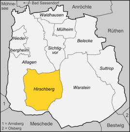  Location of the district in Warstein
|
|
 Aerial photograph Hirschberg (2014)
|
|
Hirschberg is a district of the Sauerland town of Warstein in the Soest district . As of January 1, 2017, it had 1770 inhabitants.
geography
Neighboring places
Hirschberg's direct neighbors, which are also part of the town of Warstein and the district of Soest, are Allagen , Sichtigvor (both northern locations) and Warstein (eastern locations). Meschede, which belongs to the Hochsauerland district, is located south of Hirschberg .
climate
Hirschberg is assigned to the moderate climatic zone. In Hirschberg, an average of over 1000 mm of rain falls annually, in particular above-average amounts of rain can be expected in the summer months of June and July and in the winter month of December. Due to the Hirschberg's altitude of 432 meters, moderate to heavy snowfalls are to be expected regularly in winter .
|
Average precipitation values (1961–1990)
|
|||||||||||||||||||||||||||||||||||||||||||||||||||||||||||||||||||||||
history
.jpg)
The first definitely tangible settlement in the vicinity of Hirschberg is the settlement and later the deserted monastery of Odacker , approx. 1.5 km northeast of today's Hirschberg. This is mentioned in a Cologne note from the late 12th century as the border point between the Osterwald (the eastern part of today's Arnsberg Forest Nature Park ) claimed by Cologne against the County of Arnsberg and the western part of the forest, which Arnsberg undisputedly belongs to. After the construction of the city of Hirschberg, a small nunnery settled in the Odacker area .
Junggrave Wilhelm von Arnsberg granted Hirschberg city rights on July 26, 1308 . This granting of city rights was opposed by the Archbishop of Cologne, who as Duke of Westphalia had the sole right of fortification. In a letter, which can no longer be dated with certainty, the Archbishop of Cologne, Heinrich von Virneburg , urged his cities Soest , Brilon , Rüthen , Marsberg , Geseke , Warstein to oppose the fortifications that had begun in Hirschberg and Bergheim (an Arnsberg misfoundation, to be found in the area of today's Niederbergheim ) proceed. Obviously this intervention worked. A fortified city was not built on the Hirschberger Stadtberg. Only the last of the Arnsberg counts - Gottfried IV. - succeeded in fortifying Hirschberg. He negotiated a contract with the Archbishop of Cologne, Walram von Jülich , which, on the one hand, allowed him to fortify Hirschberg, but on the other hand, gave the city of Hirschberg a fiefdom to the Archbishop of Cologne .
In this late phase of the Arnsberg county, Count Gottfried IV paid attention to the economic and infrastructural importance. The new town of Hirschberg could no longer exude strategic importance and military strength. That was the only reason why Walram von Jülich approved the fortification. It was not until 1340 that the city fortifications were expanded with a new city castle and a city wall with ramparts and moats. A new castle chapel was also consecrated. In 1350 the St. Christophorus Church was completed. In 1368 the Arnsberg ruler sold the entire county to the Archdiocese of Cologne . In the next few decades the town castle was expanded into a hunting lodge . In 1403 or 1404 Hirschberg joined the Hanseatic League . In 1442 a city seal was approved. Hirschberg fought alongside Cologne between 1444 and 1449 in the Soest feud and was looted twice during this time. In 1583 the Odacker Monastery was burned down for the first time. In 1584 Ernst von Bayern took over the rule. He stationed the highest Westphalian hunting and forestry office in Hirschberg. This place was not spared from a city fire, in 1597 large parts of the city burned down. In the 30 Years War the Odacker Monastery was completely destroyed again. In 1633 the town center was also destroyed; neither the hunting lodge nor the church survived the year. In 1648 the reconstruction of the monastery began. A few years later the hunting lodge and a chapel were also rebuilt. In 1778 there was a second city fire; In 1788 the place was again largely in flames.
From 1802 Hirschberg belonged to the Landgraviate of Hessen-Darmstadt . Two years later the monastery was abandoned; the property was sold to residents of Hirschberg. Another three years later, in 1807, Hirschberg lost its town charter again. At that time it was subordinated to the “Justice Office Belecke ”. In 1810 and 1811 the castle was torn down except for the north wing. From 1816 Hirschberg belonged to the Prussian province of Westphalia , the administrative district of Arnsberg and the district of Soest (from 1823 the district of Arnsberg ). Until the end of 1974 it was an independent municipality in the Arnsberg district. On January 1, 1975, Hirschberg became a district of Warstein and came back to the Soest district after 159 years.

Witch hunts in Hirschberg
In the small town of Hirschberg three phases of witch hunts took place: in 1595 several men and women were executed for witchcraft. From 1616 to 1617, 13 people were charged as witches. In 1616 the notorious witch judge Heinrich von Schultheiss directed the witch trials in the little town of Hirschberg. In 1617 Steffen von Niederbergheim fell victim to the witch hunt. From 1628 to 1629 12 people were killed in witch trials. Pastor Michael Stappert worked here during this time . A monument in the town of Rüthen commemorates his work .
These processes are described in the work Hochnötige Unterthanige Wemütige Klage Der Pious Invalid (1676) by Hermann Löher . This includes Michael Stappert's book on the witch trials.
In 1986 a memorial cross for the tortured women and men of the witch persecution with text panels on the witch trials was erected at the former execution site on the street Christoffelsberg in the "Eskelle", a forest on the outskirts.
Population development
From the end of the 19th century to the end of the 20th century, the population of Hirschberg increased continuously. In the post-war decades, the number of inhabitants in Hirschberg increased more strongly and in 1990 exceeded the mark of 2000 inhabitants. The population has been decreasing steadily since the beginning of the 21st century and has been 1702 since 2015.
|
|

Attractions

The place, which is characterized by half-timbered houses (about 30 of which have house inscriptions ), has won several awards in the competition “ Our village should be more beautiful ”.
- Christophoruskirche : The choir and the first vaulted yoke date from the 14th century. The south portal was built in 1708. After an almost complete demolition, a larger church with a tower in the south was consecrated in 1956. The tabernacle altar dates from the 18th century.
- Parsonage: The outer shape of a parsonage with living and agricultural parts has been preserved to this day. Large Deelentor (Querdeele) with Latin inscription.
- Bilsteinhöhle : The Bilsteinhöhle with the neighboring wildlife park is located between Hirschberg and Warstein.
- Memorial cross for victims of the witch hunts in the Eskelle, erected in 1986 on the former execution site
- Marstall, the horse stable of the former Hirscherger Castle
- Coal kiln area with foam kiln, charcoal burner hut and information board on the subject of "Köhler handicraft in the Sauerland"
Personalities
- Wilhelm Hoff (1851–1940), organizer of the Prussian railways and minister for public works
- Ernst Assmann (1903–1979), forest scientist
- Horst Langer (* 1939), table tennis player
Web links
- Place website
- Brief introduction on the website of the city of Warstein
- Information on the anniversary - 700 years of the city of Hirschberg (1308–2008)
- Website of the SGV-Hirschberg with extensive information on the history of the charcoal trade in Hirschberg
Individual evidence
- ↑ City of Warstein: Numbers, data, facts ( Memento of the original from May 19, 2015 in the Internet Archive ) Info: The archive link has been inserted automatically and has not yet been checked. Please check the original and archive link according to the instructions and then remove this notice. , accessed January 4, 2017
- ^ Federal Statistical Office (ed.): Historical municipality directory for the Federal Republic of Germany. Name, border and key number changes in municipalities, counties and administrative districts from May 27, 1970 to December 31, 1982 . W. Kohlhammer, Stuttgart / Mainz 1983, ISBN 3-17-003263-1 , p. 331 .
- ^ Rainer Decker: The witch hunts in the Duchy of Westphalia. Research status, sources and objectives . In: Landschaftsverband Westfalen-Lippe (LWL): Westfälische Geschichte , p. 350 (PDF; 28.7 MB), accessed on April 28, 2016 online version.
- ^ Numbers, data, facts: City of Warstein. (No longer available online.) Archived from the original on May 19, 2015 ; accessed on June 14, 2017 . Info: The archive link was inserted automatically and has not yet been checked. Please check the original and archive link according to the instructions and then remove this notice.
- ↑ Hartmut Hegeler , Hexendenkmäler in Westfalen , Unna, 2012, pp. 49–54
- ↑ picture of the memorial
Allages | Licking | Hirschberg | Mülheim | Niederbergheim | Visually before | Suttrop | Waldhausen