Visually
|
Visually
City of Warstein
|
|
|---|---|
| Coordinates: 51 ° 29 ′ 28 ″ N , 8 ° 16 ′ 43 ″ E | |
| Height : | 240 (235-401) m |
| Area : | 10.1 km² |
| Residents : | 2037 (Oct. 1, 2018) |
| Population density : | 202 inhabitants / km² |
| Incorporation : | 1st January 1975 |
| Postal code : | 59581 |
| Area code : | 02925 |
|
Location of the district in Warstein
|
|
|
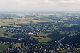
View of Sichtigvor and Mülheim
|
|
Sichtigvor is a district of the city of Warstein in the Soest district in North Rhine-Westphalia . As of October 1, 2018, it had 2,037 inhabitants.
geography
The place is located in the central Möhnetal south and north of the river on the border between the Arnsberg Forest and the Haarstrang .
history
The history and development of Sichtigvor is closely linked to that of the neighboring towns of Mülheim and Waldhausen .
Roman finds at the foot of the Loermund mountain led to a theory that this was the scene of the Varus Battle . However, since the finds near Kalkriese , this assumption has been disproved. It is more likely that the finds are only waste from Roman troops on their way to nearby camps in Kneblinghausen or in the Paderborn area .
From the 8th century is Wallburg on the Loermund known whose remains are still visible. This was one of a number of border posts that were set up in the Carolingian era on the border with the Saxon settlement area. This, expanded to include permanent buildings, later also served as a refuge for the residents of the central Möhne Valley.
Today's Sichtigvor was created in the 17th century as a servants' settlement for the Teutonic Order Mülheim an der siegden Four ( Low German for a low-lying driveway). The oldest documented mention of it comes from the year 1656. Since the settlement was on open ground, it was not subordinate to the sovereign (at that time the Archbishop of Cologne ), but to the Mülheim Commander . This status remained until the dissolution of the Teutonic Order in 1809 by Napoleon . Until then, Sichtigvor was dependent on Mülheim and subsequently became an independent political community. In terms of the church, Sichtigvor and Waldhausen belong to the Catholic parish of St. Margaretha Mülheim to this day and together with these places it forms the parish of Mülheim / Möhne.
After the Congress of Vienna , the former foundation of the order fell to the Kingdom of Prussia . At that time, the people of Sichtigvor lived mainly from agriculture and forestry . In the middle of the 19th century, the chain forging industry established itself, benefiting from the opening up of traffic in the Möhne Valley (today's B 516 ) . Besides some industrial forging there were also numerous home forges where the chains in paid work were produced. The last forge closed in 1955.
While previously the settlement area was directly on and south of the Möhne, in the second half of the 20th century building areas were designated in the floodplain and later also on the southern slope of the Haar. During this time, the population of Sichtigvors exceeded the Mülheims. In the course of administrative reform , which came into force on 1 January 1975 the hitherto independent Sichtigvor to the district of the newly formed city was Warstein and came with this from the old Arnsberg district to district Soest .
politics
The current mayor is Heike Kruse.
coat of arms
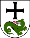
In silver (or white) under a free-floating black paw cross (as an indication of the close bond with the coming one) a two-legged, red-armored green dragon running to the left, looking around. This stands for the dragon slayer St. George, patron saint of the order and the community of Sichtigvor and as a symbol of the victory of good over evil with regard to the work of the knights of the order in their early days. At the same time, the dragon is the mascot of the SuS Sichtigvor soccer club.
Attractions
The townscape is dominated by an ensemble consisting of the St. Margaretha Church (built 1707–1714) and the former Teutonic Order Castle (built around 1682). Although the church is located on land the municipality Sichtigvor, however, is the parish church of the parish of Mülheim, in turn, is part of the Sichtigvor.
In 1845, residents of Sichtigvors built a way of the cross on the northern slope of the Loermund . The original wooden crosses were replaced by sandstone stations in 1865. In 1890 the Kreuzberg chapel was built on the Loermund .
In 1896 the Protestant St. Mark's Church was built on Möhnestrasse because, in the course of industrialization, more and more Protestant Christians settled in Sichtigvor, which had been almost exclusively Catholic until then.
In memory of the formerly dominant sector of the chain forging was founded in 1984 one from the home club chain forge museum built with a functioning forge, which can be visited by appointment.
literature
- Heinrich Schoppmeier, Kaspar Süggeler: The history of the communities Sichtigvor, Mülheim, Waldhausen. Balve 1968.
- Wilhelm Hecker, Helmut Fröhlich, Ulrich Peitz, Kirsten and Björn Besting: Visible stories. Warstein 2006.
Web links
Individual evidence
- ↑ City of Warstein: Numbers, data, facts ( Memento of the original from May 19, 2015 in the Internet Archive ) Info: The archive link has been inserted automatically and has not yet been checked. Please check the original and archive link according to the instructions and then remove this notice. , accessed November 9, 2018
- ^ Federal Statistical Office (ed.): Historical municipality directory for the Federal Republic of Germany. Name, border and key number changes in municipalities, counties and administrative districts from May 27, 1970 to December 31, 1982 . W. Kohlhammer, Stuttgart / Mainz 1983, ISBN 3-17-003263-1 , p. 331 .


