Hirschberger nakedness
| Hirschberger nakedness | |||
|---|---|---|---|
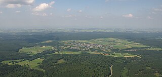
| Overview of the deforestation island Hirschberger Blöse. The Hirschberg town center is located in the center of the clearing island, but is not part of the natural area. | |||
| Systematics according to | Handbook of the natural spatial structure of Germany | ||
| Greater region 1st order | Low mountain range threshold | ||
| Greater region 2nd order | Rhenish Slate Mountains | ||
| Main unit group | 33 → Süderbergland |
||
| About main unit | 334 → North Sauerland Oberland |
||
| 4th order region (main unit) |
334.3 → Upper Arnsberg Forest |
||
| Natural space |
334.33 → Hirschberger nakedness |
||
| Geographical location | |||
| Coordinates | 51 ° 26 '16 " N , 8 ° 16' 29" E | ||
|
|||
| local community | Warstein | ||
| state | North Rhine-Westphalia | ||
| Country | Germany | ||
The Hirschberg pelt is a small-scale natural subunit with the order number 334.33 of the Upper Arnsberg Forest ("Buchwald") (334.3) within the North Sauerland Oberland (334). According to the handbook of the natural spatial structure of Germany, it includes the clearing island in the eastern Arnsberg Forest on three sides around 425 m above sea level. NN high mountain top Hirschberg, on which the Warsteiner village of Hirschberg is located.
The clearing is about 350 m above sea level. NN in a carbon - and shale - Ausraum of Heve -Quellgebietes from the Kulm facies . The Härtlingskopf Hirschberg, at the altitude of which the Counts of Arnsberg founded the town of the same name in the 14th century, is connected to the neighboring natural area of Kahlenbergsköpf (334.34) by a narrow saddle neck and is not itself part of the Hirschberg's nakedness. Other surrounding natural areas are the Heve-Möhne-Wald (334.31) in the north, the Breitenbrucher Wald (334.32) in the west and the Plackweghöhe (Plackwald) (334.5) in the south .
In the natural area in the meadow grounds, stunned gullies predominate. On the slopes of the Hirschberg you can find deep, not very alkaline and stony pebbles.

