Warsteiner hill country
| Warsteiner hill country | |||
|---|---|---|---|
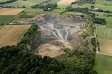
| View of the Warsteiner hill country with the quarry and the Hohe Lieth nature reserve. | |||
| Systematics according to | Handbook of the natural spatial structure of Germany | ||
| Greater region 1st order | Low mountain range threshold | ||
| Greater region 2nd order | Rhenish Slate Mountains | ||
| Main unit group | 33 → Süderbergland |
||
| About main unit | 334 → North Sauerland Oberland |
||
| Natural space |
334.4 → Warsteiner hill country |
||
| Geographical location | |||
| Coordinates | 51 ° 26 '56 " N , 8 ° 23' 43" E | ||
|
|||
| local community | Warstein , Ruethen | ||
| state | North Rhine-Westphalia | ||
| Country | Germany | ||
The Warsteiner Hügelland is a natural spatial unit with the order number 334.4 within the North Sauerland Oberland (334). According to the handbook of the natural spatial structure of Germany, it comprises the open limestone and clay slate hill country in the eastern Arnsberg Forest between the Warsteiner main town and the Rüthen district of Kallenhardt , both of which are completely in the natural area.

The hill country is largely unforested and geologically forms a separate, elongated oval clod complex , which is nestled in the surrounding higher slate mountains and is known as the Warsteiner Saddle . The rock in the underground, in contrast to the surrounding Grauwackeschiefern predominantly Massenkalken the Upper Middle Devonian and Flinzkalken and shales of the Upper Devonian .
The hill country is highly structured and can be divided into two areas. In the south, at the transition to the Plackwald (334.5), there is around 400 to 440 m above sea level. NN high mass limestone plateau , the limestone of which is discarded compared to the graywack slate there . As a result of erosion during the recent geological past, the plateau is roughly divided into smaller ridges and humps, which have height differences of 60 to 70 m and, in places, reveal open rock on the slopes. Thicker layers of rendzinen and alluvial loess are only present in hollows, otherwise the landscape looks remarkably bare. Several streams drain from the Plackweg heights into the limestone plateau, but they often disappear in underground karst caves . As a result, soil structures typical of karst areas have formed in the limestone plateau, such as sinkholes and limestone cave systems, such as the Liethöhle in the Liethöhle nature reserve and stream shrinkage of the laundry creek , a stalactite cave , or the cave stone near Kallenhardt. Further caves can be found at Suttrop and at Bielstein .
Between Warstein and Kallenhardt, on both sides of Suttrop, there is a deep excavation trough , which is narrowly bordered in the west, north and south by clay slates of the Kulm facies and lies 50 to 100 m deeper than the limestone plateau. The soils in the hollow consist of only moderately impoverished clay and periglacial flowing earth . To the south-east of Suttrop, near the corridor Auf der Stein, there is an isolated mass limestone ridge in which a quarry is built and which forms the link to the southern limestone plateau. Several other large quarries use the mass limestone in the natural area economically. Most of the lime obtained is processed in the large cement works near Erwitte .
Since the soils are mostly shallow and a relatively high annual rainfall of 900 to 1,000 mm can be measured, agricultural use in the hill country is mainly limited to permanent grassland , which covers around half of the natural area. The steeper limestone slopes have poor dry grass as vegetation , but are partially bared except for the rock. Iron ores were mined around Warstein , which occur sporadically in corridor and nest-shaped deposits. After being smelted on site in the St. Wilhelmshütte, these iron deposits were processed into traditional Warsteiner stove plates and ovens.


