
Saalhaus mountains
| Saalhaus mountains | |
|---|---|
 Location of the Saalhauser Mountains in North Rhine-Westphalia |
|
 View from Härdler northwestward over Milchenbach away |
|
| Highest peak | Himberg ( 688.5 m above sea level ) |
| location | Hochsauerlandkreis and Olpe District , Sauerland , North Rhine-Westphalia |
| part of | Oberlennebergland → South Sauerland Rothaarvorhöhen → Süderbergland (→ Rhenish Slate Mountains ) |
| Classification according to | Handbook of the natural spatial structure of Germany |
| Coordinates | 51 ° 8 ′ N , 8 ° 10 ′ E |
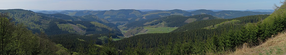
 View from Gelsterhagen mountain (southeast of Altenilpe ) |
|
The Saalhauser mountains are one to 688.5 m above sea level. NHN high mountain range in the Sauerland in the district of Olpe and Hochsauerlandkreis , North Rhine-Westphalia , Germany . They are part of the Rhenish Slate Mountains and belong there to the Southern Mountains .
The namesake of the Saalhauser Berge is Saalhausen (district of Lennestadt ) on the southern edge of the forest area .
geography
location
The Saalhausen Hills lie than by Lenne in the south clearly defined part of Südsauerländer Rothaarvorhöhen (for Südsauerländer Bergland , main unit 336 2 , duly) in Sauerland between Lenne city in West southwest and Schmallenberg in the east-northeast. They extend in the northeast of the Olpe district and south of the Hochsauerlandkreis. Its southwest and central part belongs to the Sauerland-Rothaargebirge nature park . In the northeast the Fredeburger Land borders, in the southeast the Rothaargebirge , in the southwest further parts of the Südsauerländer Rothaarvorrückens, somewhat distant in the west the Ebbegebirge and in the northwest foothills of the Lennegebirge .
The Saalhauser Berge are north of the upper reaches of the Lenne , southeast of its tributary Elspebach and southwest of the upper reaches of the Ruhr tributary Wenne . The western Gleierbach , which flows into the Lenne at Gleierbrück, flows in a north-south direction through the mountains and divides it into a lower western and higher eastern part. The eastern Gleierbach runs slightly to the east of the mountain landscape and approaches the Lenne near Gleidorf .
Natural allocation
The Saalhausen Hills belong to the natural spatial feature unit group Süderbergland (no. 33) in the main unit Südsauerländer mountains (336 2 ) and in the sub unit Südsauerländer Rothaarvorhöhen (336 2 .5) for natural space upper Lenneberg land (336 2 .52).
mountains
The Saalhaus mountains, elevations and their foothills include - sorted by height in meters (m) above sea level (NHN) /:
- Himberg ( 688.5 m )
- Auergang ( 685.6 m )
- Ösenberg ( 678.8 m )
- Hoher Lehnberg ( 668.8 m ), with the remains of the Wallburg Hoher Lehnberg
- Hülsberg ( 662 m )
- Hoher Hagen ( 642.2 m )
- Jürgensberg ( 619.2 m )
- Beerenberg ( 614.1 m ), u. a. with Beerenberg station from Radio Sauerland
- Haferhagen ( 611.4 m )
- Kuhhelle ( 602.6 m ), with a transmission tower
- Bracht ( 599.9 m )
- Hebberg ( 581.1 m )
- Stöppelkopf ( 572 m )
- Bünte ( 552.5 m )
- Eben ( 537.8 m )
- Robecker Berg (approx. 529 m )
- Kahle ( 479.6 m ), with ramparts
- Schmallenberg ( 472.8 m )
Protected areas
The majority of the Saalhauser Berge belongs to the landscape protection area Kreis Olpe ( CDDA -Nr. 345041), which was designated in 1984 and is about 410.83 km², its north-eastern part is part of the 1994 designated and approximately 140.53 km² landscape protection area Rothaargebirge - HSK-Teilflaeche 1 (CDDA No. 323981). Rümperholz nature reserves (also known as Ruemperholz ; CDDA no. 378273), which was designated in 2005 and is about 56.13 hectares in size, and the Ringesbach valley and upper Gleierbach valley (CDDA no. 389875), which was established in 2008, are roughly in the middle of the mountain landscape and Espey (CDDA No. 389722), which was also designated in 2008 and is about 3.4 hectares in size. In their extreme east-northeast, the Saalhauser Berge meet the Lenne valley nature reserve below Schmallenberg (CDDA no. 389818), which was designated in 2008 and covers around 12.19 hectares .
hike
The Christine-Koch-Weg of the Sauerland Mountain Association and the Homertweg cross the mountains from north to south . The Friedrich-Wilhelm-Grimme-Weg opens up the ridge of the Saalhauser Mountains in its entire extension from west to east.
Transport links
North-west of the Saalhauser Berge runs from Grevenbrück in the Elspebach valley, federal road 55 , from which state road 737 branches off to the east near Oedingen . The latter meets the B 236 in Schmallenberg , which leads along the Lenne approximately westwards to Lennestadt and then further northwest to the connection to the B 55 near Grevenbrück; the federal highways connects the L 715 ( Meggen - Elspe / Oberelspe ) in the west of the mountains . From the L 736, the L 928 ( Bracht - Gleierbrück ) branches off in a north-south direction, among other things along the western Gleierbach through the mountains . In its eastern part, the district road 25, which connects the L 737 near Werpe via Harbecke with the B 236, runs in a north-east-south-west direction through the mountain landscape. The B 511 , which connects the aforementioned federal highways between Frielinghausen and Gleidorf, runs a little east of the mountains in the valleys of Leiße (northwest) and eastern Gleierbach (southeast) .
gallery

Beerenberg from the east

Himberg (left) and
Hoher Lehnberg (right) from the north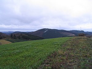
Juergensberg from the northeast
View from Härdler to the Saalhauser mountains

.JPG)


Individual evidence
- ↑ a b Topographical Information Management, Cologne District Government, Department GEObasis NRW ( Notes )
- ↑ a b Map services of the Federal Agency for Nature Conservation ( information )
Web links
- Map / aerial photo of the Saalhauser Berge with borders and all important elevations / placemarks ( Google Earth required)
- BfN landscape profile: South Sauerland red hair advancement