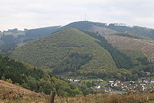
Wallburg Kahle
The Wallburg Kahle is located about 500 m east of Meggen on the 479.6 m high Kahle, one of the 603 m high Kuhhelle hilltop on the right side of the Lenne. The Kahle is 209 meters above the town of Meggen an der Lenne , which forces its way from Altenhundem in a northerly direction to Meggen through the narrow valley and in Meggen bends almost at right angles to the west to flow off towards Maumke and Grevenbrück .
The ascent to the Wallburg takes place from the village of Meggen either over the bird's rod in the northeast of Meggen and from here constantly following the hill in a southerly direction to the castle, or from the Faulebutter (SGV-Hütte Meggen) following the hiking trails in a westerly direction. Both routes lead to the saddle at 462 m .
Geographical location of the Wallburg Kahle
The castle is not located directly on old highways and has belonged to Elspe since time immemorial , the borders of which extended to the mountain ranges of the Lennetal to Altenhundem. The Wallburg Kahle is about 4 km from the old Heidenstrasse and Römerweg , which leads north through the town of Elspe. At a distance of 3.1 km northwest of the Wallburg Weilenscheid ( 482 m ) is at about the same height with a line of sight over the middle Hardt to Wallburg Kahle.
Geological location
Meggen lies in the border area of the Inner Sauerland Depression to the South Sauerland Uplands. The Innersauerland depressions form the Upper Devonian to Lower Carboniferous filling of the Attendorn-Elsper double trough . The alternation of different rocks created a large undulating sequence of ridges and domes running in a south-west to north-east direction, as well as clearing troughs and elongated depressions and hollows. The Meggener Mulde is a special trough located southeast of the double trough and runs on the southern edge of the Elsper Mulde from Meggen via Halberbracht , Burbecke towards Brenschede and Bracht . Below the Kahle "Kahle-Kuhhelle- are provided on the thrust " which resists fuller Orthocrinus layers of Unteremsiums over the younger and less resistive layers of the Eifeliums ( Stöppeler slate , Fredeburger slate and Lenne Light layers ) overthrust been whereby the steep slope explained for Lennetal is.
Description of the plant
Below the saddle, the mountain peak of the Kahle is cordoned off with a rampart up to 2 m high with a recognizable ditch, beginning at a length of about 180 m in front of the Siepen , which flows down to the Wolbecke , over the saddle in a south-westerly direction to the western steep slope Meggen. To the north, the wall was destroyed by a farm road that leads down to the Meggen bird bar. The second wall terrace, about 1.5 m high and a distance between 45 and 26 m from the first, secures the wall castle over a length of 230 m from the northern steep slope towards Halberbracht to the southwestern steep slope towards Meggen. The third wall terrace runs parallel to this with a length of about 150 m, which can only be guessed at in the northern area today. The steep slope of the Kahle to the Lennetal protected the castle to the north and west. Only slight edges can be seen here.
To the southwest of Siepen there is a trench that is around 1.2 m deep today, the upper area of which has apparently been filled in, down to about halfway up Meggen. Two rifle positions from the war can be seen on the hilltop inside the Wallburg, which were dug into the ground here.
All walls were badly damaged by Hurricane Kyrill and the resulting clean-up work.
Archeology of the Wallburg Kahle
So far, no datable finds are known on the area. During excavations from before 1923, a furnace was found in the inner surface of the facility. Still recognizable today are cairns , which are to phosphorus and - manganese-containing limonite from the outcrop of the gear train is the Iron hat.
Age of the Wallburg Kahle
Comparisons with other facilities allow the Kahle to be assigned to the castles of the pre-Roman Iron Age.
D. Beringer divided the Iron Age ramparts in Westphalia into six groups, whereby the topography and the ground plan were decisive as criteria for its classification . He differentiated the systems: “Ring wall in the summit position (A), ring wall on the edge of a plateau (B), ring wall on the hilltop and on a slope (C), ring wall only partially closed (D), ring wall on spur (F) and section fortification Spur (E) ". The Wallburg auf der Kahle therefore belongs to type D fortifications.
Individual evidence
- ^ S. Lukanow: Find chronicle for the Olpe district . 1984, p. 166 .
- ↑ D. Beringer: Behind lock and bolt . Ed .: Landschaftsverband Westfalen-Lippe . 1998, p. 60 .
literature
- S. Lukanow: Chronicle of finds for the Olpe district . 1984.
- Claus Dieter Clausen a. a .: Geological map of North Rhine-Westphalia 1: 25,000. Explanations for sheet 4814 Lennestadt . Krefeld 1978.
- D. Beringer: Under lock and key . Ed .: Landschaftsverband Westfalen-Lippe . 1998.
Coordinates: 51 ° 7 '17.5 " N , 8 ° 4' 33.8" E


