Bracht (Schmallenberg)
|
Brings
City of Schmallenberg
Coordinates: 51 ° 9 '57 " N , 8 ° 9' 54" E
|
||
|---|---|---|
| Height : | 464 (460-490) m | |
| Residents : | 454 (Dec. 31, 2019) | |
| Postal code : | 57392 | |
| Area code : | 02725 | |
|
Location of Bracht in Schmallenberg |
||
|
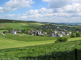
Bracht townscape
|
||
Bracht is a district of Schmallenberg in the North Rhine-Westphalian Hochsauerlandkreis .
geography
Geographical location
Bracht is located north of the Saalhauser Berge on the edge of the Sauerland-Rothaargebirge nature park in the southwest of the Hochsauerlandkreis; The border with the Olpe district runs around 1 km to the west . It is the westernmost district in the Schmallenberg urban area and is around 8.5 km from the city center.
The village is located in a high valley that is surrounded on three sides by mountains (with Saalhauser mountains in the south), is only open to the northeast and in this direction from the Brachter Bach, which rises south of the village and flows through the village, as the left source brook of the Wenne - The Arpe tributary is drained. It is about 460 to 490 m above sea level. NN between mostly wooded elevations of about 480 to 688.5 m above sea level. NN ( Himberg ); This also includes the Bracht mountain, 599.9 m above sea level , located directly to the southwest . NN .
In the center of the village, Landesstraße 928 ( Oedingen –Schmallenberg) branches off from the L 737; it leads, especially running in the Gleierbach valley, to Gleierbrück (eastern district of Lennestadt ), which is about 5 km south of Bracht beyond the Saalhauser mountains.
Around the village lies the landscape protection area outskirts of Bracht .
Neighboring places
Villages and hamlets in the area are ( clockwise ): Herschede (north-north-east), Kückelheim (north-east), Werntrop (east-south-east), Saalhausen and Gleierbrück (south), Rotbusch and Hebbecke (south-west), Brenschede (west), Oedingen with Oedingerberg (north-west ) and Leckmart (north-northwest).
history
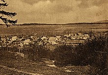
In the absence of documents, it is not possible to determine the exact time when Bracht was founded. The brothers Richard and Dietrich von Bracht were first mentioned in a document from the later Count Wilhelm von Arnsberg from 1306.
In 1490 there was a Gut Bracht owned by the von Schledorn family . Johann von Schledorn married Anna von Ploch-Iseren from an equally old knight family ("iseren armigi") in 1522, and so came to the Plochhof in Oberveischede . The Bracht estate was inherited by his eldest daughter. As early as 1536 the taxable population of Brachter was recorded by name in the treasury register. In 1645 Bracht was mapped on the Westphalia Ducatus map.
Until the municipal reorganization in North Rhine-Westphalia, Bracht (in the so-called Hawerland) belonged to the municipality of Wormbach . Since January 1st, 1975 Bracht has been part of the town of Schmallenberg.
The place is at a crossroads of Heidenstrasse from Cologne via Elspe , Bracht, Wormbach to Kassel and the Kriegerweg from Siegen. The latter led over the stone cross through the Gleiertal and was controlled by the Bilstein court with a blow (turnpike at Christes Hude). The old traffic route leads over the Wehrscheid to the town of Bracht, where it is sealed off with a Landwehr and turned off to the customs office on Heidenstraße. The "Kriegerweg" crossed Heidenstrasse west of the town before the Schlag and continued north via Herschede and Oberlandenbeck . In Urkataster are corridor designations Landwehr and stroke remain. In the locality, the land forces around the place can still be seen in places as deep trenches with walls. The judicial districts of Fredeburg and Bilstein separated in the Gleie, the court of Oedingen with Fredeburg above the Limmecke before Brenschede.
During the air raid on Bracht on April 8, 1945, large parts of the village, especially the school (Christine Koch School) and the church, were destroyed.
religion
In Bracht there is the Catholic parish of St. Marien with the church of the same name.
Public facilities
There is a kindergarten and an inn in the village.
Events in the year
Sports festival (Sportverein BVB Bracht), Schützenfest (every second weekend in July from the Schützenverein), wheat beer festival, Father's Day meeting on Ascension Day (SGV hut), May 1st celebration (SGV hut)
economy
The largest employer in town is an anodizing company that refines the surfaces of aluminum components. There is also a car accessories trade, transport and building materials company, a geothermal company and a carpentry shop. The Stadtsparkasse Schmallenberg and a building society have a branch here. There are also agricultural and craft businesses based in Bracht.
Personalities
- Franz Geueke (1887–1942), journalist and resistance fighter against National Socialism
- Christine Koch (1869–1951), poet in Sauerland dialect. A hiking hut named after her is located 1 km from the site. In 2007 a Christine Koch memorial was erected in the village.
- Franz Joseph Koch (1875–1947), teacher and author
literature
- Josef Lauber: Stammreihen Sauerland families, Volume V, Parish Wormbach , Bracht, p. 4, Richard Schwarzbild dissertation print Witterschlick near Bonn, 1977
Web links
- WDR film from Bracht (Real Player)
- Bracht (Schmallenberg) in the Westphalia Culture Atlas
Individual evidence
- ↑ Population figures Schmallenberg 2019 , accessed on June 30, 2020
- ↑ Topographical Information Management, Cologne District Government, Department GEObasis NRW ( Notes )
- ↑ Bracht-werngtrop.de: excerpt from the story of Bracht, village club Bracht-Werntrop eV accessed on November 12, 2018
- ↑ Plettenberg-lexikon.de: Johann I. von Schledorn (Schleden zu Bracht) , accessed on February 10, 2016.
- ↑ Gedbas.genealogy.net: Johann Schleden zu Bracht , accessed on February 10, 2016.
- ^ Josef Lauber: Stammreihen Sauerland Families, Volume V, Parish Wormbach , p. 4
- ^ Federal Statistical Office (ed.): Historical municipality directory for the Federal Republic of Germany. Name, border and key number changes in municipalities, counties and administrative districts from May 27, 1970 to December 31, 1982 . W. Kohlhammer, Stuttgart / Mainz 1983, ISBN 3-17-003263-1 , p. 335 f .
- ^ The last Generalschnadezug around the official Bilstein sovereign and state border from June 8th to 17th, 1778, in particular the 15th and 18th centuries. June 16.


