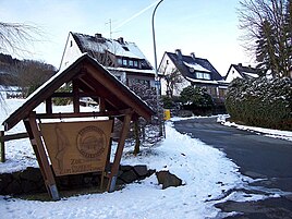
Heiminghausen
|
Heiminghausen
City of Schmallenberg
Coordinates: 51 ° 11 ′ 45 " N , 8 ° 15 ′ 41" E
|
||
|---|---|---|
| Height : | 380 m above sea level NN | |
| Residents : | 102 (Dec. 31, 2019) | |
| Postal code : | 57392 | |
|
Location of Heiminghausen in Schmallenberg |
||
|
Heiminghausen
|
||
Heiminghausen is a district of the city of Schmallenberg in North Rhine-Westphalia .
geography
The small village is located about 4 km northwest of Schmallenberg at an altitude of 380 m above sea level. NN. The Leiße flows through the village .
Neighboring places are Berghausen , Mailar and Niederberndorf .
History and religion
In 1392 the Feldmann Hof zu Heiminghausen was an old colonial estate of the noblemen of Grafschaft . In 1491 Mandt Waldschmidt (Waltmet) headed a free court and was free count in Heiminghausen. In 1645 Hemkhusen was mapped on the Westphalia Ducatus map. Until the municipal reorganization in North Rhine-Westphalia, Heiminghausen belonged to the municipality of Berghausen. Heiminghausen has been part of the town of Schmallenberg since January 1, 1975.
The Luzia Chapel, inaugurated on November 7, 1813, is located in Heiminghausen.
economy
Several craft u. Service companies are rooted in the place. There is a blacksmith's shop, a carpentry shop, a carpenter's shop, a gardening shop, a pallet construction company, an electronics company, a bus company, a slate mine with healing caves , a packaging company, a forest and forestry company.
traffic
Heiminghausen is on the B511, which connects Bremke with Gleidorf. Between 1911 and 1967, the place had its own train station, which had two continuous tracks and a loading platform at the goods shed. The station was on the former railway line from Wennemen to Altenhundem. The Wennemen-Altenhundem railway line was closed for passenger traffic on May 28, 1967 and the station was closed. The station building was demolished in the late 1980s. Freight traffic continued on the Wennemen-Schmallenberg route until December 29, 1994. After goods traffic had also ceased, the railway line was converted into the so-called SauerlandRadring , a national cycle route. The SauerlandRadring was opened in 2007.
literature
- Josef Lauber: Stammreihen Sauerland families, Volume IV, parish Berghausen - Fleckenberg - Lenne , Heiminghausen, p. 63, Richard Schwarzbild dissertation print Witterschlick near Bonn, 1977
Web links
- Heiminghausen in the Westphalia Culture Atlas
Individual evidence
- ↑ Population figures Schmallenberg 2019 , accessed on June 30, 2020
- ^ Federal Statistical Office (ed.): Historical municipality directory for the Federal Republic of Germany. Name, border and key number changes in municipalities, counties and administrative districts from May 27, 1970 to December 31, 1982 . W. Kohlhammer, Stuttgart / Mainz 1983, ISBN 3-17-003263-1 , p. 335 f .


