County (Schmallenberg)
|
county
City of Schmallenberg
Coordinates: 51 ° 8 ′ 45 ″ N , 8 ° 19 ′ 31 ″ E
|
||
|---|---|---|
| Height : | 410 m above sea level NN | |
| Residents : | 1096 (Dec. 31, 2019) | |
| Incorporation : | 1st January 1975 | |
| Postal code : | 57392 | |
|
Location of Grafschaft in Schmallenberg |
||
|
Aerial photo (2013)
|
||
Grafschaft is a district of the city of Schmallenberg . Since 1974, the county is a state-approved health resort and since 2002 health resort . The federal gold village has 1096 inhabitants.
geography
location
Grafschaft is 3 kilometers east of Schmallenberg at the foot of the Wilzenberg at approx. 410 meters above sea level. The river Grafschaft flows through the village . Schanze and Latrop belong to the parish of Grafschaft. The landscape protection area Offenlandmulde Grafschaft - Almert and the landscape protection area Talraum der Grafschaft and side valleys are located around Grafschaft .
Neighboring places
Neighboring places are Schanze , Schmallenberg, Gleidorf , Winkhausen , Almert , Störmecke and Latrop .
history
The name Grafschaft is derived from the field name "Graskap", d. H. "Grass tip". This should probably refer to the place where the Benedictine abbey , founded in 1072 , was built, or one of the surrounding grassy hills.
There is also a name reference to the noble family of the noble lords of Grafschaft (then "von Grascap"). After the founding of the Grafschaft monastery, the Grafschafter noblemen became hereditary guardians of the monastery. They later built their ancestral castle in Nordenau on Heidenstrasse (today's Rappelstein castle ruins ). There is no evidence that the noble lords of Grafschaft previously had their seat on Wilzenberg. In the 16th century, the von Glascap family died out.
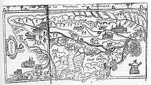
The place is first mentioned in 1072 in connection with the foundation of the monastery. Whether a village called Grafschaft already existed at that time cannot be proven on the basis of written records. For this reason, it is not possible to give an exact number of farms in Grafschaft around 1072. Based on the court mentions of the 13th and 14th centuries, there should have been between one and four farms. The first written mention of the place dates from the year 1283. For the period up to 1400 at least seven farms can be found in the county, 100 years later there are ten. By 1660 the number of farms grew to 17. All farms belonged to the Grafschaft monastery and were subject to tax. In 1645 Gravelcop was mapped on the Westphalia Ducatus map.
In the course of secularization in 1803, the Grafschaft monastery was abolished and taken over by the new sovereign, the Landgrave, later Grand Duke of Hesse-Darmstadt . In 1816, like the entire Sauerland , the county fell to the Kingdom of Prussia . In 1843 the political municipality Grafschaft, to which the places Gleidorf , Latrop and Schanze belonged, was established. In 1851 and 1852 two major fires destroyed a third of the houses in the village. In addition to the traditional occupation, agriculture, handicrafts and activities in the service sector determined the working life of the place in the 19th and 20th centuries. Tourism gained increasing importance in the 20th century. Today the county is a popular vacation spot. This development was promoted by the competition “ Our village should become more beautiful ”. At the federal competition in 1965, Grafschaft was awarded the gold plaque.
In 1920 the municipality Grafschaft lost an area of 8.55 km² to form the new municipality Fleckenberg .
In the course of the local reorganization, the political municipality Grafschaft was incorporated into the new town of Schmallenberg on January 1, 1975.
politics
coat of arms

|
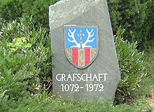
Blazon : Divided by blue and gold; above a gold cross made of six diamonds, accompanied by two silver stag poles, below two red posts. Description: Both heraldic images were used in the coat of arms of the abbots of Grafschaft. The upper part comes from the coat of arms of the Counts of Dassel , the lower part of the coat of arms of the extinct noble lords of Grafschaft who were monastery bailiffs until 1572. The county coat of arms was officially approved on December 10, 1951. |
religion
The single-nave, three-bay church from the 18th century was demolished in 1962. At the same place in front of the monastery, today's parish church of St. George was built in 1963/1964.
Facilities
Grafschaft is the seat of the Grafschaft monastery specialist hospital and the Fraunhofer Institute for Molecular Biology and Applied Ecology (since 1959).
education
There is a public Catholic library and a kindergarten in the village.
Attractions
There are 185 monuments in the Schmallenberg urban area. Some of them are in the county. The list of architectural monuments in Schmallenberg lists the architectural monuments with a brief description. The main attractions include:
- Monastery county ; The west portal with the Anno statue and the museum in the north wing are particularly worth seeing .
- Wilzenberg ; Remains of a prehistoric hill fort; Pilgrimage chapel from 1633; There is an observation tower on the summit (658 m) .
→ See also: List of natural monuments in Schmallenberg
Others
Grafschaft won federal gold in the competition “ Our village should be more beautiful ” in 1965 .
Personalities
Honorary citizen
- Mayor Paul Kloidt was granted honorary citizenship in 1974.
literature
- Josef Wiegel (Hrsg.): Grafschaft - Contributions to the history of monastery and village , Verlag Heimat and Förderverein Grafschaft-Schanze, 2nd expanded edition, 1997
Web links
- Grafschaft-Schanze.de
- Grafschaft-Tourismus.de
- Grafschaft (Schmallenberg) in the Westphalian Cultural Atlas
Individual evidence
- ↑ Population figures Schmallenberg 2019 , accessed on June 30, 2020
- ↑ Michael Flöer: The place names of the Hochsauerlandkreis, Bielefeld 2013, pp. 190–191 ISBN 978-3-89534-946-1
- ^ Günther Becker: The village of Grafschaft and its courtyards up to the middle of the 19th century from Grafschaft - Contributions to the history of monastery and village, p. 110, 1997
- ↑ Stephanie Reekers: The regional development of the districts and communities of Westphalia 1817-1967 . Aschendorff, Münster Westfalen 1977, ISBN 3-402-05875-8 , p. 237 .
- ^ Federal Statistical Office (ed.): Historical municipality directory for the Federal Republic of Germany. Name, border and key number changes in municipalities, counties and administrative districts from May 27, 1970 to December 31, 1982 . W. Kohlhammer, Stuttgart / Mainz 1983, ISBN 3-17-003263-1 , p. 335 f .
- ^ Eduard Belke, Alfred Bruns, Helmut Müller: Kommunale Wappen des Herzogtums Westfalen, Arnsberg 1986, p. 149 ISBN 3-87793-017-4


