
Werntrop
|
Werntrop
City of Schmallenberg
Coordinates: 51 ° 9 ′ 32 " N , 8 ° 11 ′ 46" E
|
||
|---|---|---|
| Height : | 430 m | |
| Residents : | 66 (Dec. 31, 2019) | |
| Postal code : | 57392 | |
Location of Werntrop in Schmallenberg |
||
 Werntrop
|
||

Werntrop is a district of the city of Schmallenberg in North Rhine-Westphalia .
geography
location
The village is located about 6 km west of Schmallenberg at the foot of the Ösenberg at an altitude of 419 m above sea level. Country road 737 runs through Werntrop. The open land complex Werntrop / Selkentrop / Felbecke is located around the village .
Neighboring places
Adjacent places are Bracht , Kückelheim , Selkentrop and Felbecke .
history
When the Grafschaft monastery was founded in 1072, Werntrop was also mentioned in a document for the first time. There is also evidence that the von Heygen family from Heggen owned properties in Werntrop in the 14th century.
Until the local reorganization in North Rhine-Westphalia, Werntrop belonged to the municipality of Wormbach in the so-called Hawerland. Since January 1st, 1975 Werntrop has been part of the town of Schmallenberg.
Chapel of St. Agatha
The St. Agatha chapel is located on the “cold courtyard” in Werntrop . The renaissance style chapel with 3/8 end, round-arched windows with lead glazing and an octagonal roof turret was built in the middle of the 17th century. A previous chapel was mentioned before the 16th century. The altar in the chapel is from the time it was built. Shown are left, the Holy. Agatha , the right of St.. Nicholas . In the middle is a Gothic Pietà from the 15th century. The wall cross on the left is from the 13th century. It was restored inside and out in 1988/89.
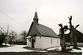
Chapel of St. Agatha Werntrop

Altar in the chapel

13th century cross


Werntrop mill

The Bruchbach , which rises below the Hülsberg and the Auergang, as well as the springs rising in the meadows, fed the former mill pond of the Werntrop mill below the village. This mill is located within the Landwehr, which secured the Heidenstrasse to the north. You can still see it today from the saddle of the Kahlenberg near Bracht, including the mill, crossing the Bruchbach, over the saddle, also crossing the Hagensiepen , below the Grüneberg to the current L737 road. The Heidenstraße runs almost parallel to this through the village, over the Ostenberg towards Wormbach .
literature
- Josef Lauber: Stammreihen Sauerland families, Volume V, Parish Wormbach , Werntrop, p. 259, Richard Schwarzbild dissertation print Witterschlick near Bonn, 1978
Web links
Individual evidence
- ↑ Population figures Schmallenberg 2019 , accessed on July 3, 2020
- ↑ The von Heygen family ( Memento of the original from September 27, 2007 in the Internet Archive ) Info: The archive link was inserted automatically and has not yet been checked. Please check the original and archive link according to the instructions and then remove this notice. (PDF; 617 kB)
- ^ Federal Statistical Office (ed.): Historical municipality directory for the Federal Republic of Germany. Name, border and key number changes in municipalities, counties and administrative districts from May 27, 1970 to December 31, 1982 . W. Kohlhammer, Stuttgart / Mainz 1983, ISBN 3-17-003263-1 , p. 335 f .
- ^ Weber, Bruns, 2002, Buildings and Art Monuments of the City of Schmallenberg, Volume 2, page 61
- ^ Hömberg, AK, 1967, Heimatchronik des Kreis Olpe, page 52

Almert | Altenhof | Altenilpe | Arpe | Bad Fredeburg | Berghausen | Berghof | Bödefeld | Brabecke | Bracht | Dorlar | Dornheim | Ebbinghof | Felbecke | Fleckenberg | Föckinghausen | Gellinghausen | Gleidorf | County | Grimminghausen | Hanx leather | Harbecke | Lifting basin | Heiminghausen | Herschede | Hiege | High bone | Holthausen | Dog sauces | Huxel | Indian hen | Hunting lodge | Keppel | Kirchilpe | Kirchrarbach | Kückelheim | Landenbeckerbruch | Lanfert | Latrop | Lengenbeck | Lenne | Mailar | Menkhausen | Middle sorpe | Monk child | Nesselbach | Niederberndorf | Niederhenneborn | Niedersorpe | Kidney drop | Nordenau | Oberberndorf | Oberhenneborn | Oberkirchen | Oberrarbach | Obersorpe | Obringhausen | Ohlenbach | Osterwald | Rehsiepen | Rellmecke | Rimberg | Red bush | Jump | Selkentrop | Sellinghausen | Sellmecke | Silberg | Sögtrop | Sonderhof | Störmecke | Twismecke | Forest | Waidmannsruh | Walbecke | Werntrop | Werpe | Westernbödefeld | Westfield | Winkhausen | Wormbach | Wulwesort