
Obersorpe
|
Obersorpe
City of Schmallenberg
Coordinates: 51 ° 11 ′ 53 " N , 8 ° 23 ′ 46" E
|
||
|---|---|---|
| Height : | 518 m above sea level NN | |
| Residents : | 51 (Dec. 31, 2019) | |
| Postal code : | 57392 | |
Location of Obersorpe in Schmallenberg |
||
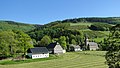
 Obersorpe in spring 2010
|
||

.jpg)
Obersorpe is a district of the city of Schmallenberg in North Rhine-Westphalia .
geography
location
Obersorpe is about 6 km east of Bad Fredeburg and 1 km south of the Hunau (818 m) at 518 m above sea level. The Sorpe , which gave the place and other places in the Sorpe Valley its name, flows through the village. The Hunausiepen flows into the Sorpe in the village.
Neighboring places
Neighboring places are Rehsiepen and Mittelorpe .
history
In 1072 Sorpe (then Suropo) was first mentioned in a deed of the monastery Grafschaft . It is not clear whether this meant Obersorpe, the entire Sorpe Valley or only Niedersorpe. In 1645 Overen Sarepe was mapped on the Westphalia Ducatus map. The oldest structure in the village is a farm that was built around 1700. In 1895, 83 residents lived in Obersorpe, according to the entry in the trade and business address book of the Province of Westphalia. The place belonged to the municipality of Oberkirchen until the municipal territorial reform in North Rhine-Westphalia. Since January 1st, 1975 Obersorpe has been part of the extended town of Schmallenberg.
religion
The parish church of St. Joseph was built in 1897. The church tower clock is a war memorial for the twelve fallen soldiers of the First World War .
economy
There are farms and restaurants in Obersorpe.
The Church of St. Joseph in Obersorpe

SGV refuge Obersorpe in the "Schipp Siepen"
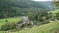
View of Obersorpe in autumn 2010


Web links
- Obersorpe
- Obersorpe in the Westphalia culture atlas
Individual evidence
- ↑ Population figures Schmallenberg 2019 , accessed on July 3, 2020
- ^ Alfred Bruns: Court and Parish Oberkirchen , p. 461, Stadt Schmallenberg (ed.), 1981
- ^ Federal Statistical Office (ed.): Historical municipality directory for the Federal Republic of Germany. Name, border and key number changes in municipalities, counties and administrative districts from May 27, 1970 to December 31, 1982 . W. Kohlhammer, Stuttgart / Mainz 1983, ISBN 3-17-003263-1 , p. 335 f .

Almert | Altenhof | Altenilpe | Arpe | Bad Fredeburg | Berghausen | Berghof | Bödefeld | Brabecke | Bracht | Dorlar | Dornheim | Ebbinghof | Felbecke | Fleckenberg | Föckinghausen | Gellinghausen | Gleidorf | County | Grimminghausen | Hanx leather | Harbecke | Lifting basin | Heiminghausen | Herschede | Hiege | High bone | Holthausen | Dog sauces | Huxel | Indian hen | Hunting lodge | Keppel | Kirchilpe | Kirchrarbach | Kückelheim | Landenbeckerbruch | Lanfert | Latrop | Lengenbeck | Lenne | Mailar | Menkhausen | Middle sorpe | Monk child | Nesselbach | Niederberndorf | Niederhenneborn | Niedersorpe | Kidney drop | Nordenau | Oberberndorf | Oberhenneborn | Oberkirchen | Oberrarbach | Obersorpe | Obringhausen | Ohlenbach | Osterwald | Rehsiepen | Rellmecke | Rimberg | Red bush | Jump | Selkentrop | Sellinghausen | Sellmecke | Silberg | Sögtrop | Sonderhof | Störmecke | Twismecke | Forest | Waidmannsruh | Walbecke | Werntrop | Werpe | Westernbödefeld | Westfield | Winkhausen | Wormbach | Wulwesort