Dornheim (Schmallenberg)
|
Dornheim
City of Schmallenberg
Coordinates: 51 ° 14 ′ 55 ″ N , 8 ° 20 ′ 13 ″ E
|
||
|---|---|---|
| Height : | 495 m | |
| Residents : | 38 (Dec. 31, 2019) | |
| Postal code : | 57392 | |
| Area code : | 02971 | |
|
Location of Dornheim in Schmallenberg |
||
|
Dornheim
|
||
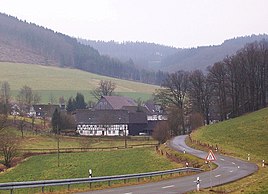
Dornheim is a district of the city of Schmallenberg in North Rhine-Westphalia .
geography
location
Dornheim is located about four kilometers west of the Schmallenberg district of Bödefeld . The Ehrenberg ( 621.6 m ) rises to the northwest and the Bracht ( 725.7 m ) to the south-southeast . The Doorne (Dornheimer Bach) flows through the village as a tributary of the Kleiner Henne . The nature reserve open land areas around Dornheim is located around the village .
Neighboring places
The neighboring places are Hanxleden , Föckinghausen , Kirchrarbach , Bonacker and Westernbödefeld .
history
The village belonged to the municipality of Rarbach until the municipal reform . On January 1, 1975, Dornheim became a district of Schmallenberg.
religion
The St. Hubertus Chapel, built in 1892, is located in the village.
Personalities from Dornheim
- Theresia Albers (born August 5, 1872 in Dornheim, † January 21, 1949 in Hattingen- Bredenscheid ) was a teacher and founder of the order.
Individual evidence
- ↑ Population figures Schmallenberg 2019 , accessed on June 30, 2020
- ^ Federal Statistical Office (ed.): Historical municipality directory for the Federal Republic of Germany. Name, border and key number changes in municipalities, counties and administrative districts from May 27, 1970 to December 31, 1982 . W. Kohlhammer, Stuttgart / Mainz 1983, ISBN 3-17-003263-1 , p. 335 f .


