Himberg (Saalhauser Mountains)
| Himberg | ||
|---|---|---|
|
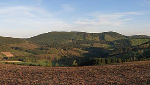
Himberg (left) and Hoher Lehnberg (right) from the north |
||
| height | 688.5 m above sea level NHN | |
| location | near Saalhausen ; Hochsauerlandkreis , Olpe District , North Rhine-Westphalia ( Germany ) | |
| Mountains | Saalhaus mountains | |
| Dominance | 5.8 km → Härdler ( Rothaargebirge ) | |
| Notch height | 256.6 m ↓ Schmallenberg -N | |
| Coordinates | 51 ° 8 ′ 19 ″ N , 8 ° 10 ′ 6 ″ E | |
|
|
||
| particularities | Highest point in the Saalhaus mountains | |
The Himberg is 688.5 m above sea level. NHN the highest point in the Saalhauser Mountains in the Sauerland . It is located in the Hochsauerlandkreis and in the Olpe district in North Rhine-Westphalia .
geography
location
The Himberg rises roughly in the center of the Saalhauser Berge in the Sauerland-Rothaargebirge nature park . The border between the Hochsauerlandkreis in the north and the Olpe district in the south runs across the summit region. The summit is in the Saalhausen district around 2 km north of the Lennestadt village and around 3 km south of Bracht , a district of Schmallenberg .
The difference in altitude to the Lenne valley south of the Himberg is 375.5 m with an average slope of 16% down to the river in Saalhausen, which runs at an average height of 313 m . On the mountain slopes, among others springing Rinsenbergbach (Saßmecke) , the Spinkacker Bach , the Lehnbergsiepen (Lehnbornquelle) , the rings Bach and the black plug Siepen . Its west -south-west shoulder is formed by the Hohe Lehnberg ( 668.8 m ), on which the remains of the Hoher Lehnberg castle are located, and its south-south-west foothill is the Rinsenberg ( 634.4 m ), whose south-south-west slope rises from the Rinsleyfelsen ( 559.2 m ).
Natural allocation
The Himberg belongs to the natural spatial main unit group Süderbergland (No. 33), in the main unit Südsauerländer Bergland (336 2 ) and in the subunit Südsauerländer Rothaarvorhöhen (336 2 .5) to the natural area Oberlennebergland (336 2 .52).
Landscape protection
Parts of the landscape protection areas Elsper Senke-Lennebergland (type A) ( CDDA no. 555555270; designated 2006; 71.9952 km² ) extend on the Himberg in the south and Rothaargebirge (Hochsauerlandkreis subarea 1) (CDDA no. 555555133; 1984; 140.3369 km²) in the north.
Economy and forest
The Himberg is used for forestry and is mainly forested with spruce . The summit region is covered by a strip of beech forest, which for a long time towered over the surrounding, younger spruce forest and gave the mountain its characteristic appearance. In the meantime, however, the spruce trees have grown so far that the beeches barely protrude over them.
hike
The Christine-Koch-Weg of the Sauerland Mountain Association and the Homertweg lead over the Himberg , which run with an identical route west of the summit region over the saddle leading to the Hohen Lehnberg .
Individual evidence
- ↑ a b Topographical Information Management, Cologne District Government, Department GEObasis NRW ( Notes )
- ↑ GeoServer NRW, District Government Cologne, Department GEObasis NRW German base map 1: 5000, gap is 431.9 m
- ↑ Martin Bürgener: Geographical Land Survey: The natural spatial units on sheet 110 Arnsberg. Federal Institute for Regional Studies, Bad Godesberg 1969. → Online map (PDF; 6.1 MB)
- ↑ Map services of the Federal Agency for Nature Conservation ( information )

