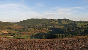
High Lehnberg
| High Lehnberg | ||
|---|---|---|
|
View from the Bracht in the north to the Himberg (left) with its west-southwest shoulder Hoher Lehnberg (right) |
||
| height | 668.8 m above sea level NHN | |
| location | near Saalhausen ; District of Olpe , North Rhine-Westphalia ( Germany ) | |
| Mountains | Saalhaus mountains | |
| Coordinates | 51 ° 8 '11 " N , 8 ° 9' 26" E | |
|
|
||
| particularities | Wallburg Hoher Lehnberg | |
The Hohe Lehnberg is 668.8 m above sea level. NHN high west-southwest shoulder of the Himberg in the Saalhauser mountains . Belonging to the Sauerland , it is located in the Saalhausen district in the North Rhine-Westphalian district of Olpe . The Wallburg Hoher Lehnberg is located on the mountain .
geography
location
The Hohe Lehnberg rises in the eastern part of the Saalhauser Berge and belongs to the Sauerland-Rothaargebirge nature park . Its summit is about 3.2 km south of the Schmallenberg district of Bracht , about 2 km north of the Lennestädter district of Saalhausen and about 750 m west-southwest of the Himberg summit. Other villages near the mountain are Werntrop (north-east), which belongs to Schmallenberg, Burbecke (north-west), Brenschede (north), Gleierbrück (south-south-west) and Stöppel (west -south- west), which all belong to Lennestadt.
The Rothaar Mountains extend south-east of the Hohen Lehnberg or the Saalhauser Berge and thus south-east of the Lenne valley . About 330 m northeast of its summit is the natural monument of the Lehnborn spring , which feeds the Lehnbergsiepen . Its water flows around the mountain in a left curve and then runs through the Gleierbach mostly southwards into the Lenne. The south-west flowing Gleierbach tributary Spinkacker Bach rises on the southern flank .
On the summit region of the High Lehnberges ( 668.8 m ) is a trigonometric point ( 666.8 m ).
Natural allocation
The Hoher Lehnberg belongs to the natural area main unit group Süderbergland (No. 33), in the main unit Südsauerländer Bergland (336 2 ) and in the subunit Südsauerländer Rothaarvorhöhen (336 2 .5) to the natural area Oberlennebergland (336 2 .52).
Landscape protection
Parts of the landscape protection area (NSG) Elsper Senke-Lennebergland (type A) ( CDDA -Nr. 555555270; designated 2006; 71.9952 km² ) extend on the Hohen Lehnberg , to which those of the NSG Rothaargebirge (Hochsauerlandkreis subarea ) are located northeast of the Lehmborn spring 1) (CDDA no. 555555133; 1984; 140.3369 km²).
Wallburg Hoher Lehnberg
On the summit of the Hohen Lehnberg there are wall and moat remains of a hill fort . The facility consists of a semicircular wall, which leans with its open south side against the steep slope of the mountain. There is also a gate security. The inner area with a previously existing small castle is about 90 × 50 meters.
The facility served to protect and monitor the Kriegerweg leading through the Gleierbachtal , which leads from Siegen to Paderborn and can be regarded as one of the few old north-south roads in the Sauerland.
hike
The Christine-Koch-Weg of the Sauerland Mountain Association and the Homertweg lead over the saddle between the Hohen Lehnberg and the Himberg - there with the same route .
Individual evidence
- ↑ a b c d Map services of the Federal Agency for Nature Conservation ( information )
- ↑ Topographical Information Management, Cologne District Government, Department GEObasis NRW ( Notes )
- ↑ Martin Bürgener: Geographical Land Survey: The natural spatial units on sheet 110 Arnsberg. Federal Institute for Regional Studies, Bad Godesberg 1969. → Online map (PDF; 6.1 MB)
- ^ Entry on Saalhausen (Hoher Lehnberg) in the private database "Alle Burgen".
- ↑ Documentation of the entry of the Hoher Lehnberg ramparts in the monument list PDF

