Warrior way
The warrior route was a prehistoric and medieval trade route in the area of the Siegerland and the Sauerland . He combined victories with Paderborn .
course
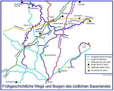
Just as old as the Heidenstrasse and the Römerweg is the so-called Kriegerweg, which climbs from Siegerland in a north-easterly direction through Hilchenbach and "Hinter der Hecke" past "Am Wachthäuschen" to the "Albaumer Höhe" to cross the border of the Siegerland. Following this ridge, he passes the Schartenberge, where there was a camp, above the saddle at the "Kellerbruch", where a road barrier secured the road, and leaving Brachthausen on the left to the saddle under the "Höchst". Past the "Brachthauser Klippen" on the Ellenborn, it leads over the ridge to the "Stüvelhagen" and from here over the "Krähenpfuhl" past the execution places of the Bilstein blood court into the valley of theHundem . Leaving the Königsberg on the right and crossing the Hundembach at Würdinghausen , the road now leads "Am Ringhagen" above Haus Bruch to the height of the Dürrenberg and from here to the "Stone Cross". From there it goes steeply down the Rennacken in the bends of the mountain climbs to cross the Lenne at Totenohl and Christes Hammer (in the 18th century a hammer mill for iron processing, powered by water power) in today's village of Gleierbrück .
Nearby is the field name "Deitfert", which indicates a ford in the Lenne before there is a bridge, cf. By the way .
The Kriegerweg continues through the narrow Gleietal valley below the ramparts of the "Hohen Lehnberg" up to the Brachter Höhe over the Wehrscheid to Bracht, where it crosses Heidenstrasse.
This old road, which was built in prehistoric times, was cordoned off in the Gleie by a blow (from turnpike = customs office). The former loft "near Christes Hude" can still be seen today in the meadow area. Today's borders between the city of Lennestadt and the city of Schmallenberg still pay tribute to the conditions at that time with a swerve around the loft. In Bracht, the field names “Wehrscheid” or “ Landwehr ” as well as “Lamfert” and “Schlag” are reminiscent of the old days when the street was still important. Before the village of Bracht, she was at least temporarily led to the "present" place on the Heidenstrasse , before which she crossed it, to continue over the saddle in the direction of Herschede over the "dürren Hahn" and "Am Stockwege" to Oberlandenbeck . Here it leads through the "Salmecke" (perhaps from Saalhof?) Along the "Speisert" mountain in the direction of Lochtrop .
The Gau Lochtrop already appears in the document from Elspe and Oedingen in the year 1000, in which Emperor Otto III. (HRR) , the convent Oedingen confirmed. Before Lochtrop on the "Baukhan", the traces of the warrior path and the associated weirs can still be clearly seen in the area. Past the village of Frielinghausen, along the Wenne, the route continued to Bremke , where, together with the Römerweg on the opposite side of the mountain, slowly climbed the Reister Berger. Passing the natural monument “Adam and Eve”, we continue along the ridge towards Meschede .
The Meschede-Schüren airfield was later built on the ridge between Bremke and Meschede, on which the Kriegerweg runs . When we arrived in Meschede, the path led north-east through the Gebketal. Below today's A 46 motorway, the path changed sides of the river and rose steeply to Schnettenberg (north of Eversberg), as can still be seen today from the sunken paths .
In the further course the Kriegerweg climbs up to the "Warsteiner Kopf" (548 m above sea level). Here the Kriegerweg crossed with the Plackweg . After the crossing, the path led down again with clearly visible traces into the Lörmeckal valley, and after crossing a ford it climbed again to the "Budeusbuche". The path then runs over the ridge between Langer Bach and Lörmecke . Even on this incline, several ravines can still be seen next to each other, which the teams left behind over the course of history. To the southeast of Warstein, the path leaves today's edge of the forest and crosses the Waschebach with a ford. From here the Kriegerweg led via Schloss Körtlinghausen towards Rüthen and on to Paderborn .
literature
- Home chronicle of the district of Olpe, AK Hömberg 1958
- various native voices from the Olpe district
- German base maps M1: 5000 Land Survey Office NRW


