Natural path victory
| Natural path victory |
|
|---|---|
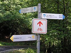
 Signpost on the Natursteig Sieg |
|
| Data | |
| length | 196.4 km |
| location | along the Sieg , in the Rhein-Sieg district ( North Rhine-Westphalia ) and the district of Altenkirchen ( Rhineland-Palatinate ) |
| Markers | |
| Starting point |
Siegburg / Bonn train station 50 ° 47 ′ 38.9 ″ N , 7 ° 12 ′ 11.1 ″ E |
| Target point | Mudersbach train station (currently) 50 ° 49 ′ 38.7 ″ N , 7 ° 57 ′ 5.6 ″ E |
| Type | trail |
| The highest point | Lookout point at Steinerother Kopf ( 453 m above sea level ) (currently) |
| Lowest point | Siegburger Mühlengraben ( 56 m above sea level ) |
| Level of difficulty | light |
| season | all year round |
| Viewpoints | Steinerother head , Otto tower , old chair |
| particularities | Premium hiking trail |
The Natursteig Sieg is a long-distance hiking trail that was opened in April 2011 and leads 196.4 km in North Rhine-Westphalia and Rhineland-Palatinate through the Rhein-Sieg district and the Altenkirchen district . It begins in the Siegburg district of Wolsdorf and connects cities and towns on the Sieg (for the time being) to Mudersbach train station .
The climb was chosen so that the individual stages can be easily reached by public transport from Cologne , Troisdorf and Siegen via the stops on the Siegtal route . The Steig has been a certified hiking trail since 2013 . It is possible to purchase a stamp pass and fill it up at the various stamping points along the path.
The continuation of the climb in three further stages towards the Siegquelle near Netphen is in planning ; the climb should then be over 250 km long. The establishment of the signposting for these new stages was originally supposed to be completed in August 2019; implementation is currently being pursued by summer 2020.
Waymarks
The signpost (or hiking sign) of the natural trail Sieg shows the turns of the Sieg in white on a blue background. The access routes have the same sign, but white on a yellow background.
course


The nature riser victory begins at station Siegburg / Bonn (about 57 m ) and from there along the first Siegburger Mühlengraben (about 56 m ) to the district in Siegburger Wolsdorf lying Wolsbergen (about 115 m ). Then it runs through Hennef and past the Wahnbachtalsperre to Seligenthal Monastery , the first Franciscan monastery that was built north of the Alps in 1231. After crossing the Bröl , it passes the pilgrimage church in Bödingen to the north and after an arch reaches the Siegschleife near Bülgenauel and shortly afterwards the medieval town of Blankenberg . From there, the trail makes an arc south of the Sieg and only meets the river again at Merten . There he passed the former Augustinian monastery Merten , and the Castle Merten .
Then the trail leads in a north-easterly direction to Bohlscheid , from where there is the possibility of reaching Eitorf via an access path . From there it runs in a north-easterly direction over the Mertener Höhe , a collection of villages in the Nutscheid ridge ( 378.1 m ), the largest contiguous forest area in the Bergisches Land . Shortly afterwards it makes another bend in a southerly direction to Herchen and passes the parish church of St. Peter there .
Then the climb leads to the Leuscheid ( 388.3 m ), a mountain range in the Westerwald - south of the Sieg. Past Dattenfeld it runs to Altwindeck with the Altwindecker Museumsdorf and the Windeck castle ruins . Shortly afterwards, the trail leads north past Schladern with the Siegfall there . It reaches the Alter Stuhl viewpoint ( 286 m ), with a view of Rosbach , among other things , and only meets the river again in Au - now in Rhineland-Palatinate. From there the trail leads roughly in an easterly direction to Etzbach and there then makes a bend to the north, so that it then passes Birch Honey Food to the north. After that, he walks purposefully in a southerly direction back to Sieg nach Wissen . Past Schönstein Castle , the trail continues in an easterly direction and passes Scheuerfeld to the south. Then it circles the Steinerother Kopf ( 478 m ) south of Steineroth , and a detour runs to a lookout point ( 453 m ) located 630 m west-southwest of the mountain summit ; from there the view, for example, falls to near Bonn nearby Seven Mountains . Then he leads to Alsdorf .
After the trail has crossed the Heller in Betzdorf , it runs into the Imhäuser Valley to Herkersdorf and from there to the approximately 20 m high Druidenstein . After crossing the valley, it then leads past the 18.59 m high Ottoturm observation tower , which stands on the summit region of the Kahlenberg ( 406.7 m ), to the Freusburg . Ultimately, it runs north of the Sieg im Giebelwald at a maximum height of 449 m over the southern flank of the Giebelberg ( 527.8 m ) and past a St. Mary's grotto to the Mudersbach train station , the current rising one.
Stage overview
The 196.4 km long Sieg Natursteig is normally hiked in 14 stages (E) , some of which lead via the main path, but also partly via access routes (as of 2015):
| from the train station |
to train station |
Length (in km ); with access |
Length (in km); without access |
info | |
|---|---|---|---|---|---|
| E 1 | Siegburg / Bonn train station | Hennef station | 14.4 km | 9.3 km | link |
| E 2 | Hennef station | Blankenberg station | 17.6 km | 15.6 km | link |
| E 3 | Blankenberg station | Merten station | 12.9 km | 11.6 km | link |
| E 4 | Merten station | Eitorf station | 14.8 km | 10.8 km | link |
| E 5 | Eitorf station | Herchen train station | 21.5 km | 17.7 km | link |
| E 6 | Herchen train station (loop) | Herchen train station (loop) | 18.3 km | 16.8 km | link |
| E 7 | Herchen train station | Schladern train station | 18.1 km | 15.9 km | link |
| E 8 | Schladern train station | Au station | 17.4 km | 16.0 km | link |
| E 9 | Au station | Train station knowledge | 18.4 km | 13.9 km | link |
| E 10 | Knowledge station (loop) | Knowledge station (loop) | 25.0 km | 19.2 km | link |
| E 11 | Train station knowledge | Station Scheuerfeld | 15.4 km | 12.1 km | link |
| E 12 | Scheuerfeld station | Alsdorf train station | 14.9 km | 12.2 km | link |
| E 13 | Alsdorf train station | Kirchen train station | 11.0 km | 8.4 km | link |
| E 14 | Kirchen train station | Mudersbach station | 19.3 km | 16.9 km | link |
| Total: | 239.0 km | 196.4 km | |||
Web links
- Natursteig Sieg (official homepage), on naturregion-sieg.de
- Natursteig Sieg: route guidance and official GPS data , on ich-geh-wandern.de
- Natursteig Sieg: Article in the hiking magazine with Flash magazine and GPS data on wandermagazin.de
References and comments
- ↑ a b c Wandermagazin-Pocketguide Natursteig Sieg ( Memento of the original from July 23, 2015 in the Internet Archive ) Info: The archive link was inserted automatically and not yet checked. Please check the original and archive link according to the instructions and then remove this notice. , with description of all stages (including lengths; with / without access routes), see also overview of stages (last page), W & A Marketing & Verlag GmbH Niederkassel, March 2015, on touristikserviceitorf.de (PDF; 6.49 MB)
- ↑ With GPS on the Natursteig Sieg (with information about the opening of the Steig at the Aktivmesse Erlebnis Natur, Siegburg), at touristiklounge.de
- ^ Tourism in Netphen. City of Netphen, April 9, 2018, p. 3 , accessed on April 20, 2018 (template 76/2018 for the meeting of the Committee on the Environment, Culture and Tourism on April 10, 2018).
- ^ Thorsten Engels: Route guidance Natursteig Sieg in the urban area of Netphen. In: Natursteig Sieg and themed hiking trails Netpherland - report by the deputy. Managing Director of the Siegen-Wittgenstein Tourist Association, Mr. Thorsten Engels (motion from the SPD parliamentary group). P. 16 , accessed on December 19, 2018 (126th meeting of the City Council of Netphen on December 6, 2018, annex to item 6 of the agenda).
- ↑ https://sitzungsdienst.kdz-ws.net/gkz110/sdnetrim/UGhVM0hpd2NXNFdFcExjZfnNatPG9G2yPu94_NJeNDQrWpD3fVg02l6thWcPW0Ro/Beschlussvorlage_df .311-2019.
- ↑ Natursteig Stieg: information on the stages at naturregion-sieg.de
- ↑ a b Um Herchen ("Loop for Herchen") and Knowledge ("Loop for Knowledge") the Natursteig Sieg makes a loop with the beginning and end at the respective train stations

