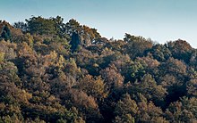
Druid Stone


The Druidenstein is a cone-shaped basalt rocks in Northern Heller mountains above the town of churches on the victory in the local district Herkersdorf , district Altenkirchen . The basalt cone rises to 431 m above sea level. NN at a height of about 20 meters.
Emergence
The Druid Stone is around 25 million years old (Young- Tertiary ) and covers an area of around 100 m². It got its unusual shape when lava forced its way through the Devonian greywacke of the basement and then solidified. In this way, prismatic pillars formed perpendicular to the cooling surface .
Due to erosion , only the hard basalt core remained, but this crest continues to “shrink”. Other events have also reduced the size of the basalt cone.
history
The druid stone was probably already used by the Celts as a religious site and as a meeting place. The topmost point was probably broken off for tactical reasons during the Thirty Years' War so that enemy troops could not orientate themselves. At that time the top was still visible from afar and there was hardly any forest. In 1869 the druid stone was placed under nature protection. Today it is one of around 3,000 natural monuments in the state of Rhineland-Palatinate. In 1979 the Druid Stone was struck by lightning. The impact was so huge that the basalt cone then had to be supported with six reinforced concrete beams.
In addition, the druid stone was used, among other things, as a quarry for road construction .
Say
What exactly happened on the Druid Stone is not exactly proven. However, many legends and myths entwine around it. There are legends of Gallic druids , "wild people" and others who are said to have performed rituals and other things on the druid stone . It is also likely that the Druid Stone was a religious site of the Chatti , who built a thing site here and worshiped the sun.
Tourism and culture
In the 1950s, the festival took place on the "Druidenstein open-air stage". Pieces like Let there be light (1952), Wandulf der Waldschmied (1954) or Schulze Henrich (1955) were performed here. The actors came from the local room . In the early 1960s, however, the festival was discontinued.
Now and then there are open-air concerts on the basalt cone. Every year on Ascension Day , processions lead from Herkersdorf over the Stations of the Cross to "Köppel", where a holy mass is celebrated.
There are some hiking trails that lead from churches (Sieg) or other localities to the Druidenstein.
Web links
- The Druid Stone . Website of the Verbandsgemeinde Kirchen (Sieg)
- OutcropWizard: Druid Stone 3D Model. Retrieved June 26, 2020 .
Individual evidence
- ↑ a b The rock of the sun worshipers . In: The Rheinpfalz / Südwestdeutsche Zeitung . January 8, 2010.
Coordinates: 50 ° 47 ′ 41.6 " N , 7 ° 54 ′ 36.8" E


