
Blausteinsee
| Blausteinsee | ||
|---|---|---|

|
||
| Blausteinsee, west bank | ||
| Geographical location | North Rhine-Westphalia , Germany | |
| Data | ||
| Coordinates | 50 ° 51 '18 " N , 6 ° 16' 27" E | |
|
||
| surface | 1 km² | |


The Blausteinsee - officially the leisure and recreation focus Blausteinsee - is an approximately 100 hectare large and up to 46 meters deep artificial lake north of Eschweiler in the urban region of Aachen in western North Rhine-Westphalia . It was created as part of the recultivation of the former lignite opencast mine Zukunft in the Rhenish lignite mining area by filling the remaining open pit with surface water and today serves as a recreational area for the surrounding cities. Its water level is 129 m above sea level. NN . The total filling volume is around 25 million cubic meters . The filling started in 1994. Every year, 3.8 million m³ of water are pumped from the swamp wells of the Inden opencast mine into the lake so that it maintains its current level. According to the city region of Aachen, this feeding with swamp water will be necessary until the year 2061.
The Blausteinsee is operated by the Freizeitzentrum Blaustein-See GmbH, which was founded in 1982 as the municipal supporting company for the municipalities of Aldenhoven , Alsdorf , Eschweiler, Stolberg and Würselen . The aim of this company is to create and maintain an attractive leisure and recreational focus for the population of the Aachen city region and neighboring districts and to coordinate all activities in the area of the lake.
Location and description
.jpg)
The Blausteinsee lies entirely in the urban area of Eschweiler; only half of the serpentine ditch adjacent to the north lies within the territory of the municipality of Aldenhoven . The Dürwiß district with its wooded local recreation area with open-air swimming pool and youth traffic garden joins seamlessly on the southern shore of the lake, and the twin district of Fronhoven / Neu-Lohn on the eastern shore of the lake . The lake is surrounded by an 80 to 130 meter wide green belt in which there are hiking trails and separate bridle paths as well as a 10.3 km long skater track . Overall, the focus of leisure and recreation in the so-called Seemulde is around 180 hectares.
The diving zone with boarding aid and filling station is on the north-west bank, the bathing area with bathing beach and catering area on the west bank, while the north, north-east and east bank zone is a nature reserve .
fauna and Flora
The Blausteinsee is still young biologically. Cnidarians , crabs , water snails , amphibians and schools of small to medium-sized fish such as the carp-like rudd and roach ( whitefish ) as well as perch and eels can be observed in the lake, and the first aquatic plants are beginning to spread in the bank area. The immediate vicinity of the lake is characterized by wide fields, rows of trees, bushes and hedges. The 80 to 130 meter wide green belt consists of deciduous trees , shrubs, meadows and areas left to their own devices.
In 2008 the nature reserve Northeast Blausteinsee was designated with an area of 86.9 hectares . Of the approx. 100 hectares of the Blausteinsee, approx. 33 hectares of water area belong to the nature reserve. The lake is an oligotrophic (nutrient poor) lake. Various candelabrum algae occur at greater depths in the lake . The lake is a particularly important resting and feeding habitat for water birds, especially in the winter months when the surrounding stagnant waters freeze over. Regular winter guests are z. B. Goosander , pygmy hawk , pochard , pochard and little grebe . Due to the fluctuating water level of the lake, new habitats with pioneer species , some of which are poor in vegetation, are constantly forming along the shoreline , which are ideal living conditions for amphibians like the natterjack toad .


Serpentine Valley
The Schlangengrabental around the Schlangengraben is a hollow about 3.5 kilometers long and between 150 and 400 meters wide north of the lake in the direction of Aldenhoven. A forest grows on their embankments . In this elongated hollow, which is designated as a nature reserve in the southern part close to the lake, humid and alternately humid biotopes have been created. The snake ditch absorbs rainwater from the surrounding fields as well as the overflowing water from the lake and directs it north into a natural rain overflow .
geology
The loess soils found in the Börden landscape can store a great deal of moisture. This means that the Schlangengrabental only carries water after heavy rainfall. When the upper layers were tilted, the spreader swiveled its boom to the side in such a way that the forest gravel fell loosely on top of each other, resulting in a rib-shaped soil structure that is still preserved today. Subsequently, the surfaces were not leveled and the soil was not compacted so that it can better absorb water. Forest gravel is a substrate made from gravel and loess loam.
water sports

The Blausteinsee quickly developed into a magnet for recreational athletes. A diving area has been set up on the western shore of the lake . Due to the sandy subsoil, the visibility is one to seven meters, depending on the number of divers, the visibility is particularly good below 25 meters diving depth. Various attractions such as a Unimog , a dinghy wreck , an angel figure and trees were sunk in the lake , for which the Eschweiler diving club has made an underwater map. Even canoeists , rowers , swimmers , sailors and windsurfers use the Blausteinsee. However, kite surfing and model boats are prohibited on the lake.
The Erich Berschkeit Cup is held annually in the form of a regatta . It is named after the former mayor of Eschweiler (1984–1986) Erich Berschkeit , who made a decisive contribution to the lake.
Memory of the past landscape
Around the Blausteinsee several memorial stones and crosses remind of the villages excavated here. There is an overview board with numerous aerial photographs at the memorial chapel parish of Lohn . A 15 km long, designated historical path leads to Aldenhovener and Eschweiler municipal areas as a tour around the lake. His stops are the new hamlets Weiler Hausen and Weiler Langweiler as well as the Erbericher Kreuz, the Neulandkreuz and the memorial stones equipped with information boards for Langendorf , Langweiler , Laurenzberg , Lürken , Obermerz and the manor Hausen.
history
In 1981 the city of Eschweiler worked out concepts for an Eschweiler lake; previously the sailing club Eschweiler See was founded in 1979 . 1982 began the resettlement of the population from Erberich, Langendorf, Laurenzberg, Lürken, Langweiler and Obermerz mainly to Neu-Lohn and Fronhoven. The Blausteinsee GmbH was as a municipal Trägergesellschaft municipalities Aldenhoven , Alsdorf , Eschweiler Würselen founded and renamed the planned Eschweiler lake in Blaustein. The Blausteinsee was thus the first intercommunal project in the Aachen region .
It was named after the old district Am Blaue Stein north of Dürwiss. Even in old cadastral maps and Germans basic maps this name but not a place Blaustein break back, but on the standing formerly on the provincial road between Dürwiß and Fronhoven 3.50 meters high Fronhovener cross, a wayside cross from the 17th or 18th century .
After the last of 530 million tons of brown coal had been mined in the Zukunft-West open-cast lignite mine in 1987 , recultivation began. In the spring of 1994, the last spreader left the mine. The former mining field of the Zukunft and Zukunft-West opencast mines is almost 23 square kilometers. At the same time the access road to the Blausteinsee was named.
On October 5, 1994 the water filling of the Blausteinsee began. The water fountain was located about 500 m from the shore in the middle of the lake and sprayed 40 m high at about 210 liters of water per second. Up to 6.7 million cubic meters of water flowed into the lake every year, and at least 75 million cubic meters were required for the first filling, as up to 50 million cubic meters of water seeped away or evaporated.
In August 1997 the association of water sports clubs Blausteinsee 1997 e. V. , which emerged from the Blausteinsee interest group, which has existed since 1982 . On August 12, 2000, the Blausteinsee was officially opened and a temporary container village was built. In 2002, the Eschweiler See sailing club and the Alsdorf sailing club built their own jetty . Since August 2003, employees of a private security service have been patrolling the Blausteinsee in order to prevent wild barbecues, baths and nature protection zones from being entered. In August 2004, part of the lake was opened for swimming, and in 2005 it reached its final size of approximately 100 hectares with a maximum depth of 46 m. A large boulder on the west bank reminds of the first filling and opening.
EuRegionale 2008: Anchor point Blausteinsee
As part of a long-term project, the Blausteinsee will be integrated into the newly emerging Eschweiler / Inden landscape park named Indeland as a project of the EuRegionale 2008 . This landscape park is intended to combine the entire recultivated area of the Inden opencast mine under the theme of water . A similar project was implemented decades ago with the recultivation in the southern district of the Rhenish lignite mining district in what is now the Rhineland Nature Park west of Cologne .
On October 26, 2007, the North Rhine-Westphalian building minister Oliver Wittke symbolically threw an anchor into the lake to mark the opening of the construction phase . By August 2008, a floating stage with a grandstand for 950 spectators was built at the “anchor point Blausteinsee” . Since then, the lake center with a viewing platform, club accommodation, restaurants and a so-called water school have also been built. The state of North Rhine-Westphalia contributed 1.3 million euros to the total costs of 4.2 million euros.
In the sealing of the surface of the lake Blaustein a new method has been applied. Thus, it is considered a prototype for the lake planned between 2035 and 2050 in the neighboring Inden opencast mine .

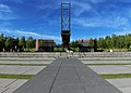
Floating stage

Seebühne taken from the viewing platform
Viewing platform from below
.jpg)
.jpg)
.jpg)
Transport links

The Blausteinsee is in the immediate vicinity of the country road 238 between Eschweiler, Dürwiß, Neu-Lohn / Fronhoven, Aldenhoven and Jülich. The next junctions are Aldenhoven on the A 44 and Eschweiler-West and Eschweiler-Ost on the A 4 . Bike paths are signposted.
.jpg)
The next two bus stops that are used all year round are on the south bank of the outdoor pool near Dürwiß and near the east bank of Wiesenstrasse near Fronhoven on line 6. During the summer holidays, the Blausteinsee has been served by the EW 5 (Blausteinsee shuttle) bus line since 2013.
| line | course |
|---|---|
| EW5 | Valley station / Raiffeisenplatz - Langwahn - indoor swimming pool - Eschweiler bus station - Dürwiss church - Dürwiss outdoor pool - Blausteinsee |
| 6th | ( Talbahnhof / Raiffeisenplatz - Hospital -) Eschweiler Bushof - Dürwiß - Neu-Lohn - ( Niedermerz -) Aldenhoven - Bourheim - Brückenkopfpark - Jülich Bf / ZOB |
The next train station is the Eschweiler valley station on the Mönchengladbach – Stolberg railway line , served by the Euregiobahn . The Blausteinsee shuttle starts there during the summer holidays.
See also
Literature and Sources
- Peter Bailly, Franz Josef Holzapfel: Discover Eschweiler. The hiking trails of the Eifelverein Eschweiler with descriptions of the local sights. Eifelverein Eschweiler, Düren 2002, ISBN 3-921805-24-4 .
- District government Münster as the upper land consolidation authority in cooperation with the Office for Agricultural Regulation Euskirchen: Historical path around the Blausteinsee (memories of the places Lürken, Laurenzberg, Langweiler, Obermerz and Langendorf). Brochure.
- Leo Braun: The Blausteinsee. Where does the name Blausteinsee come from? In: Series of publications by the Eschweiler history association. Volume 21, 2001, ISSN 0724-7745 , pp. 8-14.
- Adam Elsen: History of the city of Eschweiler in data (1800 to 1993), (= series of publications of the Eschweiler history association. Volume 14). Eschweiler History Association, Eschweiler 1993, DNB 94246642X .
- Christiane Krahn: The ribbon ceramic settlements in the upper Schlangengrabental. Studies on the ceramic settlement of the Aldenhovener Platte (= Rhenish excavations , Volume 57). von Zabern, Mainz 2006, ISBN 3-8053-3658-6 .
- Table template for the 23rd meeting of the Regional Council of the Regional Council of Kölnam on December 13, 2019, request from the DIE LINKE parliamentary group and the representative of the PIRATES Introduction of swamp water, future feeding of water into the Blausteinsee and its water quality
Web links
- Official homepage about the Blausteinsee
- Nature reserve “Nordostlicher Blausteinsee” in the specialist information system of the State Office for Nature, Environment and Consumer Protection in North Rhine-Westphalia
credentials
- ↑ Aseag: Blausteinsee-Shuttle special timetable ( Memento of July 3, 2014 in the Internet Archive ) (PDF). Retrieved July 3, 2014. (Memento)