
Low pain
|
Low pain
Aldenhoven municipality
|
|
|---|---|
 |
|
| Height : | approx. 120 m above sea level NHN |
| Area : | 3 km² |
| Residents : | 992 (Dec. 31, 2019) |
| Population density : | 331 inhabitants / km² |
| Incorporation : | January 1, 1972 |
| Postal code : | 52457 |
| Area code : | 02464 |

Niedermerz is a western part of Aldenhoven in the Düren district . It is located on the western side of Landstrasse 228 between Aldenhoven and Neu-Lohn . Neighboring towns are Schleiden , Aldenhoven-West , the hamlet of Hausen and the hamlet of Langweiler . The Merzbach flows through the village . Niedermerz formed with the stream lying above the curve top Merz a Doppelort until upper Merz in the course of lignite mine future demolished 1972nd
history
The nearby Merzbachtal is the site of numerous archaeological finds: ceramic settlement sites (see also Langweiler 8 ), remains of Roman walls and 60 Franconian graves including two princess graves with amber chains and other jewelry. The Roman road probably ran from Aachen to Jülich via Niedermerz.
The Catholic parish church is dedicated to St. John the Baptist . Its church tower from the 12th century is the oldest building in Niedermerz. A special feature of the church is the fact that the main altar is in the tower. It is also noticeable that the tower faces east, which only applies to a few churches. The current nave was rebuilt in the 18th century. The new cemetery and morgue are from 1966.
In 1902 there were still four water pumps in Niedermerz, and in 1908 the place was connected to the electricity grid and in 1911 to the central water supply in Aldenhoven. The school was built in 1829 and has been a restaurant since 1978. In 2009 the school was completely converted into rental apartments.
On July 1, 1969, Langweiler was incorporated into Niedermerz. Since June 1, 2014, the hamlet of Langweiler has belonged to Schleiden and no longer to Niedermerz. On January 1, 1972 Niedermerz was incorporated into Aldenhoven. Since 1999 the hamlet of Hausen has been assigned to the Niedermerz district.
On May 16, 1971, the foundation stone for the "House of the Village" was laid, and the building was inaugurated on September 4, 1972. It is primarily used for afternoons for the elderly, handicraft groups, fire brigade exercises, carnival events and dance group rehearsals.
politics
coat of arms
The Niedermerzer coat of arms shows in a red and gold halved shield above in silver the lamb of God with a cross banner and below three black crossbars.
The lamb points to the parish priest Johannes the Baptist, the crossbars to the gentlemen von Palant from Laurenzberg , who from the Laurenzberger Burg helped to determine the development of Niedermerz.
Architectural monuments

Niedermerz rectory
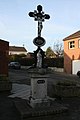
Crossroads in the canal
Crossroads Von-Paland-Straße / Dürboslarer Straße
.jpg)
.jpg)
.jpg)
traffic
The next junction to the motorway network is "Aldenhoven" on the A 44 . The nearest train stations are "Alsdorf-Anna Park" at the Euregiobahn , "Julich Station" at the Rurtalbahn and " Eschweiler Central Station " on the route Cologne - Düren - Aachen . The place is served by the AVV bus line 6 (Jülich - Bourheim - Aldenhoven [- Niedermerz] - Neu-Lohn - Dürwiß - Eschweiler bus station )
Individual evidence
- ↑ https://www.aldenhoven.de/rathaus/online-dienste/dienstleistungen/buergerbuero/einwohnerzahlen.php#c1
- ↑ Martin Bünermann: The communities of the first reorganization program in North Rhine-Westphalia . Deutscher Gemeindeverlag, Cologne 1970, p. 99 .
- ↑ Population figures on the municipality's website, Notes section ( Memento of the original dated January 6, 2014 in the Internet Archive ) Info: The archive link was inserted automatically and has not yet been checked. Please check the original and archive link according to the instructions and then remove this notice.
- ^ Federal Statistical Office (ed.): Historical municipality directory for the Federal Republic of Germany. Name, border and key number changes in municipalities, counties and administrative districts from May 27, 1970 to December 31, 1982 . W. Kohlhammer, Stuttgart / Mainz 1983, ISBN 3-17-003263-1 , p. 308 .

Aldenhoven with Pützdorf | Dürboslar | Engelsdorf | Freialdenhoven | Boring (desert) | New pattern | Niedermerz with Weiler-Hausen | Obermerz (desert) | Schleiden with hamlet Langweiler | Siersdorf