Rožnovská Bečva
| Rožnovská Bečva | ||
|
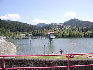
Horní Bečva dam |
||
| Data | ||
| location | Czech Republic | |
| River system | Danube | |
| Drain over | Bečva → March → Danube → Black Sea | |
| source | on the northern slope of Vysoká 49 ° 24 ′ 21 ″ N , 18 ° 21 ′ 48 ″ E |
|
| Source height | 950 m nm | |
| confluence | at Valašské Meziříčí with the Vsetínská Bečva to the Bečva coordinates: 49 ° 28 ′ 12 ″ N , 17 ° 57 ′ 16 ″ E 49 ° 28 ′ 12 ″ N , 17 ° 57 ′ 16 ″ E |
|
| Mouth height | 288 m nm | |
| Height difference | 662 m | |
| Bottom slope | 18 ‰ | |
| length | 37.6 km | |
| Catchment area | 254.4 km² | |
| Drain |
MQ |
3.5 m³ / s |
| Reservoirs flowed through | Horní Bečva dam | |
The Rožnovská Bečva (German Lower Betschwa , formerly Czech Dolní Bečva ) is the right source river of the Bečva in the Czech Republic . It drains over the Bečva, March and Danube into the Black Sea .
It rises at 950 m on the northern slope of the Vysoká ( 1024 m ) not far from the border with Slovakia between the Vsetínské vrchy and the Moravian-Silesian Beskids , where the White Ostrawitza , which drains over the Oder into the Baltic Sea, originates one kilometer to the east takes.
Horní Bečva , Prostřední Bečva , Dolní Bečva and Rožnov pod Radhoštěm , where their direction changes to the west, lie on their north-west course . The valley of the Rožnovská Bečva in its upper reaches forms the natural boundary between the Moravian-Silesian Beskids in the north and the Vsetínské vrchy in the south.
Other places on the river are Zubří , Střítež nad Bečvou , Zašová and Valašské Meziříčí .
After 37.6 km it joins the Vsetínská Bečva at Valašské Meziříčí .
