
Bečva
| Bečva | ||
_-_location_and_watershed.svg) Course and catchment area of the Bečva |
||
| Data | ||
| location | Czech Republic | |
| River system | Danube | |
| Drain over | March → Danube → Black Sea | |
| source | At Valašské Meziříčí from Vsetínská Bečva and Rožnovská Bečva 49 ° 28 ′ 12 ″ N , 17 ° 57 ′ 16 ″ E |
|
| Source height | 288 m nm | |
| muzzle | At Troubky in the March coordinates: 49 ° 25 ′ 7 ″ N , 17 ° 19 ′ 17 ″ E 49 ° 25 ′ 7 ″ N , 17 ° 19 ′ 17 ″ E |
|
| Mouth height | 195 m nm | |
| Height difference | 93 m | |
| Bottom slope | 1.5 ‰ | |
| length | 61.5 km | |
| Catchment area | 1,625.7 km² | |
| Drain |
MQ |
17.5 m³ / s |
| Left tributaries | Juhyně | |
| Right tributaries | Jezernice , Ludina , Velička | |
| Medium-sized cities | Přerov , Valašské Meziříčí | |
| Small towns | Hranice , Lipník nad Bečvou | |
 The Bečva in Přerov |
||
The Bečva (German Betschwa , also Betsch , Beczwa ) is a left tributary of the March in the Czech Republic . It arises in Valašské Meziříčí through the confluence of the Vsetínská Bečva ( Upper Betschwa ) and Rožnovská Bečva ( Lower Betschwa ).
Run
Be on its course to the northwest the places Lhotka nad Bečvou , Choryně , Hustopeče nad Bečvou , Milotice nad Bečvou , Černotín , Teplice nad Bečvou , hranice , Zadní family Přední family, Týn nad Bečvou , Lipník , Osek nad Bečvou , Oldřichov na Moravě , Prosenice , Radslavice u Přerova and Přerov . After 61.5 km the Bečva flows into the March at Troubky .
The Bečva flows through the Weißkirchen Karst near Hranice. On the right bank of the river is the Hůrka u Hranic nature reserve with the 289.5 m deep Weißkirchen Abyss .
The Malá Bečva has its origin at the Bečva weir in Troubky . This arm of the river follows the March on the left and flows into the Moštěnka .
history
The first written mention of the river and its two source rivers took place during the great colonization in 1215 under the name Betsch and Beyx .
Tributaries
- Juhyně (l) near Choryně
- Ludina and Velička (r) in Hranice
- Splavná (r), below Hranice
- Drahotušský potok (r) near Rýbaře
- Zabník (r), above the Zadní family
- Jezernice (r), with the Přední family
gallery

Bečva Bridge at Rybáře

Confluence with the March

Hůrka u Hranic

At Grymov
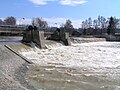
Dam in Osek nad Bečvou

.jpg)
.jpg)

