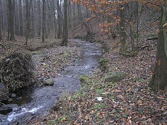
Jezernice (Bečva)
| Jezernice | ||
|
The Jezernice in the Oder Mountains |
||
| Data | ||
| location | Olomoucký kraj ( Czech Republic ) | |
| River system | Danube | |
| Drain over | Bečva → March → Danube → Black Sea | |
| source | northeast of Kozlov in the Oder Mountains 49 ° 36 ′ 42 ″ N , 17 ° 33 ′ 51 ″ E |
|
| Source height | 646 m nm | |
| muzzle | at the Přední family across from the Helfštýn Castle in Bečva coordinates: 49 ° 31 '43 " N , 17 ° 37' 44" E 49 ° 31 '43 " N , 17 ° 37' 44" E |
|
| Mouth height | 232 m nm | |
| Height difference | 414 m | |
| Bottom slope | 32 ‰ | |
| length | 13.1 km | |
| Catchment area | 21.3 km² | |
| Drain |
MQ |
160 l / s |
The Jezernice ( German Jeserskybach ) is a right tributary of the Bečva in the Czech Republic.
geography
The Jezernice rises two kilometers northeast of Kozlov on the eastern slope of the Křížový Kopec ( Cross Hill , 661 m ) in the Oberhuben Mountains , part of the Oder Mountains on the Libavá military training area . Its source is on the Zelený kříž ( Green Cross ) on the road from Potštát to Velký Újezd . For the first one and a half kilometers it runs south along the road to the northeast and then forms a deeply cut valley that leads past the Čertovy kazatelny ( Devil's Pulpit ) via Peklo and the Drahotuš castle ruins to the southeast. The upper reaches of the Jezernice belong to Zone C of the restricted area up to Peklo, which is accessible on weekends and public holidays.
In Podhoří the Jezernice enters the Moravian plain and is bridged by the D1 / E 462 motorway below the village . Its lower course leads through Jezernice to the south. South of the village, the Přerov – Bohumín railway on the Jezernice viaduct and the state road I / 47 / E 442 lead to another bridge at Přední family across the river. Southwest of the Přední family, the Jezernice flows into the Bečva after 13.1 km opposite the Helfštýn castle . Its catchment area is 21.3 km².
Tributaries
- Černý potok (r), Peklo
