Dürboslar
|
Dürboslar
Aldenhoven municipality
Coordinates: 50 ° 54 ′ 18 ″ N , 6 ° 15 ′ 14 ″ E
|
|
|---|---|
| Height : | 109 m above sea level NHN |
| Residents : | 639 (Dec. 31, 2019) |
| Incorporation : | January 1, 1972 |
| Postal code : | 52457 |
| Area code : | 02464 |
|
Dürboslar
|
|
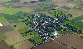
Dürboslar is a district and a district of the municipality of Aldenhoven in the district of Düren , North Rhine-Westphalia .
location
Dürboslar is located north of Aldenhoven, east of Siersdorf , west of Engelsdorf and south of Freialdenhoven .
history
Dürboslar was first mentioned in 898. The Dürboslar moated castle was mentioned in a document in 1478. Until the end of the 18th century, the place belonged to the Oberamt Jülich in the Duchy of Jülich . In 1787 Dürboslar had 366 inhabitants.
After the Left Bank of the Rhine was taken by French revolutionary troops (1794), Dürboslar belonged to the canton of Linnich in the Département de la Roer from 1798 to 1814 . As a result of the agreements made at the Congress of Vienna (1815), the region and with it Dürboslar became part of the Kingdom of Prussia . The municipality of Dürboslar was assigned to the mayor's office of Freialdenhoven in the Jülich district and from 1822 was part of the Rhine province . In 1830 Dürboslar had 524 inhabitants.
After a few previous churches , the current hall church was built from 1904 to 1906. It was not destroyed in World War II and is St. Ursula consecrated.
On January 1, 1972 Dürboslar was incorporated into Aldenhoven.
Architectural monuments
traffic
The federal highway 56 runs directly on the eastern edge of the village and the federal highway 44 to the south of the village . The ASEAG bus line 90 runs through Dürboslar .
literature
- Ulrich Coenen: Architectural treasures in the Düren district. 2nd edition, Verlag Mainz, Aachen 1989.
Web links
Individual evidence
- ↑ https://www.aldenhoven.de/rathaus/online-dienste/dienstleistungen/buergerbuero/einwohnerzahlen.php#c1
- ^ Wilhelm Fabricius : Explanations of the historical atlas of the Rhine province, 2nd volume: The map of 1789. Bonn, Hermann Behrend, 1898, p. 269
- ↑ August Christian Borbeck: Archive for the history, description of the earth, statistics and antiquities of the German Lower Rhineland , Volume 1, Part 1, Comptoir für Litteratur, 1800, p. 130 ( Google Books )
- ↑ Friedrich von Restorff : Topographical-Statistical Description of the Royal Prussian Rhine Province , Nicolai, Berlin and Stettin 1830, p. 791 ( Google Books )
- ^ Federal Statistical Office (ed.): Historical municipality directory for the Federal Republic of Germany. Name, border and key number changes in municipalities, counties and administrative districts from May 27, 1970 to December 31, 1982 . W. Kohlhammer, Stuttgart / Mainz 1983, ISBN 3-17-003263-1 , p. 308 .


