Gable forest
| Gable forest | ||
|---|---|---|
|
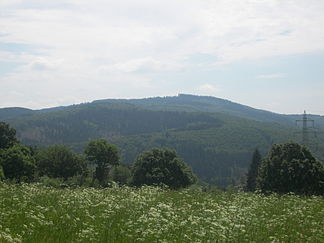
The Giebelberg in the Giebelwald |
||
| Highest peak | Giebelberg ( 527.8 m above sea level ) | |
| location | Altenkirchen district and Siegen-Wittgenstein district ; Rhineland-Palatinate and North Rhine-Westphalia ( Germany ) | |
| part of | Siegerlandes | |
| Classification according to | Emil Meynen and the Federal Agency for Nature Conservation | |
|
|
||
| Coordinates | 50 ° 50 '37 " N , 7 ° 54' 37" E | |
| surface | 20 km² | |
The Giebelwald is a right of the victory at Mudersbach situated mountain range in the winner country . It is located in the district of Altenkirchen and the district of Siegen-Wittgenstein in Rhineland-Palatinate and North Rhine-Westphalia . The densely wooded ridge is 527.8 m above sea level on the Giebelberg . NHN high.
geography
location
The gable forest spreads between Oberschelden in the northeast, Mudersbach in the southeast, Kirchen in the southwest and Niederfischbach in the northwest; the city center of Siegen is about 8.5 km northeast of the forest area. It is about 6 km long in the southeast-northwest direction and about 4 km wide in the northeast-southwest direction.
Natural allocation
The Giebelwald (331.5), part of the natural Siegerland (main unit 331), together with the Hellerbergland (331.3) adjoining it to the south, forms a bar that separates the core Siegerland with the Siegener Kessel in the east from the central Sieg-Bergland (main unit 330 ) belonging to Morsbacher Bergland (330.21). In the Niederschelden-Betzdorfer Siegtal (331.4), the victory breaks this bolt.
In addition to the actual ridge, the Giebelwald natural area also includes the densely wooded valley of the Untere Asdorf that adjoins it to the west from near its mouth upstream to just above the mouth of the Löcherbach .
Flowing waters
Due to the small extent and at the same time being closed off as a mountain range, there are only smaller flowing waters in the interior of the gable forest. The following streams, arranged clockwise (starting in the east), originate in the gable forest (target waters in brackets and length and - if known - size of the catchment area ):
- Schinderbach (to Gosenbach ; 3.7 km, 3.945 km²)
- Ölsbach (to Sieg ; 1.4 km, 1.345 km²)
- Vollmersbach (to Sieg; 3.8 km, 4.969 km²)
- Wehbach (to Asdorf ; 1.7 km)
- Käsbach (to the Uebach, 2.0 km)
- Uebach with NSG Uebachtal (to Fischbach ; 3.4 km, 5.645 km²)
The valley of the Asdorf is accompanied by meadows Kerbsohlental , the valleys of the smaller streams are weakly pronounced V-shaped valleys .
Localities
The continuously wooded and practically unpopulated gable forest is clearly separated from its surroundings by heavily populated river and stream valleys. In a clockwise direction, these are (localities are indented opposite the flowing waters):
-
Schelderbach (downstream, northeast border)
- Oberschelden (northeast)
- Gosenbach (north east)
-
Gosenbach (downstream, southern eastern border)
- Niederschelderhütte (district of Mudersbach, but immediately west of Niederschelder ; south-east)
-
Victory with the Niederschelden-Betzdorfer Siegtal (downstream, southern border)
- Mudersbach (southeast)
- Brachbach (east south)
- Churches (west south)
-
Asdorf (upstream, west and north-west border )
- Niederfischbach (northwest)
-
Fischbach (upstream, middle northern border)
- Niederndorf (north)
- Oberfischbach (east north)
-
Heisberg (upstream, eastern northern border)
- Heisberg (extreme northeast)
nature
geology
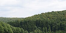
The gable forest is an almost completely wooded hardwood ridge made of resistant gray- wacky sandstone and clay slate , in which siderite tunnels are sometimes enclosed.
Flora and fauna
The gable forest is wooded with mixed forest and spruce forest at high altitudes , in lowlands primarily with deciduous forest, including in particular the coppice forest with Haubergen, which is typical for the Siegerland . The main plants are beech , birch , oak , maple and spruce, and there is also a lot of dead wood in the gable forest. Deadwood is an important part of forests as a habitat and source of food for many animals. The animals of the gable forest include red deer , fallow deer , roe deer , wild boar , foxes , martens , red kites , buzzards , jays , toads , salamanders , forest lizards , slow worms , Grass snakes and countless arthropods .
Protected areas
Parts of the landscape protection areas Freudenberg ( CDDA no. 390054; designated 2003; 42.3403 km² in size) and Siegen (CDDA no. 390075; 2008; 75.9459 km²), the fauna-flora-habitat area Giebelwald ( FFH no. 5113-302; 10.73 km²) and the Westerwald bird sanctuary (VSG no. 5312-401; 28.948 ha ). On the northern edge is the Uebachtal nature reserve ( CDDA no. 378305; 2003; 16.93 ha).
Traffic and walking
The federal motorway 45 runs north-east past the gable forest , from which the federal road 62, which runs through the valley of the Sieg, branches off at the Siegen junction, a little east-northeast of the forest area . State and district roads lead through other stream valleys . There are many hiking trails and paths in the forest, for example the European long-distance hiking trail E1 and the 6.8 km long Giebelwaldrundweg .
Individual evidence
- ↑ Map service of the landscape information system of the Rhineland-Palatinate nature conservation administration (LANIS map) ( notes )
- ↑ a b c Landscapes in Rhineland-Palatinate: Giebelwald , on naturschutz.rlp.de
- ↑ a b Map services of the Federal Agency for Nature Conservation ( information )
- ↑ Map services of Rhineland-Palatinate with maps of natural and landscape areas (→ Landscape experience → Landscapes in Rhineland-Palatinate), on naturschutz.rlp.de
- ↑ Topographical Information Management, Cologne District Government, Department GEObasis NRW ( Notes )
literature
- Gerhard Skrobicki / West German Broadcasting: Here and Today - Strolls Schlütersche-Verlag


