
Auel (Hennef)
|
Owl
City of Hennef (Sieg)
Coordinates: 50 ° 46 ′ 11 ″ N , 7 ° 21 ′ 51 ″ E
|
||
|---|---|---|
| Height : | 80 m above sea level NN | |
| Residents : | 83 (Jan 2020) | |
| Postal code : | 53773 | |
| Area code : | 02242 | |
Location of Auel in North Rhine-Westphalia |
||
 Aerial view of Auel
|
||

Auel is a district of the city of Hennef (Sieg) in the Rhein-Sieg district in North Rhine-Westphalia .
location
The hamlet lies at a height of 80 meters above sea level on the north bank of the Sieg in the district of Blankenberg . Neighboring towns are Oberauel in the northwest and Berg in the north. On the other side of the Sieg, the town of Blankenberg rises above the steep cliffs of the Hardt .
history
In 1910 Auel had the households Ackerer Heinrich Becker, Ackerer Heinrich Beiert, Ackerin Katharina Broscheid, Ackerer and Ackerer Adolf Driesch, Day Laborer Franz Hänscheid, Farmer Widow Gottfried Honrath, the Rottenarbeiter Franz Heinrich and Paul Jaeschke, Farmer Widow Heinrich Leßenich, Agricultural Man Johann Mücher , day laborers Peter Josef Müller, composting worker Karl Paffrath, trader and field assistant Peter Schuster, foreman Peter Steinhauer, postman Wilhelm Steinhauer, a day laborer Johann Walterscheid, day laborers Wilhelm Wuddel, Ackerin Elisabeth Zimmermann and Ackerer Josef Zimmermann.
Until 1934 Auel belonged to the municipality of Blankenberg .
Architectural monuments
As a monument under monument protection in Auel are four half-timbered houses and barns and a water pump .
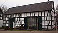
Former half-timbered barn, Im Auel 13 (2015)

Individual evidence
- ^ Hennef: Housing directory , residents ' registration office of the city of Hennef
- ^ Population register Siegkreis 1910
Web links
- Website of the Heimatverein Bödingen (also includes Auel)

Adscheid | Ahrenbach | Allner | Altenbödingen | Old luck | Auel | Beiert | Mountain | Blankenbach | Bödingen | Bröl | Bülgenauel | Büllesbach | Büllesfeld | Dahlhausen | Dambroich | Darscheid | Depensiefen | Derenbach | Dondorf | Dürresbach | Eichholz | Eulenberg | Fernegierscheid | Atrocities | Hahnenhardt | Halberg | Halmshanf | Hemp | Happerschoß | House Oelgarten | Heckelsberg | Womb | Hennef Center | Hermesmühle | Hofen | Hommerich | Hossenberg | Hove | Hüchel | Hülscheid | Issertshof | Käsberg | Kningelthal | Knippgierscheid | Köschbusch | Kraheck | Kümpel | Kurenbach | Kurscheid | Lanzenbach | Lauthausen | Lescheid | Lichtenberg | Liesberg | Löbach | Lückert | Meisenbach | Michelshohn | Mittelscheid | Niederhalberg | Oberauel | Oberhalberg | Petershohn | Raveneck | Ravenstein | Rott | Röttgen | Rütsch | Thief | Scheuren | Scheurenmühle | Söven | Sommershof | City of Blankenberg | Stone | Shock village | Striefen | Addiction divorce | Theishohn | Uckerath | Water heat | Weingartsgasse | Weldergoven | Wellesberg | Westerhausen | Reverberation | Wiersberg | Rock-nonsense | To the Farm