Berg (Hennef)
|
mountain
City of Hennef (Sieg)
Coordinates: 50 ° 46 ′ 34 " N , 7 ° 21 ′ 34" E
|
||
|---|---|---|
| Height : | 130 m above sea level NHN | |
| Residents : | 58 (Jan 2020) | |
| Postal code : | 53773 | |
| Area code : | 02242 | |
|
Location of Berg in North Rhine-Westphalia |
||
|
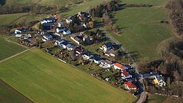
Hennef-Berg, aerial photo (2015)
|
||
Berg is a district of the city of Hennef (Sieg) in the Rhein-Sieg district in North Rhine-Westphalia .
location
The hamlet is at an altitude of 130 m above sea level. NHN on the slopes of Bergisches Land and the Nutscheid . Neighboring towns are Oberauel in the southwest and Niederhalberg in the north.
history
In 1910 there were the households Ackerer Wilhelm Löbach and Ackerer Heinrich Weber in Berg.
Until August 1, 1969, the village of Berg belonged to the municipality of Lauthausen . As part of the municipal reorganization of the Bonn area , Lauthausen, and thus also the village of Berg, was assigned to the then new, unofficial municipality "Hennef (Sieg)".
Individual evidence
- ^ Hennef: Housing directory , residents ' registration office of the city of Hennef
- ^ Population register Siegkreis 1910
Web links
Commons : mountain collection of images
- Website of the Heimatverein Bödingen (also includes mountain)


