South Central Timor
| Kabupaten Timor Tengah Selatan South Central Timor Governorate
|
||
|---|---|---|
 |
||
| Symbols | ||
|
||
| Basic data | ||
| Country | Indonesia | |
| province | East Nusa Tenggara | |
| Seat | Soe | |
| surface | 3947 km² | |
| Residents | 440,470 (2010) | |
| density | 112 inhabitants per km² | |
| ISO 3166-2 | ID-NT | |
| Landscape near Ayotupas | ||
Coordinates: 9 ° 28 ′ S , 124 ° 48 ′ E
South Central Timor ( Timor Tengah Selatan ) is a government district ( Kabupaten ) in the Indonesian part of West Timor . It is part of the East Nusa Tenggara Province . In 1959 the administrative district was formed from the traditional empires Molo , Amanatun and Amanuban .
440,470 people live in South Central Timor (2010 census).
geography
South Central Timor has an area of 3,947 km². The capital is Soe .
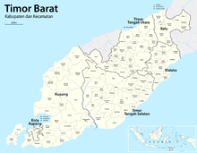
The Kabupaten is divided into the Kecamatans (districts) North Mollo (Mollo Utara), Fatumnasi , Tobu , Nunbena , South Mollo (Mollo Sealtan), Poland , West Molo (Mollo Barat), Central Molo (Molloh Tengah), Kota Soe (Soe City), West -Amanuban (Amanuban Barat), Batu Putih , Kuatnana , South Amanuban (Amanuban Selatan), Noebeba , Kuan Fatu , Kualin , Central Amanuban (Amanuban Tengah), Kolbano , Oenino , East Amanuban , Fatukopa Timur , Fautmolo , Kie , Kot'olin , South Amanatun (Amanatun Selatan), Boking , Nunkolo , Noebana , Santian , North Amanatun (Amanatun Utara), Toianas and Kokbaun .
In the northwest lies the highest mountain in West Timor at 2,427 m , the Mutis .
Web links
Individual evidence
- ↑ Jacob Wadu et al. (2003): Sejarah Pemerintahan Kabupaten Timor Tengah Selatan. Penfui: Lembaga Penelitian Universitas Nusa Cendan, pp. 103-106
- ↑ Penduduk Indonesia menurut desa 2010 ( Memento from March 27, 2014 in the Internet Archive ) (Indonesian; PDF; 6.0 MB), accessed on January 26, 2013


