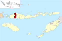
Manggarai
| Kabupaten Manggarai Manggarai
|
|
|---|---|
 |
|
| Basic data | |
| Country | Indonesia |
| province | East Nusa Tenggara |
| Seat | Downdraft |
| surface | 4,188.9 km² |
| Residents | 484,015 (2004) |
| density | 116 inhabitants per km² |
| ISO 3166-2 | ID-NT |
| Website | www.manggarai.go.id (Indonesian) |
Coordinates: 8 ° 37 ′ S , 120 ° 28 ′ E
Manggarai is a government district ( Kabupaten ) in the west of the island of Flores in the Indonesian province of East Nusa Tenggara . The capital of the administrative district is Ruteng .
The administrative district is the settlement area of the people of the same name. The Manggarai are best known for their ritual whip fight caci , which is now also a tourist attraction.
In 2004, 484,015 people lived in the 4188.9 square kilometers of the administrative district.
Individual evidence
- ↑ manggarai.go.id: Lektak geografis Kabupaten Manggarai (accessed March 9, 2013).
Web links
Commons : Manggarai - collection of images, videos and audio files
- Catherine Allerton: The Path of Marriage. Journeys and transformation in Manggarai, eastern Indonesia. In: Bijdragen tot de Taal-, Land- and Folklore. 160, No. 2-3, Leiden 2004, pp. 339-362.
