Belu (administrative district)
| Kabupaten Belu Belu Governorate
|
||
|---|---|---|
 |
||
| Symbols | ||
|
||
| Basic data | ||
| Country | Indonesia | |
| province | East Nusa Tenggara | |
| Seat | Atambua | |
| surface | 1,284.9 km² | |
| Residents | 420,000 (2010) | |
| density | 327 inhabitants per km² | |
| ISO 3166-2 | ID-NT | |
| Border crossing to East Timor | ||
Coordinates: 9 ° 6 ′ S , 124 ° 54 ′ E
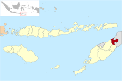
Belu is a government district ( Kabupaten ) in the Indonesian part of West Timor . It is part of East Nusa-Tenggara Province and was established in 1958.
geography
Belu consists of twelve districts ( Kecamatan ). There are 81 villages in them. Belu has an area of 1284.94 km².
| District | Administrative headquarters | location |
|---|---|---|
| Rai Manuk | Faturika | South of Belus |
| Western Tasifeto ( Tasifeto Barat ) | Kimbana | Center Belus in the west |
| Kakuluk Mesak | Umaresis | On the coast in the northwest of Belus |
| Nanaet Dubesi | Nanaet Dubesi | Southeast Belus |
| Atambua ( Kota Atambua ) | Atambua | North Belus |
| West Atambua ( Atambua Barat ) | Sesekoe | North Belus |
| South Atambua ( Atambua Selatan ) | Asuulun | North Belus |
| East Tasifeto ( Tasifeto Timur ) | Vedomu | North Belus with the eastern part of the coast |
| Raihat | Haekesak | Northeast Belus |
| Lasiolate | Lahurus | Northeast Belus |
| Llama cans | Weluli | Northeast Belus |
| South Lamaknen ( Lamaknen Selatan ) | Lutarato | Northeast Belus |
Belu borders the state of East Timor in the east . The affiliation of 37 hectares between Dilumi in Belu and the East Timorese memo has long been controversial. It was not until March 2013 that an agreement on the demarcation of the two countries was reached. The administrative districts of South Central Timor and North Central Timor are to the west and Malaka to the south . The capital of Belu is Atambua . Atapupu river port is of local importance.
Residents
420,000 people live in Belu (2010). In contrast to the rest of West Timor, languages are spoken here that are otherwise only used in East Timor. The most widespread mother tongue is Tetum, but Bekais , Bunak (in the districts of Lamaknen, South Lamaknen and Raihat) and Kemak are also traditionally spoken here. Almost all of the residents are Catholics.
history
1916 founded Dutch government districts Belu Tasi Feto and Malaka .
Belu Tasi Feto was named on the one hand after Belu , the old, colonial name for the eastern part of the island of Timor (the name "Belu" comes from the Tetum and means "friend" in German ), on the other hand after the local name of north of Timor located sea, Tasi Feto (Frauenmeer).
Belu was under the rule of the Raja of Jenilu , Malaka under the Liurai Tere Seran . The closest seat of the Dutch colonial administration was Atapupu, later Atambua. In 1924, both administrative districts were combined into one.
On December 14, 2012, Malaka was separated from Belu as a separate Indonesian administrative district.
Individual evidence
- ^ Government of Indonesia: Establishment of the Second-level Administrative Regions under the First-level Administrative Region of Bali, West Nusa Tenggara and East Nusa Tenggara, No. 69/1958 of August 9, 1958
- ↑ Penduduk Indonesia menurut desa 2010 ( Memento from March 27, 2014 in the Internet Archive ) (Indonesian; PDF; 6.0 MB), accessed on January 26, 2013
- ↑ Yustinus Nahak: Kecamatan di Kabupaten Belu . June 23, 2012, accessed July 28, 2014.
- ^ Map of Belu County , accessed July 28, 2014.
- ↑ Vivanews, November 7, 2009, Indonesia - E Timor under Borderline Dispute ( Memento of February 25, 2010 in the Internet Archive )
- ^ Suara Timor Lorosae: Batugade and Suai borders have had agreement , March 11, 2013
- ^ The Languages of East Timor: Some Basic Facts ( July 20, 2008 memento in the Internet Archive )
- ↑ a b c James J. Fox (Ed.): The Flow of Life: Essays on Eastern Indonesia , pp. 253/354.
- ↑ RUU Tentang Pembentukan Kabupaten Malaka di Provinsi Nusa Tenggara Timur ( Memento from January 31, 2013 in the Internet Archive ) (PDF; 274 kB)


