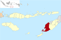
Kupang (administrative district)
| Kabupaten Kupang Kupang District
|
||
|---|---|---|
 |
||
| Symbols | ||
|
||
| Basic data | ||
| Country | Indonesia | |
| province | East Nusa Tenggara | |
| Seat | Oelamasi | |
| surface | 5,805.3 km² | |
| Residents | 373,663 (2008) | |
| density | 64 inhabitants per km² | |
| ISO 3166-2 | ID-NT | |
| Website | www.kab-kupang.go.id (Indonesian) | |
Coordinates: 10 ° 18 ′ S , 123 ° 43 ′ E
Kupang is a government district ( Kabupaten ) in the Indonesian part of West Timor . It is part of the East Nusa Tenggara Province . 373,663 people live in the administrative district (2008).
geography
Kupang has an area of 5,895.30 km². It consists of the western tip of Timor and the island of Semau . In 2002 Rote Ndao and in October 2008 Sabu Raijua were separated from Kupang to form their own administrative districts. The border to the East Timorese exclave Oe-Cusse Ambeno has not been fully clarified in the village of Naktuka . The main town of the administrative district has been Oelamasi since October 22, 2010 . The city of Kupang (Kota Kupang) is directly subordinate to the province.
Districts
Kupang is divided into 24 districts ( Kecamatan ):
- Amabi Oefeto
- Amarasi
- Fatuleu
- Nekameses
- North Amfoang ( Amfoang Utara )
- East Amabi Oefeto ( Amabi Oefeto Timur )
- Ostamarasi ( Amarasi Timur )
- Ostamfoang ( Amfoang Timur )
- East Kupang ( Kupang Timur )
- Semau
- South Amarasi ( Amarasi Selatan )
- South Amfoang ( Amfoang Selatan )
- South Semau ( Semau Selatan )
- Sulamu
- Taebenu
- Takari
- Westamarasi ( Amarasi Barat )
- Westamfoang Daya ( Amfoang Barat Daya )
- Westamfoang Laut ( Amfoang Barat Laut )
- Westfatuleu ( Fatuleu Barat )
- West Kupang ( Kupang Barat )
- Central Amfoang ( Amfoang Tengah )
- Central Fatuleu ( Fatuleu Tengah )
- Central Cupang ( Kupang Tengah )
history
After the Dutch had established themselves in Kupang on Timor , their power on the island was initially limited to the region. By 1688 the Dutch East India Company (VOC) concluded treaties with the five small rulers in this area, the "five loyal allies" Sonbai Kecil , Amabi , Kupang- Helong , Amfo'an and Taebenu . In this year the Portuguese fortress in Kupang was finally captured. The fort was renamed Concordia . The alliance between the VOC and the Timorese allies was very stable. During this time there were only two rebellions, which were triggered by Timorese forces: In 1678, Raja Ama Besi of Kupang allied with the pro-Portuguese Amarasi to attack the successor to his throne. In 1744 a subordinate nobleman rebelled against the Raja of Kupang.
In 1917 the five loyal allies were united to form the new zelfbesturend landschap (self-governing area) Kupang. The new Raja of Kupang came from the Nisnoni family , a sideline of the Sonba'i . In February 1942, Kupang was one of the first targets of the Japanese invasion of Timor . In 1949 the Kupang area had 49,168 inhabitants. In 1955, the Indonesian central government ended the local monarchy in Kupang.
See also
Web links
Individual evidence
- ↑ www.nttprov.go.id ( Memento of the original from November 17, 2011 in the Internet Archive ) Info: The archive link was inserted automatically and has not yet been checked. Please check the original and archive link according to the instructions and then remove this notice.
- ↑ http://ntt.bps.go.id/ ( Memento from July 21, 2011 in the Internet Archive )
- ^ The Jakarta Globe, March 22, 2011, East Timor, Indonesia Agree to Solve Border Problems
- ↑ PERATURAN PEMERINTAH NOMOR 3 TAHUN 2006 TENTANG PEMINDAHAN IBUKOTA KABUPATEN KUPANG DARI WILAYAH KOTA KUPANG KE WILAYAH OELAMASI KABUPATEN KUPANG
- ↑ List of the administrative units of Indonesia down to the Desas 2010 ( Memento from April 6, 2013 in the Internet Archive ) (English; PDF; 5.9 MB)
- ↑ Hans Hägerdal: Rebellions or factionalism? Timorese forms of resistance in an early colonial context, 1650–1769 ( Memento of the original from December 8, 2015 in the Internet Archive ) Info: The archive link was inserted automatically and has not yet been checked. Please check the original and archive link according to the instructions and then remove this notice.
- ^ Royal Timor: Sonbai ( Memento from July 15, 2011 in the Internet Archive )
- ↑ a b H. G. Schulte Nordholt: The political system of the Atoni of Timor, Den Haag (1971) p. 155.


