Lembata
| Lembata | ||
|---|---|---|
| Aerial view of Teluk Waienga Bay on Lembata | ||
| Waters | Sawu Lake , Banda Lake | |
| Archipelago | Solor archipelago | |
| Geographical location | 8 ° 26 ′ S , 123 ° 28 ′ E | |
|
|
||
| length | 80 km | |
| width | 30 km | |
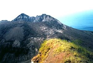
| The Iliwerung volcano | ||
Lembata ( Indonesian Pulau Lembata, Pulau Lomblen ) is the largest island in the Solor Archipelago , which in turn belongs to the Lesser Sunda Islands ( Indonesia ). The archipelago is part of East Nusa Tenggara Province .
geography
To the west of Lembata are the other islands in the archipelago, including Solor and Adonara , and further to the west, Flores . To the east of the island is the Strait of Alor , which separates the archipelago from the Alor archipelago . In the south, on the other side of the Sawu Sea, is the island of Timor and in the north is the western Banda Sea , which separates the island from Buton and the other islands from Southeast Sulawesi .
The northeast-southwest extension of the island of Lembata is about 80 kilometers and the east-west extension is about 30 kilometers. The shape of the island is reminiscent of a dolphin with a fountain from its breathing hole. The capital Lewoleba (also Labala ), which has the only larger port, is located in the west of the island on the bay of the same name . Further north is the Lewotolo volcano (also Gunung Ilê Ape ), which dominates the large peninsula at 1,450 m . Other volcanoes on the island are the Ililabalekan in the southwest and the Iliwerung in the south. They are considered active. The Batu Tara on the island of Komba , part of the Lembata administrative district, is the northernmost volcano.
Lembata forms an independent administrative district ( Kabupaten ), which is divided into nine districts ( Kecamatan ): In the west is Nubatukan with the island capital Lewoleba. To the north of it are on a peninsula (the fountain of the dolphin) Ile Ape with the main town Waupukang and Eastern Ile Ape ( Ile Ape Timur ) with Lemau . The Nagawutung district with the coastal town of Loang forms the extreme west and tip of the dolphin's nose . on the southwest coast is the district of Wulandoni with the port of the same name . The center of the dolphin head is the Atadei district with its main town Kalikasa in the mountains. The central part of the island consists of the Lebatukan district . Its main town, Hadakewa, is located on Waienga Bay on the north coast. Further to the east is the Omesuri district with the coastal town of Balauring and the tip of the tail in the far east is the Buyasari ( Buyasuri ) district with the main town of Wairiang .
On the coast of the Wulandoni district are the villages of Lamalera A and Lamalera B with around 1,800 inhabitants. Here, like in Lamakera on Solor, traditional whaling is still practiced with small boats. A few sperm whales, as well as sharks and dolphins, are shot each season with harpoons.
Ships commute regularly between Lewoleba and the neighboring islands, such as Larantuka , Flores and Waiwerang on the island of Adonara. From Belauring there is a ferry connection to Alor.
languages
Many rare languages still exist on Lembata. They belong to the central-eastern Malayo-Polynesian languages of the Malayo-Polynesian languages within the Austronesian languages .
| language | speaker | ISO 639-3 |
|---|---|---|
| Kedang | 30000 | ksx |
| Ile ape | 15000 | ila |
| Levuka | 4000 | lvu |
| Lewo Eleng | 4000 | lwe |
| Lamalera | 4000 | lmr |
| Lamatuka | 4000 | lmq |
history
The Portuguese were the first Europeans in the region in the 16th century. Lembata rarely visited them. With the exception of the inhabitants of a Muslim village, the population was followers of animism. At that time the island exported food, beeswax, turtle shells, products made from whales and slaves.
Web links
Individual evidence
- ↑ a b Map of Lembata ( Memento of the original from April 13, 2014 in the Internet Archive ) Info: The archive link was inserted automatically and has not yet been checked. Please check the original and archive link according to the instructions and then remove this notice.
- ↑ Merah Putih di Puncak Ile Ape ( Memento of the original from April 13, 2014 in the Internet Archive ) Info: The archive link was inserted automatically and has not yet been checked. Please check the original and archive link according to the instructions and then remove this notice.
- ↑ a b List of the administrative units of Indonesia down to the Desas 2010 ( Memento from April 6, 2013 in the Internet Archive ) (English; PDF; 5.9 MB)
- ^ In the village of the whalers: Lamalera.Retrieved August 15, 2014
- ↑ Fred Bruemmer: Sea Hunters of Lamalera. Bnet, Oct. 2001
- ↑ History of Timor ( Memento of the original from March 24, 2009 in the Internet Archive ) Info: The archive link was automatically inserted and not yet checked. Please check the original and archive link according to the instructions and then remove this notice. (PDF; 805 kB) - Technical University of Lisbon


